177.238.19.212 - IP Lookup: Free IP Address Lookup, Postal Code Lookup, IP Location Lookup, IP ASN, Public IP
Country:
 Mexico
Region:
City:
Location:
Time Zone:
Postal Code:
ISP:
ASN:
language:
User-Agent:
Proxy IP:
Blacklist:
IP information under different IP Channel
ip-api
Country
Region
City
ASN
Time Zone
ISP
Blacklist
Proxy
Latitude
Longitude
Postal
Route
db-ip
Country
Region
City
ASN
Time Zone
ISP
Blacklist
Proxy
Latitude
Longitude
Postal
Route
IPinfo
Country
Region
City
ASN
Time Zone
ISP
Blacklist
Proxy
Latitude
Longitude
Postal
Route
IP2Location
177.238.19.212Country
mxRegion
oaxaca
City
san lorenzo cacaotepec
Time Zone
America/Mexico_City
ISP
Language
User-Agent
Latitude
Longitude
Postal
ipdata
Country
Region
City
ASN
Time Zone
ISP
Blacklist
Proxy
Latitude
Longitude
Postal
Route
Popular places and events near this IP address
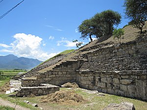
San José Mogote
Pre-Columbian archaeological site of the Zapotec
Distance: Approx. 3824 meters
Latitude and longitude: 17.1675,-96.80333333
San José Mogote is a pre-Columbian archaeological site of the Zapotec, a Mesoamerican culture that flourished in the region of what is now the Mexican state of Oaxaca. A forerunner to the better-known Zapotec site of Monte Albán, San José Mogote was the largest and most important settlement in the Valley of Oaxaca during the Early and Middle Formative periods (ca. 1500-500 BCE) of Mesoamerican cultural development.

Guadalupe Etla
Municipality and town in Oaxaca, Mexico
Distance: Approx. 4116 meters
Latitude and longitude: 17.16666667,-96.81666667
Guadalupe Etla is a village and municipality in the Mexican state of Oaxaca. The municipality has a total area of 17.86 km ². Guadalupe Etla is part of the region of the central valleys of Oaxaca.

Nazareno Etla
Municipality and town in Oaxaca, Mexico
Distance: Approx. 5845 meters
Latitude and longitude: 17.18333333,-96.81666667
Nazareno Etla is a town and municipality in Oaxaca in south-western Mexico. The municipality covers an area of 16.59 km². It is part of the Etla District in the Valles Centrales region.

San Agustín Etla
Municipality and town in Oaxaca, Mexico
Distance: Approx. 6602 meters
Latitude and longitude: 17.18333333,-96.76666667
San Agustín Etla is a town and municipality in Oaxaca in south-western Mexico. The municipality covers an area of 81.65 km2. It is part of the Etla District in the Valles Centrales region.
San Andrés Ixtlahuaca
Municipality and town in Oaxaca, Mexico
Distance: Approx. 7627 meters
Latitude and longitude: 17.06666667,-96.81666667
San Andrés Ixtlahuaca is a town and municipality in Oaxaca in south-western Mexico. The municipality covers an area of 33.17 km². It is part of the Centro District in the Valles Centrales region.

San Felipe Tejalapam
Municipality and town in Oaxaca, Mexico
Distance: Approx. 5632 meters
Latitude and longitude: 17.11666667,-96.85
San Felipe Tejalapam is a town and municipality in Oaxaca in south-western Mexico. The municipality covers an area of 76.55 km². It is part of the Etla District in the Valles Centrales region.
San Jacinto Amilpas
Municipality and town in Oaxaca, Mexico
Distance: Approx. 5130 meters
Latitude and longitude: 17.1,-96.76666667
San Jacinto Amilpas is a town and municipality in Oaxaca in southeastern Mexico and is the third most densely populated municipality in Oaxaca behind Santa Lucía del Camino and Santa Cruz Amilpas. The municipality covers an area of 12.76 km2. It is part of the Centro District in the Valles Centrales region.
San Lorenzo Cacaotepec
Municipality and town in Oaxaca, Mexico
Distance: Approx. 4 meters
Latitude and longitude: 17.13333333,-96.8
San Lorenzo Cacaotepec is a town and municipality in Oaxaca in south-western Mexico. The municipality covers an area of 12.76 km2. It is part of the Etla District in the Valles Centrales region.
San Pablo Etla
Municipality and town in Oaxaca, Mexico
Distance: Approx. 5634 meters
Latitude and longitude: 17.15,-96.75
San Pablo Etla is a town and municipality in Oaxaca in south-western Mexico. The municipality covers an area of 33.17 km². It is part of the Etla District in the Valles Centrales region.
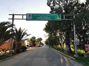
Soledad Etla
Municipality and town in Oaxaca, Mexico
Distance: Approx. 4116 meters
Latitude and longitude: 17.16666667,-96.81666667
Soledad Etla is a town and municipality in Oaxaca in south-western Mexico. The municipality covers an area of km². It is part of the Etla District in the Valles Centrales region.

Santa María Atzompa
Town & Municipality in Oaxaca, Mexico
Distance: Approx. 4267 meters
Latitude and longitude: 17.10138889,-96.77777778
Santa María Atzompa is a town and municipality located in the Mexican state of Oaxaca, about five km from the state capital of Oaxaca. It is part of the Centro District in the Valles Centrales region. The town was founded between the 7th and 9th centuries as a satellite of the ancient Zapotec city of Monte Albán.
Benito Juárez National Park
National park in Oaxaca, Mexico
Distance: Approx. 7565 meters
Latitude and longitude: 17.16805556,-96.73888889
The Benito Juárez National Park is in the Valles Centrales Region of Oaxaca, Mexico, and includes parts of the municipalities of San Felipe Tejalapam and San Andres Huayapan. The southern boundary of the park is about five kilometers north of the City of Oaxaca. The park was established in 1937 during the presidency of General Lazaro Cardenas del Rio, and is named after President Benito Juárez, who was a native of Oaxaca.
Weather in this IP's area
light rain
26 Celsius
25 Celsius
26 Celsius
26 Celsius
1013 hPa
36 %
1013 hPa
804 hPa
10000 meters
1.03 m/s
110 degree
75 %