Country:
 Mexico
Region:
City:
Latitude and Longitude:
Time Zone:
Postal Code:
IP information under different IP Channel
ip-api
Country
Region
City
ASN
Time Zone
ISP
Blacklist
Proxy
Latitude
Longitude
Postal
Route
IPinfo
Country
Region
City
ASN
Time Zone
ISP
Blacklist
Proxy
Latitude
Longitude
Postal
Route
MaxMind
Country
Region
City
ASN
Time Zone
ISP
Blacklist
Proxy
Latitude
Longitude
Postal
Route
Luminati
Country
MXRegion
mex
City
tlalnepantla
ASN
Time Zone
America/Mexico_City
ISP
Mega Cable, S.A. de C.V.
Latitude
Longitude
Postal
db-ip
Country
Region
City
ASN
Time Zone
ISP
Blacklist
Proxy
Latitude
Longitude
Postal
Route
ipdata
Country
Region
City
ASN
Time Zone
ISP
Blacklist
Proxy
Latitude
Longitude
Postal
Route
Popular places and events near this IP address

Tlalnepantla de Baz
Municipality in State of Mexico, Mexico
Distance: Approx. 2993 meters
Latitude and longitude: 19.53666667,-99.19472222
Tlalnepantla de Baz (Otomi: Ndemhāi) is one of 125 municipalities of the state of Mexico, north of Mexico City. The municipal seat and largest city in the municipality is the city of Tlalnepantla. Tlalnepantla comes from the Náhuatl words tlalli (land) and nepantla (middle) to mean the middle land.

Roman Catholic Archdiocese of Tlalnepantla
Roman Catholic archdiocese in Mexico
Distance: Approx. 2960 meters
Latitude and longitude: 19.5379,-99.1946
The Roman Catholic Archdiocese of Tlalnepantla (Latin: Archidioecesis Tlanepantlanus) is a Metropolitan Archdiocese in Mexico. Based in Tlalnepantla, México state, its suffragan dioceses include Cuautitlán, Ecatepec, Izcalli, Netzahualcóyotl, Teotihuacan, Texcoco, and Valle de Chalco.

Santa Cecilia Acatitlan
Distance: Approx. 1451 meters
Latitude and longitude: 19.55258333,-99.17333333
Acatitlan (Nahuatl: "place among the reeds"; Spanish "carrizal") is an archeological zone of the early Aztec (or early Toltec) culture located in the town of Santa Cecilia, in the municipality of Tlalnepantla de Baz in the State of Mexico, about 10 km northwest of Mexico City. In pre-Columbian times, it was located on the northwest shore of the great Lake Texcoco.
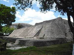
Tenayuca
Archaeological site in Mexico
Distance: Approx. 1025 meters
Latitude and longitude: 19.53216667,-99.16847222
Tenayuca (Nahuatl languages: Tenanyohcān pronounced [te.naˈyoʔ.kaːn]) is a pre-Columbian Mesoamerican archaeological site in the Valley of Mexico. In the Postclassic period of Mesoamerican chronology, Tenayuca was a settlement on the former shoreline of the western arm of Lake Texcoco. It was located approximately 10 kilometres (6.2 mi) to the northwest of Tenochtitlan (the heart of present-day Mexico City).
XHIPN-FM
IPN radio station in Mexico City
Distance: Approx. 3896 meters
Latitude and longitude: 19.53277778,-99.13055556
XHIPN-FM, known as Radio IPN, is the radio station of the Instituto Politécnico Nacional in Mexico City. The studios are located at the IPN's Allende Continuing Education Center; the transmitter is located atop Cerro del Chiquihuite.
El Arbolillo
Archaeological site in Mexico
Distance: Approx. 2787 meters
Latitude and longitude: 19.53888889,-99.19305556
El Arbolillo is a Mesoamerican archaeological site located in the territory of the current municipality of Tlalnepantla de Baz, in the State of Mexico. It contains the remains of an ancient farming village that developed during the preclassical mesoamerican period, in the west shores of the Texcoco Lake. According to available data, the earliest occupation of this site could be dated to 900 BCE. Objects found at “El Arbolillo” provide evidence of a society that had strong trade relations with other villages of the time, such as Zacatenco and Copilco.
Benemerito De Las Americas
School
Distance: Approx. 1447 meters
Latitude and longitude: 19.53811,-99.1532
La Preparatoria Benemérito de las Américas, officially named El Centro Escolar Benemérito de las Américas (CEBA) was a private high school operated by the Church of Jesus Christ of Latter-day Saints (LDS Church) in Mexico City. At the end of the 2012–13 school year, the LDS Church converted the school to a Missionary Training Center (MTC).

XHHCU-TDT
Canal del Congreso TV station in Mexico City
Distance: Approx. 3903 meters
Latitude and longitude: 19.53516389,-99.12995278
XHHCU-TDT is a television station in Mexico City, broadcasting on UHF channel 45. The station received its permit in 2010 and signed on July 16, 2015, as the first over-the-air outlet of the Canal del Congreso.

Cerro del Chiquihuite
Hill in Mexico City
Distance: Approx. 3896 meters
Latitude and longitude: 19.53277778,-99.13055556
Cerro del Chiquihuite (Chiquihuite Hill) is a hill located in the north of Mexico City, in the borough of Gustavo A. Madero and bordering the municipality of Tlalnepantla de Baz in the State of Mexico. The hill has a height of 2,730 metres (8,960 ft) above sea level and forms part of the Sierra de Guadalupe mountain range. It was used as a filming location for the 1993 Mexican film Lolo.

Tlalnepantla Cathedral
Church in Tlalnepantla de Baz, Mexico
Distance: Approx. 2888 meters
Latitude and longitude: 19.53777778,-99.19388889
The Corpus Christi Cathedral (Spanish: Catedral de Corpus Christi) also called Tlalnepantla Cathedral was consecrated on August 23, 1964, in Tlalnepantla de Baz, Mexico. Previously, the Convent of San Francisco was founded on the site, built by the Franciscan order in 1525. Subsequently, a flat-roofed temple with wooden beams began to be built, whose height was much lower than the current cathedral, and which was named Corpus Christi.
San Rafael railway station (Tlalnepantla de Baz)
Distance: Approx. 4042 meters
Latitude and longitude: 19.56533333,-99.19538889
San Rafael is a commuter railway station serving the Ferrocarril Suburbano, a suburban rail that connects the State of Mexico with Mexico City. The station is located in the municipality of Tlalnepantla, State of Mexico, north of Mexico City.
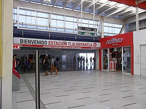
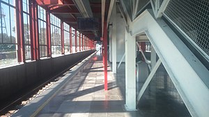
Tlalnepantla railway station
Distance: Approx. 1889 meters
Latitude and longitude: 19.53663889,-99.18394444
Tlalnepantla is a commuter railway station serving the Ferrocarril Suburbano, a suburban rail that connects the State of Mexico with Mexico City. The station is located in the municipality of Tlalnepantla, State of Mexico, north of Mexico City.
Weather in this IP's area
light rain
25 Celsius
24 Celsius
23 Celsius
25 Celsius
1011 hPa
44 %
1011 hPa
782 hPa
10000 meters
4.12 m/s
60 degree
75 %
06:24:32
18:38:19