Country:
 Mexico
Region:
City:
Latitude and Longitude:
Time Zone:
Postal Code:
IP information under different IP Channel
ip-api
Country
Region
City
ASN
Time Zone
ISP
Blacklist
Proxy
Latitude
Longitude
Postal
Route
IPinfo
Country
Region
City
ASN
Time Zone
ISP
Blacklist
Proxy
Latitude
Longitude
Postal
Route
MaxMind
Country
Region
City
ASN
Time Zone
ISP
Blacklist
Proxy
Latitude
Longitude
Postal
Route
Luminati
Country
MXRegion
cmx
City
azcapotzalco
ASN
Time Zone
America/Mexico_City
ISP
Mega Cable, S.A. de C.V.
Latitude
Longitude
Postal
db-ip
Country
Region
City
ASN
Time Zone
ISP
Blacklist
Proxy
Latitude
Longitude
Postal
Route
ipdata
Country
Region
City
ASN
Time Zone
ISP
Blacklist
Proxy
Latitude
Longitude
Postal
Route
Popular places and events near this IP address

Azcapotzalco
Borough in Mexico City, Mexico
Distance: Approx. 1527 meters
Latitude and longitude: 19.47222222,-99.18333333
Azcapotzalco (Classical Nahuatl: Āzcapōtzalco Nahuatl pronunciation: [aːskapoːˈt͡saɬko] , Spanish pronunciation: [askapoˈtsalko] , from āzcapōtzalli “anthill” + -co “place”; literally, “In the place of the anthills”) is a borough (demarcación territorial) in Mexico City. Azcapotzalco is in the northwestern part of Mexico City. The town began in the pre-Hispanic era and was the seat of the Tepanec dominion until the Aztec Triple Alliance overthrew it.

Ferrería/Arena Ciudad de México metro station
Mexico City metro station
Distance: Approx. 826 meters
Latitude and longitude: 19.490746,-99.173841
Ferrería/Arena Ciudad de México (; formerly Ferrería) is a station along Line 6 of the Mexico City Metro. It is located in the Azcapotzalco municipality, in the north of Mexico City. In 2019, the station had an average ridership of 23,779 passengers per day.
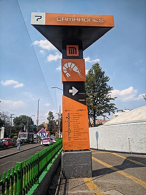
Camarones metro station
Mexico City metro station
Distance: Approx. 1327 meters
Latitude and longitude: 19.479135,-99.190063
Camarones is a station along Line 7 of the Mexico City Metro. It is located in Colonia Barrio Santa Cruz Acayucan district in the Azcapotzalco borough, north of Mexico City, Mexico. The station was opened with the others along the northern portion of Line 7 on 29 November 1988.

Norte 45 metro station
Mexico City Metro station
Distance: Approx. 1773 meters
Latitude and longitude: 19.488683,-99.162769
Norte 45 (Spanish: Estación Norte 45) is a station on Line 6 of the Mexico City Metro. It is located in the Colonia Pueblo Salinas neighborhood. The logo for this station is a compass rose and the station takes its name from a nearby street that runs from northeast to southwest (somewhat unusual for streets in Mexico City that typically run either north–south or east–west).
UAM-Azcapotzalco metro station
Mexico City metro station
Distance: Approx. 972 meters
Latitude and longitude: 19.490989,-99.186416
UAM-Azcapotzalco (; formerly Azcapotzalco) is a metro station in northern Mexico City, located in the Azcapotzalco borough, along Line 6. In 2019, the station had an average ridership of 8,076 passengers per day.

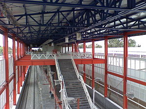
Tezozómoc metro station
Mexico City metro station
Distance: Approx. 2085 meters
Latitude and longitude: 19.495116,-99.196286
Tezozómoc is a metro station on Mexico's Line 6. It is located in the Azcapotzalco borough. In 2019, the station had an average ridership of 5,757 passengers per day.

Aquiles Serdán metro station
Mexico City metro station
Distance: Approx. 1727 meters
Latitude and longitude: 19.490423,-99.19487
Aquiles Serdán (Spanish: Estación Aquiles Serdán) is a station along Line 7 of the Mexico City Metro. It is located in the Colonia La Preciosa neighborhood of the Azcapotzalco borough of northwestern Mexico City.

Refinería metro station
Mexico City metro station
Distance: Approx. 2088 meters
Latitude and longitude: 19.469951,-99.190578
Refinería (Spanish: Estación Refinería) is a station along Line 7 of the metro of Mexico City. The station is located close to the Pemex 18 de marzo refinery in the Colonia Ángel Zimbrón neighborhood of the Azcapotzalco borough northwest of the city center, between the stations of Camarones and Tacuba. Its logo represents three containers of the Pemex refinery.
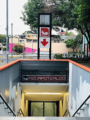
Azcapotzalco (former administrative division)
Distance: Approx. 575 meters
Latitude and longitude: 19.48611111,-99.18472222
Azcapotzalco was a Mexican municipality. It was disestablished in 1928, when the municipalities of the Federal District were replaced by boroughs (delegaciones). There is now a borough of the same name.
TecMilenio University
Mexican university system
Distance: Approx. 1736 meters
Latitude and longitude: 19.5006,-99.1756
The Universidad Tecmilenio (UTM) (Tecmilenio University) is a Mexican private university. The institution is a sister organization of the Monterrey Institute of Technology and Higher Education. The university has 30 locations and an online campus.

Jarritos
Brand of soft drink
Distance: Approx. 471 meters
Latitude and longitude: 19.48566667,-99.18377778
Jarritos is a brand of soft drink in Mexico, owned by Novamex, a large independent bottling conglomerate based in El Paso, Texas. Jarritos was founded in 1950 by Don Francisco "El Güero" Hill. Jarritos is made with fruit flavors and cane sugar, and is less carbonated than many popular soft drinks.
Fortuna railway station (Mexico City)
Distance: Approx. 1130 meters
Latitude and longitude: 19.49208333,-99.17119444
Fortuna is a commuter railway station serving the Ferrocarril Suburbano, a suburban rail that connects the State of Mexico with Mexico City. The station is located in the municipality of Azcapotzalco in the northern part of Mexico City.
Weather in this IP's area
light rain
18 Celsius
17 Celsius
18 Celsius
18 Celsius
1019 hPa
58 %
1019 hPa
788 hPa
10000 meters
3.6 m/s
350 degree
40 %
06:32:08
18:11:03