Country:
 Mexico
Region:
City:
Latitude and Longitude:
Time Zone:
Postal Code:
IP information under different IP Channel
ip-api
Country
Region
City
ASN
Time Zone
ISP
Blacklist
Proxy
Latitude
Longitude
Postal
Route
IPinfo
Country
Region
City
ASN
Time Zone
ISP
Blacklist
Proxy
Latitude
Longitude
Postal
Route
MaxMind
Country
Region
City
ASN
Time Zone
ISP
Blacklist
Proxy
Latitude
Longitude
Postal
Route
Luminati
Country
MXRegion
pue
City
pueblacity
ASN
Time Zone
America/Mexico_City
ISP
Mega Cable, S.A. de C.V.
Latitude
Longitude
Postal
db-ip
Country
Region
City
ASN
Time Zone
ISP
Blacklist
Proxy
Latitude
Longitude
Postal
Route
ipdata
Country
Region
City
ASN
Time Zone
ISP
Blacklist
Proxy
Latitude
Longitude
Postal
Route
Popular places and events near this IP address

Meritorious Autonomous University of Puebla
Public university in Puebla, Mexico
Distance: Approx. 2915 meters
Latitude and longitude: 19.000742,-98.200512
The Benemérita Universidad Autónoma de Puebla (BUAP) (Meritorious Autonomous University of Puebla) is the oldest and largest university in Puebla, Mexico. Founded on 15 April 1578 as Colegio del Espíritu Santo, the school was sponsored by the Society of Jesus during most of the Spanish colonial era before turning into a public college in 1825 and eventually into a public university in 1937. The religious origins can be seen in many of BUAP's buildings in Puebla city centre, which were once colonial-era churches.

Puebla (municipality)
Municipality in Puebla, Mexico
Distance: Approx. 4233 meters
Latitude and longitude: 19.0413,-98.2062
Puebla Municipality is a municipality in the State of Puebla in eastern Central Mexico. The municipality covers a total area of 534.32 square kilometres (206.30 sq mi). The City of Puebla is the municipal seat, as well as the capital of the state.

Universidad Popular Autónoma del Estado de Puebla
Catholic university in Puebla, Mexico
Distance: Approx. 4569 meters
Latitude and longitude: 19.0485,-98.2163
The Universidad Popular Autónoma del Estado de Puebla (UPAEP) is a private (Catholic), non-profit university located in the Mexican state of Puebla. Founded on 7 May 1973, it is currently a highly reputed university with an important national and international presence which has over 43 undergraduate programs, 34 masters programs, 12 Ph.D. programs, and 11 specializations.

Estadio Universitario BUAP
Distance: Approx. 3348 meters
Latitude and longitude: 18.99722222,-98.1975
Estadio Universitario BUAP (official name) is a multi-purpose stadium located in Ciudad Universitaria in Puebla, Puebla, Mexico. It is used by the Lobos BUAP professional football team, currently playing in the Liga MX top flight of Mexican football.
Auditorio Siglo XXI
Building
Distance: Approx. 3113 meters
Latitude and longitude: 19.0350366,-98.23684094
Auditorio Metropolitano (originally Auditorio Siglo XXI) is an indoor amphitheatre located in Puebla, Mexico. It was designed by famed Mexican architect Pedro Ramírez Vázquez.
Angelópolis Lifestyle Center
Shopping mall in Puebla, Mexico
Distance: Approx. 3361 meters
Latitude and longitude: 19.03084722,-98.20519722
Angelópolis Lifestyle Center, is an upscale shopping mall located in Puebla, Mexico. It covers more than 78,000 square meters. The mall was designed by the Sordo Madaleno group and developed as a public-private partnership.
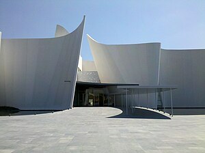
International Museum of the Baroque
Art museum in Puebla, México
Distance: Approx. 2386 meters
Latitude and longitude: 19.0193,-98.2466
The International Museum of the Baroque (Museo Internacional del Barroco, MIB) is a museum of Baroque art designed by Japanese architect Toyo Itō located in Puebla, Mexico. It opened on February 4, 2016.
Torres Médicas Angelópolis
Hospital in Puebla, Mexico
Distance: Approx. 4219 meters
Latitude and longitude: 19.01988333,-98.2652
Torres Médicas Angelópolis is a private medical center which opened in 2018 on the southwest edge of the Puebla metropolitan area. It is located next to MAC Hospital which opened a short time earlier. As of 2018, it was the largest medical construction project in the state of Puebla.

Convent Church of San Joaquín y Santa Ana, Puebla
Church in Puebla, Mexico
Distance: Approx. 4586 meters
Latitude and longitude: 19.04111111,-98.2
Iglesia de las Capuchinas, also known as Iglesia de San Joaquín y Santa Ana, is a church in the city of Puebla's historic centre, in the Mexican state of Puebla.

Convent Church of Nuestra Señora del Carmen, Puebla
Church in Mexico
Distance: Approx. 4183 meters
Latitude and longitude: 19.03805556,-98.20208333
The Conventual Temple of Our Lady of Carmen (Spanish: Templo conventual de Nuestra Señora del Carmen), currently known as the Church of the Virgin of Carmen (Spanish: Iglesia de la virgen del Carmen), is a religious temple of Catholic worship that belongs to the ecclesiastical jurisdiction of the Archdiocese of Puebla de los Ángeles, under the invocation of the Virgen del Carmen. It is an example of the Baroque architecture of Puebla from the early seventeenth century, two of its chapels are of remarkable workmanship and decoration, as is the main nave that contains paintings such as the Santísima Trinidad de Cristóbal de Villalpando and its neoclassical altarpiece that houses the image of the Virgin, the work of the sculptor José Antonio Villegas Cora. The patronal feast is celebrated on July 16.

Conservatorio de música de Puebla
Music education institution in Puebla, Mexico
Distance: Approx. 4623 meters
Latitude and longitude: 19.04651,-98.20874
The Conservatorio de música del Estado de Puebla, also known as Benemérito Conservatorio de música del Estado de Puebla, is an institution of music education that is located in the city of Puebla. The conservatory was founded on October 22, 1916.

Torre Inxignia JV
Skyscraper in Puebla, Mexico
Distance: Approx. 2432 meters
Latitude and longitude: 19.02253,-98.24479
The Torre Inxignia JV is a mixed-use skyscraper in Puebla, Mexico. Built between 2017 and 2023, the tower stands at 225 m (738 ft) with 45 floors and is the current 8th tallest building in Mexico and the tallest building in the city of Puebla. It has been serving as the headquarters of the southern filiale of BBVA México since 2024.
Weather in this IP's area
scattered clouds
22 Celsius
21 Celsius
21 Celsius
24 Celsius
1013 hPa
52 %
1013 hPa
797 hPa
10000 meters
3.67 m/s
3.56 m/s
182 degree
29 %
06:27:57
18:07:36