Country:
 Mexico
Region:
City:
Latitude and Longitude:
Time Zone:
Postal Code:
IP information under different IP Channel
ip-api
Country
Region
City
ASN
Time Zone
ISP
Blacklist
Proxy
Latitude
Longitude
Postal
Route
IPinfo
Country
Region
City
ASN
Time Zone
ISP
Blacklist
Proxy
Latitude
Longitude
Postal
Route
MaxMind
Country
Region
City
ASN
Time Zone
ISP
Blacklist
Proxy
Latitude
Longitude
Postal
Route
Luminati
Country
MXRegion
pue
City
pueblacity
ASN
Time Zone
America/Mexico_City
ISP
Mega Cable, S.A. de C.V.
Latitude
Longitude
Postal
db-ip
Country
Region
City
ASN
Time Zone
ISP
Blacklist
Proxy
Latitude
Longitude
Postal
Route
ipdata
Country
Region
City
ASN
Time Zone
ISP
Blacklist
Proxy
Latitude
Longitude
Postal
Route
Popular places and events near this IP address

Puebla (city)
Metropolis in Puebla, Mexico
Distance: Approx. 2963 meters
Latitude and longitude: 19.03333333,-98.18333333
Puebla de Zaragoza (Spanish pronunciation: [ˈpweβla]; Nahuatl languages: Cuetlaxcoapan; Mezquital Otomi: Nde'ma), formally Heroica Puebla de Zaragoza, formerly Puebla de los Ángeles during colonial times, or known simply as Puebla, is the seat of Puebla Municipality. It is the capital and largest city of the state of Puebla, and the fourth largest city in Mexico, after Mexico City, Monterrey, and Guadalajara. A viceregal era planned city, it is located in the southern part of Central Mexico on the main route between Mexico City and Mexico's main Atlantic port, Veracruz—about 100 km (62 mi) east southeast of Mexico City and about 220 km (140 mi) west of Veracruz.

Siege of Puebla (1847)
Battle in the Mexican-American War
Distance: Approx. 2963 meters
Latitude and longitude: 19.03333333,-98.18333333
Following the Battle of Chapultepec, Santa Anna withdrew his forces from Mexico City, leading a portion in an attempt to take Puebla and cut off Scott's supply route from Veracruz. The siege of Puebla began the same day Mexico City fell to Winfield Scott and lasted for 28 days: 329 before a relief force fought its way into the city.

Meritorious Autonomous University of Puebla
Public university in Puebla, Mexico
Distance: Approx. 1248 meters
Latitude and longitude: 19.000742,-98.200512
The Benemérita Universidad Autónoma de Puebla (BUAP) (Meritorious Autonomous University of Puebla) is the oldest and largest university in Puebla, Mexico. Founded on 15 April 1578 as Colegio del Espíritu Santo, the school was sponsored by the Society of Jesus during most of the Spanish colonial era before turning into a public college in 1825 and eventually into a public university in 1937. The religious origins can be seen in many of BUAP's buildings in Puebla city centre, which were once colonial-era churches.

Estadio Universitario BUAP
Distance: Approx. 1346 meters
Latitude and longitude: 18.99722222,-98.1975
Estadio Universitario BUAP (official name) is a multi-purpose stadium located in Ciudad Universitaria in Puebla, Puebla, Mexico. It is used by the Lobos BUAP professional football team, currently playing in the Liga MX top flight of Mexican football.
Angelópolis Lifestyle Center
Shopping mall in Puebla, Mexico
Distance: Approx. 2953 meters
Latitude and longitude: 19.03084722,-98.20519722
Angelópolis Lifestyle Center, is an upscale shopping mall located in Puebla, Mexico. It covers more than 78,000 square meters. The mall was designed by the Sordo Madaleno group and developed as a public-private partnership.
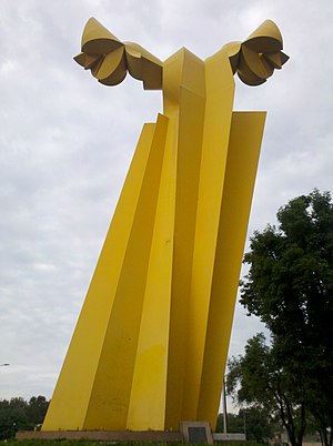
Ángel Custodio
Sculpture in Puebla, Mexico
Distance: Approx. 3713 meters
Latitude and longitude: 19.04111111,-98.19313889
Ángel Custodio is an outdoor sculpture by Sebastián (Enrique Carbajal), installed in Puebla, in the Mexican state of Puebla. It was inaugurated on November 7, 2003, during the municipal administration of Luis Eduardo Paredes Moctezuma. The sculpture is 17 meters high and is made of iron with a yellow color that comes from acrylic enamel with bronze.

Church of Nuestra Señora de la Luz, Puebla
Church in Puebla, Mexico
Distance: Approx. 3680 meters
Latitude and longitude: 19.04083333,-98.19
Iglesia de Nuestra Señora de la Luz, or simply Iglesia de la Luz, is an historic church in the city of Puebla, in the Mexican state of Puebla.

Puente de Ovando
Bridge in Puebla, Mexico
Distance: Approx. 3639 meters
Latitude and longitude: 19.04044444,-98.19311111
The Puente de Ovando (English: Ovando Bridge) is a historic bridge in the city of Puebla, in the Mexican state of Puebla.

Church of Analco, Puebla
Church in Puebla, Mexico
Distance: Approx. 3452 meters
Latitude and longitude: 19.03877778,-98.19277778
The Church of the Santo Ángel Custodio de Analco, commonly called the Church of Analco, is a Roman Catholic church under the jurisdiction of the Archdiocese of Puebla de los Ángeles and dedicated to the Holy Guardian Angel (Spanish: Santo Ángel de la Guarda) of Puebla. It is located in Analco, one of Puebla's oldest neighborhoods with a large indigenous population.
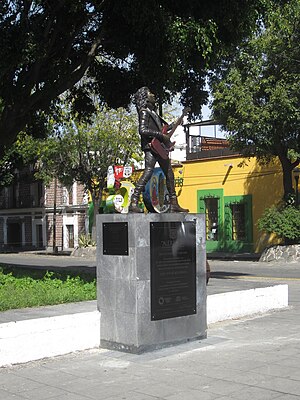
Statue of Álex Lora
Statue in Puebla, Mexico
Distance: Approx. 3588 meters
Latitude and longitude: 19.04002778,-98.19202778
The statue of Álex Lora is installed in the city of Puebla, in the Mexican state of Puebla.

Barrio de los Sapos
Tourist attraction in Puebla, Mexico
Distance: Approx. 3716 meters
Latitude and longitude: 19.04083333,-98.19638889
Barrio de los Sapos, or Callejón de los Sapos (English: "alley of the frogs"), is a tourist attraction in the city of Puebla's historic center, in Puebla, Mexico.

Convent Church of Nuestra Señora del Carmen, Puebla
Church in Mexico
Distance: Approx. 3554 meters
Latitude and longitude: 19.03805556,-98.20208333
The Conventual Temple of Our Lady of Carmen (Spanish: Templo conventual de Nuestra Señora del Carmen), currently known as the Church of the Virgin of Carmen (Spanish: Iglesia de la virgen del Carmen), is a religious temple of Catholic worship that belongs to the ecclesiastical jurisdiction of the Archdiocese of Puebla de los Ángeles, under the invocation of the Virgen del Carmen. It is an example of the Baroque architecture of Puebla from the early seventeenth century, two of its chapels are of remarkable workmanship and decoration, as is the main nave that contains paintings such as the Santísima Trinidad de Cristóbal de Villalpando and its neoclassical altarpiece that houses the image of the Virgin, the work of the sculptor José Antonio Villegas Cora. The patronal feast is celebrated on July 16.
Weather in this IP's area
scattered clouds
21 Celsius
21 Celsius
21 Celsius
24 Celsius
1013 hPa
52 %
1013 hPa
796 hPa
10000 meters
3.53 m/s
3.66 m/s
174 degree
33 %
06:27:49
18:07:28