Country:
 Mexico
Region:
City:
Latitude and Longitude:
Time Zone:
Postal Code:
IP information under different IP Channel
ip-api
Country
Region
City
ASN
Time Zone
ISP
Blacklist
Proxy
Latitude
Longitude
Postal
Route
IPinfo
Country
Region
City
ASN
Time Zone
ISP
Blacklist
Proxy
Latitude
Longitude
Postal
Route
MaxMind
Country
Region
City
ASN
Time Zone
ISP
Blacklist
Proxy
Latitude
Longitude
Postal
Route
Luminati
Country
MXRegion
pue
City
pueblacity
ASN
Time Zone
America/Mexico_City
ISP
Mega Cable, S.A. de C.V.
Latitude
Longitude
Postal
db-ip
Country
Region
City
ASN
Time Zone
ISP
Blacklist
Proxy
Latitude
Longitude
Postal
Route
ipdata
Country
Region
City
ASN
Time Zone
ISP
Blacklist
Proxy
Latitude
Longitude
Postal
Route
Popular places and events near this IP address

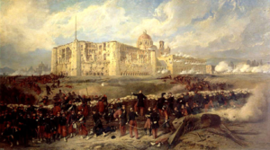
Battle of Puebla
Part of the French intervention in Mexico
Distance: Approx. 2709 meters
Latitude and longitude: 19.05,-98.2
The Battle of Puebla (Spanish: Batalla de Puebla; French: Bataille de Puebla), also known as the Battle of May 5 (Spanish: Batalla del 5 de Mayo) took place on 5 May 1862, near Puebla de los Ángeles, during the second French intervention in Mexico. French troops under the command of Charles de Lorencez repeatedly failed to storm the forts of Loreto and Guadalupe situated on top of the hills overlooking the city of Puebla, and eventually retreated to Orizaba in order to await reinforcements. Lorencez was dismissed from his command, and French troops under Élie Frédéric Forey would eventually take the city, but the Mexican victory at Puebla against a better equipped force provided patriotic inspiration to the Mexicans.

Central de Autobuses Puebla
Distance: Approx. 2154 meters
Latitude and longitude: 19.075,-98.20555556
The Central de Autobuses Puebla (CAPU) is the major bus depot in Puebla and provides access to the vast majority of Mexico through a wide range of coach companies. Due to Puebla's proximity to Mexico City there are numerous routes running from CAPU to two of the capital's major bus depots: Central de Autobuses del Norte and Central de Autobuses del Sur. Outside the main doors to CAPU is a stop for the numerous local bus routes that can take passengers all around the city as well as fleets of taxis.

Cuexcomate
Tourist attractions in Puebla
Distance: Approx. 1652 meters
Latitude and longitude: 19.07055556,-98.23527778
Cuexcomate (Spanish pronunciation: [kweɣskoˈmate]) is an inactive geyser in Puebla city, Puebla state, Mexico. The sinter cone that the geyser built up around its vent is 13 metres (43 ft) tall and has a diameter of 23 metres (75 ft). A central crater within the cone is up to 8 metres (26 ft) wide and 17 metres (56 ft) deep (extending 4 metres (13 ft) below ground level).
Colegio Americano de Puebla
Private school in Puebla, Puebla, Mexico
Distance: Approx. 1370 meters
Latitude and longitude: 19.0508,-98.2214
The Puebla American School Foundation (Spanish: Fundación Colegio Americano de Puebla) is a private school serving students in kindergarten through grade 12 in Puebla, Mexico. The school offers the International Baccalaureate Diploma and the local BUAP (Benemérita Universidad Autónoma de Puebla) for the upper school. For elementary and middle school students, the IB Primary Years and Middle Years Programme are offered.

Puebla (municipality)
Municipality in Puebla, Mexico
Distance: Approx. 2924 meters
Latitude and longitude: 19.0413,-98.2062
Puebla Municipality is a municipality in the State of Puebla in eastern Central Mexico. The municipality covers a total area of 534.32 square kilometres (206.30 sq mi). The City of Puebla is the municipal seat, as well as the capital of the state.

Universidad Popular Autónoma del Estado de Puebla
Catholic university in Puebla, Mexico
Distance: Approx. 1722 meters
Latitude and longitude: 19.0485,-98.2163
The Universidad Popular Autónoma del Estado de Puebla (UPAEP) is a private (Catholic), non-profit university located in the Mexican state of Puebla. Founded on 7 May 1973, it is currently a highly reputed university with an important national and international presence which has over 43 undergraduate programs, 34 masters programs, 12 Ph.D. programs, and 11 specializations.

Convent Church of Santo Domingo, Puebla
Church in Puebla, Mexico
Distance: Approx. 3070 meters
Latitude and longitude: 19.04694444,-98.19805556
The Convent Church of Santo Domingo de Guzmán is a Roman Catholic church within the jurisdiction of the Roman Catholic Archdiocese of Puebla de los Angeles, with the archangel Michael as its patron saint. Attached to it is the Chapel of the Rosario, an example of New Spanish Baroque, considered in its time to be the "eighth wonder of the world". The church is located in Puebla's historic centre.
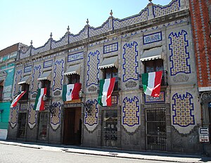
Uriarte Talavera
Distance: Approx. 2355 meters
Latitude and longitude: 19.04867222,-98.20532778
Uriarte Talavera is a traditional Talavera enterprise in the city of Puebla, Mexico, which has been in existence since 1824. It was begun as a family workshop by Dimas Uriarte, but today it is run by a business group. However, the enterprise still makes Talavera pottery using 16th century methods.
Siege of Puebla (1863)
Battle in the Second French Intervention in Mexico
Distance: Approx. 2709 meters
Latitude and longitude: 19.05,-98.2
The siege of Puebla occurred between 16 March and 17 May 1863 during the Second French intervention in Mexico, between forces of the Second French Empire and forces of the Second Federal Republic of Mexico. The French were advancing toward Mexico City, and were blocked by Mexican troops at Puebla.
Timeline of Puebla
Mexican city's timeline
Distance: Approx. 1367 meters
Latitude and longitude: 19.051389,-98.217778
The following is a timeline of the history of the city of Puebla, Mexico.
Puebla Mexico Temple
Planned temple of The Church of Jesus Christ of Latter-day Saints in Puebla, Mexico
Distance: Approx. 2821 meters
Latitude and longitude: 19.0846,-98.2359
The Puebla Mexico Temple is a temple of the Church of Jesus Christ of Latter-day Saints in Puebla, Mexico.

Conservatorio de música de Puebla
Music education institution in Puebla, Mexico
Distance: Approx. 2296 meters
Latitude and longitude: 19.04651,-98.20874
The Conservatorio de música del Estado de Puebla, also known as Benemérito Conservatorio de música del Estado de Puebla, is an institution of music education that is located in the city of Puebla. The conservatory was founded on October 22, 1916.
Weather in this IP's area
broken clouds
21 Celsius
21 Celsius
20 Celsius
23 Celsius
1013 hPa
50 %
1013 hPa
792 hPa
10000 meters
6.69 m/s
200 degree
75 %
06:27:58
18:07:33