Country:
 Mexico
Region:
City:
Latitude and Longitude:
Time Zone:
Postal Code:
IP information under different IP Channel
ip-api
Country
Region
City
ASN
Time Zone
ISP
Blacklist
Proxy
Latitude
Longitude
Postal
Route
IPinfo
Country
Region
City
ASN
Time Zone
ISP
Blacklist
Proxy
Latitude
Longitude
Postal
Route
MaxMind
Country
Region
City
ASN
Time Zone
ISP
Blacklist
Proxy
Latitude
Longitude
Postal
Route
Luminati
Country
MXRegion
oax
City
santodomingotehuantepec
ASN
Time Zone
America/Mexico_City
ISP
Mega Cable, S.A. de C.V.
Latitude
Longitude
Postal
db-ip
Country
Region
City
ASN
Time Zone
ISP
Blacklist
Proxy
Latitude
Longitude
Postal
Route
ipdata
Country
Region
City
ASN
Time Zone
ISP
Blacklist
Proxy
Latitude
Longitude
Postal
Route
Popular places and events near this IP address

Tehuantepec
City and municipality in Oaxaca, Mexico
Distance: Approx. 1568 meters
Latitude and longitude: 16.32444444,-95.23888889
Tehuantepec (Spanish pronunciation: [tewanteˈpek], in full, Santo Domingo Tehuantepec) is a city and municipality in the southeast of the Mexican state of Oaxaca. It is part of the Tehuantepec District in the west of the Istmo Region. The area was important in pre-Hispanic period as part of a trade route that connected Central America with what is now the center of Mexico.
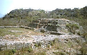
Guiengola
Distance: Approx. 9832 meters
Latitude and longitude: 16.38583333,-95.32333333
Guiengola is a Zapotec archeological site located 14 km (8.7 mi) north of Tehuantepec, and 243 km (151 mi) southeast of Oaxaca city on Federal Highway 190. The visible ruins are located between a hill and a river, each carries the name of Guiengola. The name means "large stone" in the local variant of the Zapotec language.
San Blas Atempa
Municipality and town in Oaxaca, Mexico
Distance: Approx. 4095 meters
Latitude and longitude: 16.31666667,-95.21666667
San Blas Atempa is a town and municipality in Oaxaca in south-western Mexico. The municipality covers an area of 148 square kilometres (57 sq mi). It is part of the Tehuantepec District in the west of the Istmo Region.
Santa María Mixtequilla
Municipality and town in Oaxaca, Mexico
Distance: Approx. 4181 meters
Latitude and longitude: 16.36666667,-95.25
Santa María Mixtequilla is a town and municipality in Oaxaca in south-western Mexico. The municipality covers an area of km2. It is part of the Tehuantepec District in the west of the Istmo Region.

Tehuantepec District
District in Oaxaca, Mexico
Distance: Approx. 4095 meters
Latitude and longitude: 16.31666667,-95.21666667
Tehuantepec District is located in the west of the Istmo Region of the State of Oaxaca, Mexico. It includes the cities of Salina Cruz and Tehuantepec.
Weather in this IP's area
overcast clouds
26 Celsius
26 Celsius
26 Celsius
26 Celsius
1014 hPa
69 %
1014 hPa
1008 hPa
10000 meters
5.55 m/s
14.48 m/s
356 degree
93 %
06:14:03
17:57:43