Country:
 Brazil
Region:
City:
Latitude and Longitude:
Time Zone:
Postal Code:
IP information under different IP Channel
ip-api
Country
Region
City
ASN
Time Zone
ISP
Blacklist
Proxy
Latitude
Longitude
Postal
Route
Luminati
Country
BRRegion
rs
City
pelotas
ASN
Time Zone
America/Sao_Paulo
ISP
V tal
Latitude
Longitude
Postal
IPinfo
Country
Region
City
ASN
Time Zone
ISP
Blacklist
Proxy
Latitude
Longitude
Postal
Route
db-ip
Country
Region
City
ASN
Time Zone
ISP
Blacklist
Proxy
Latitude
Longitude
Postal
Route
ipdata
Country
Region
City
ASN
Time Zone
ISP
Blacklist
Proxy
Latitude
Longitude
Postal
Route
Popular places and events near this IP address
Pelotas
Place in south Brazil
Distance: Approx. 259 meters
Latitude and longitude: -31.77194444,-52.3425
Pelotas (Portuguese pronunciation: [peˈlɔtɐs]) is a Brazilian city and municipality (município), the fourth most populous in the southern state of Rio Grande do Sul, after Porto Alegre, Caxias do Sul and Canoas. It is located 270 km (168 mi) from Porto Alegre, the state's capital city, and 130 km (80.8 mi) from the Uruguayan border. The Lagoa dos Patos lies to the east and the São Gonçalo Channel lies to the south, separating Pelotas from the city of Rio Grande.

Estádio Bento Freitas
Multi-use stadium in Pelotas, Brazil
Distance: Approx. 810 meters
Latitude and longitude: -31.77083333,-52.3325
Estádio Bento Mendes de Freitas is a multi-use stadium located in Pelotas, Brazil. It is used mostly for football matches and hosts the home matches of Grêmio Esportivo Brasil. The stadium has a maximum capacity of 18,000 people and was built in 1943.

Federal University of Pelotas
Distance: Approx. 2086 meters
Latitude and longitude: -31.7814,-52.3235
The Federal University of Pelotas (Portuguese: Universidade Federal de Pelotas, UFPEL) is a Brazilian public higher education institution, maintained by the Federal Government with administrative headquarters in the city of Pelotas, in the state of Rio Grande do Sul. It also has a campus in the city of Capão do Leão. It currently offers 94 undergraduate courses, 45 masters courses and 23 doctorate courses distributed in 22 academic units (6 Academic Centers, 4 Basic Institutes, 11 Colleges and 1 Higher School of Physical Education).
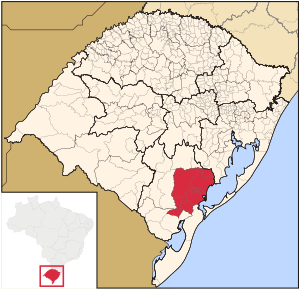
Microregion of Pelotas
Micro-region in Rio Grande do Sul, Brazil
Distance: Approx. 274 meters
Latitude and longitude: -31.77194444,-52.34277778
The Pelotas Microregion (Portuguese: Microrregião de Pelotas) is a microregion in the southeastern part of the state of Rio Grande do Sul, Brazil. The area is 10,306.601 km².

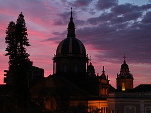
Roman Catholic Archdiocese of Pelotas
Catholic ecclesiastical territory
Distance: Approx. 727 meters
Latitude and longitude: -31.7638,-52.3386
The Archdiocese of Pelotas (Latin: Archidioecesis Pelotensis) is a Roman Catholic archdiocese located in the city of Pelotas, Rio Grande do Sul. Before being elevated to an archdiocese in its own right on April 13, 2011, it was part of the ecclesiastical province of Porto Alegre in Brazil.

Arroio Pelotas
River in Brazil
Distance: Approx. 5470 meters
Latitude and longitude: -31.76666667,-52.28333333
The Arroio Pelotas is a river of Rio Grande do Sul state in southern Brazil.
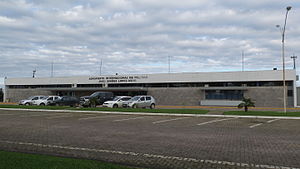
Pelotas International Airport
Airport serving Pelotas, Brazil
Distance: Approx. 6071 meters
Latitude and longitude: -31.71611111,-52.33111111
Pelotas–João Simões Lopes Neto International Airport (IATA: PET, ICAO: SBPK) is the airport serving Pelotas, Brazil. This airport was named after the regional writer João Simões Lopes Neto (1865 — 1916).

Estádio Boca do Lobo
Distance: Approx. 1092 meters
Latitude and longitude: -31.76111111,-52.33611111
Estádio Boca do Lobo is a stadium in Pelotas, Brazil. It has a capacity of 18,000 spectators. It is the home of Esporte Clube Pelotas.

Sudeste Rio-Grandense
Mesoregion in Rio Grande do Sul, Brazil
Distance: Approx. 272 meters
Latitude and longitude: -31.7719,-52.3428
Sudeste Rio-Grandense (Southeast of Rio Grande) is one of the seven Mesoregions of the state of Rio Grande do Sul in Brazil.
Weather in this IP's area
broken clouds
21 Celsius
21 Celsius
21 Celsius
21 Celsius
1018 hPa
68 %
1018 hPa
1016 hPa
10000 meters
5.14 m/s
140 degree
75 %
05:19:50
19:10:13