177.181.182.2 - IP Lookup: Free IP Address Lookup, Postal Code Lookup, IP Location Lookup, IP ASN, Public IP
Country:
Region:
City:
Location:
Time Zone:
Postal Code:
IP information under different IP Channel
ip-api
Country
Region
City
ASN
Time Zone
ISP
Blacklist
Proxy
Latitude
Longitude
Postal
Route
Luminati
Country
Region
rn
City
natal
ASN
Time Zone
America/Fortaleza
ISP
Claro NXT Telecomunicacoes Ltda
Latitude
Longitude
Postal
IPinfo
Country
Region
City
ASN
Time Zone
ISP
Blacklist
Proxy
Latitude
Longitude
Postal
Route
IP2Location
177.181.182.2Country
Region
rio grande do norte
City
vilar
Time Zone
America/Fortaleza
ISP
Language
User-Agent
Latitude
Longitude
Postal
db-ip
Country
Region
City
ASN
Time Zone
ISP
Blacklist
Proxy
Latitude
Longitude
Postal
Route
ipdata
Country
Region
City
ASN
Time Zone
ISP
Blacklist
Proxy
Latitude
Longitude
Postal
Route
Popular places and events near this IP address

Augusto Severo International Airport
Former commercial airport that served Natal, Rio Grande do Norte, Brazil
Distance: Approx. 6505 meters
Latitude and longitude: -5.90833333,-35.24916667
Augusto Severo International Airport (IATA: NAT, ICAO: SBNT), originally called Parnamirim Airport, was the civilian airport that served Natal, Brazil, located in the adjoining municipality of Parnamirim. Starting on November 24, 1951, the airport was named after the aviator Augusto Severo de Albuquerque Maranhão (1864-1902). On May 31, 2014, all domestic and international flights were moved to the new Gov.
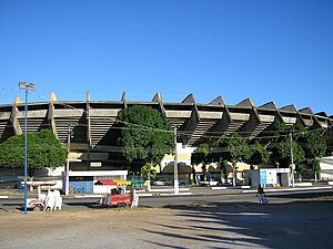
Machadão
Stadium in Natal, Brazil
Distance: Approx. 4835 meters
Latitude and longitude: -5.82562,-35.2138
Estádio Dr. João Cláudio Vasconcelos Machado, usually known as Machadão, was a multi-purpose stadium in the Brazilian city of Natal, Rio Grande do Norte. It was mostly used for football matches.

Parnamirim
Municipality in Northeast, Brazil
Distance: Approx. 7432 meters
Latitude and longitude: -5.91666667,-35.25
Parnamirim is a city in the state of Rio Grande do Norte, Brazil, next to the state capital city of Natal and part of its metropolitan area. Natal Air Force Base - ALA10, one of the most important bases of the Brazilian Air Force, is located in Parnamirim at the former Augusto Severo International Airport. The site is also home to Barreira do Inferno rocket launch base.
Midway Mall (Brazil)
Shopping mall in Rio Grande do Norte, Brazil
Distance: Approx. 6482 meters
Latitude and longitude: -5.81116,-35.2063
The Midway Mall, located in the city of Natal, is the largest shopping center in the state of Rio Grande do Norte and one of the largest in the Northeast Region if Brazil. It has a floor space of 231 acres (930,000 m2) distributed over three levels. The mall offers 300 shops, among them 13 anchor stores and seven satellite cinema multiplex network Cinemark stadiums with a capacity of 2,140 seats.
Federal University of Rio Grande do Norte
Distance: Approx. 5521 meters
Latitude and longitude: -5.83977,-35.2012
The Federal University of Rio Grande do Norte (Portuguese: Universidade Federal do Rio Grande do Norte, UFRN) is a public Brazilian university funded by the Brazilian federal government, located in the city of Natal, Rio Grande do Norte, Brazil. Formally established on December 18, 1960, it includes 60 departments providing over 70 different undergraduate courses, as well as a number of graduate programs. UFRN is the top ranked university in the state of Rio Grande do Norte, the best university in the North and Northeast region and one of the best universities in the country according to 2012 league tables.
Cemitério Morada da Paz
Cemetery in Pernambuco, Brazil
Distance: Approx. 3683 meters
Latitude and longitude: -5.8784387,-35.2331738
Cemitério Morada da Paz is a cemetery located in Natal, Brazil.

Arena das Dunas
Football stadium in Natal, Brazil
Distance: Approx. 4889 meters
Latitude and longitude: -5.826936,-35.212371
The Arena das Dunas ("Dunes Arena") is a football stadium in Natal, Brazil. It has a capacity of 31,375 spectators, and was designed by sports architect Christopher Lee of Populous. The stadium hosted football matches for the 2014 FIFA World Cup held in Brazil.

International Institute for Neuroscience of Natal
Brazilian research organization
Distance: Approx. 3996 meters
Latitude and longitude: -5.85416667,-35.21416667
The International Institute for Neurosciences of Natal - Edmond and Lily Safra (IINN-ELS - Portuguese for Instituto Internacional de Neurociências de Natal - Edmond e Lily Safra) is located in Natal, capital city of the Brazilian state of Rio Grande do Norte. It was projected and is directed by neuroscientist Miguel Nicolelis (considered one of the 20 most important neuroscientists in activity in the last decade). The IINN aims to decentralize research in Brazil, currently restricted to South and Southeast regions of Brazil.

Greater Natal
Distance: Approx. 7621 meters
Latitude and longitude: -5.795,-35.20888889
The Greater Natal (lit. Grande Natal, officially Natal Metropolitan Region, lit. Região Metropolitana de Natal) is a metropolitan area located in Rio Grande do Norte state in Brazil.

Natal City Park
Park in Natal, Rio Grande do Norte, Brazil
Distance: Approx. 2434 meters
Latitude and longitude: -5.85111111,-35.22805556
Parque da Cidade Dom Nivaldo Monte, colloquially known as Parque da Cidade, is a park in Natal, Rio Grande do Norte, Brazil. The City Park covers an area of 64 hectares, aimed at environmental preservation and education, and comprises eco-trails, jogging lanes, library, auditorium, orchidarium and more. The symbol of the Park is the central tower, 45 meter high, which houses the Memorial of the city.

Natal Air Force Base
Air base of the Brazilian Air Force
Distance: Approx. 6505 meters
Latitude and longitude: -5.90833333,-35.24916667
Natal Air Force Base – ALA10 (ICAO: SBNT) is a base of the Brazilian Air Force, located in Parnamirim, near Natal, Brazil.
TV Universitária Rio Grande do Norte
Television station in Rio Grande do Norte, Brazil
Distance: Approx. 7317 meters
Latitude and longitude: -5.81363889,-35.19488889
TV Universitária Rio Grande do Norte (channel 11, also simply known as TV Universitátia or TVU RN) is a Brazilian television station based in Natal, capital of the state of Rio Grande do Norte serving as an affiliated of TV Brasil for the entire state. Of an educational nature, it is subordinate to the Communication Superintendence (COMUNICA) of the Federal University of Rio Grande do Norte, which also includes the FM Universitária radio station and the Communication Agency (Agecom). The station's headquarters are on the UFRN university campus, in the Lagoa Nova neighborhood, and its transmission antenna is on Morro Nova Descoberta, in Parque das Dunas.
Weather in this IP's area
scattered clouds
28 Celsius
32 Celsius
27 Celsius
28 Celsius
1012 hPa
78 %
1012 hPa
1007 hPa
10000 meters
2.06 m/s
100 degree
40 %


