Country:
 Brazil
Region:
City:
Latitude and Longitude:
Time Zone:
Postal Code:
IP information under different IP Channel
ip-api
Country
Region
City
ASN
Time Zone
ISP
Blacklist
Proxy
Latitude
Longitude
Postal
Route
IPinfo
Country
Region
City
ASN
Time Zone
ISP
Blacklist
Proxy
Latitude
Longitude
Postal
Route
MaxMind
Country
Region
City
ASN
Time Zone
ISP
Blacklist
Proxy
Latitude
Longitude
Postal
Route
Luminati
Country
BRRegion
sp
City
santoandre
ASN
Time Zone
America/Sao_Paulo
ISP
TELEFONICA BRASIL S.A
Latitude
Longitude
Postal
db-ip
Country
Region
City
ASN
Time Zone
ISP
Blacklist
Proxy
Latitude
Longitude
Postal
Route
ipdata
Country
Region
City
ASN
Time Zone
ISP
Blacklist
Proxy
Latitude
Longitude
Postal
Route
Popular places and events near this IP address
Santo André, São Paulo
Municipality in Southeast, Brazil
Distance: Approx. 1785 meters
Latitude and longitude: -23.65722222,-46.53333333
Santo André (Portuguese pronunciation: [sɐ̃twɐ̃ˈdɾɛ], Saint Andrew) is a Brazilian municipality located in the Metropolitan Region of São Paulo. It is part of a group of municipalities known as the ABC Region. According to the most recent census in 2022, the population is estimated at 748,919 in an area of 175.8 km².

São Caetano do Sul
Municipality in Southeast Brazil, Brazil
Distance: Approx. 3620 meters
Latitude and longitude: -23.7,-46.55
São Caetano do Sul (or São Caetano) (Saint Cajetan of the South. Portuguese pronunciation: [sɐ̃w kajˈtɐnu du ˈsuw]) is a city in São Paulo state in Brazil. It is part of the Metropolitan Region of São Paulo.

São Bernardo do Campo
Municipality in Southeast, Brazil
Distance: Approx. 3620 meters
Latitude and longitude: -23.7,-46.55
São Bernardo do Campo (Portuguese pronunciation: [sɐ̃w beʁˈnaʁdu du ˈkɐ̃pu]) is a Brazilian municipality in the state of São Paulo. It is part of the Metropolitan Region of São Paulo. The population is 810,729 (2022 census) in an area of 409.51 km2 (158.11 sq mi).

ABC Region
Industrial region in Greater São Paulo, Brazil
Distance: Approx. 1415 meters
Latitude and longitude: -23.66583333,-46.54166667
The ABC Region is an industrial region in Greater São Paulo, Brazil. The name refers to three smaller cities south of São Paulo, capital of the Brazilian state of the same name. Originally, these three cities were Santo André, São Bernardo do Campo, and São Caetano do Sul.

Estádio Bruno José Daniel
Distance: Approx. 2181 meters
Latitude and longitude: -23.66944444,-46.50916667
The Estádio Bruno José Daniel, sometimes called Brunão or Estádio Municipal Bruno José Daniel, is a football stadium in Santo André, São Paulo state. The stadium, which opened on December 14, 1969, has a maximum capacity of 18,000 people. It is owned by the City Hall of Santo André, and is the home of Santo André.

Federal University of ABC
Public federal university in São Paulo, Brazil
Distance: Approx. 3125 meters
Latitude and longitude: -23.645,-46.528
Federal University of ABC (Portuguese: Universidade Federal do ABC, UFABC) is a Brazilian federal public institution of higher learning based in Santo André and São Bernardo do Campo, municipalities belonging to the ABC region, both in the state of São Paulo. UFABC is the only federal university in Brazil with 100% of its professors holding PhDs and, for the second consecutive year in 2011, emerged as the only university in Brazil with impact factor in scientific publications above the world average according to SCImago Institutions Rankings. The institution was evaluated by the General Course Index (IGC) of the Ministry of Education (MEC) as the best university in the State of São Paulo, being rated as the 1st in the ranking of undergraduate courses among all universities in Brazil.

Faculdade de Direito de São Bernardo do Campo
Distance: Approx. 3345 meters
Latitude and longitude: -23.6891,-46.5579
College of Law of São Bernardo do Campo (in Portuguese: Faculdade de Direito de São Bernardo do Campo (FDSBC), also known as "Direito São Bernardo") is a public institution of higher education located in São Bernardo do Campo.

ETEC Lauro Gomes
Vocational school, secondary school in São Bernardo do Campo, São Paulo, Brazil
Distance: Approx. 2140 meters
Latitude and longitude: -23.69,-46.54
ETEC Lauro Gomes, formerly known as ETE Lauro Gomes, ETI Lauro Gomes and Escola Técnica Industrial de São Bernardo do Campo is an educational facility located in São Bernardo do Campo, SP, Brazil. It offers secondary education and vocational education classes. It is named after Lauro Gomes de Almeida, mayor for São Bernardo do Campo between 1952 and 1954 and 1960 to 1963.

Sabina Escola Parque do Conhecimento
Science museum
Distance: Approx. 680 meters
Latitude and longitude: -23.67903,-46.53129
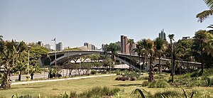
The Sabina School Park of Knowledge (Portuguese: Sabina Escola Parque do Conhecimento) is a science museum in Santo André, São Paulo, Brazil. Other planetaria in Greater São Paulo include Professor Aristóteles Orsini Planetarium and Carmo Planetarium.
Prefeito Saladino (CPTM)
Railway station in São Paulo, Brazil
Distance: Approx. 3904 meters
Latitude and longitude: -23.6384257,-46.5365893
Prefeito Saladino is a train station on CPTM Line 10-Turquoise, located in the city of Santo André.
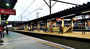
Pref. Celso Daniel-Santo André (CPTM)
Railway station in São Paulo, Brazil
Distance: Approx. 2319 meters
Latitude and longitude: -23.652244,-46.528221
Prefeito Celso Daniel-Santo André, or informally known only as Santo André, is a train station on CPTM Line 10 (Turquoise), in the city of Santo André.
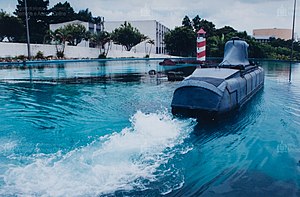
Cidade da Criança
Amusement park in Brazil
Distance: Approx. 3214 meters
Latitude and longitude: -23.687825,-46.55725833
The Cidade da Criança (Children's City) is a Brazilian amusement park located in the center of São Bernardo do Campo, in the metropolitan region of São Paulo, behind the former Vera Cruz Film Studios. It was the first theme park in Brazil and in Latin America. It opened on October 10, 1968.
Weather in this IP's area
overcast clouds
15 Celsius
15 Celsius
13 Celsius
17 Celsius
1020 hPa
95 %
1020 hPa
930 hPa
7000 meters
5.14 m/s
190 degree
100 %
06:01:33
18:00:18