Country:
 Brazil
Region:
City:
Latitude and Longitude:
Time Zone:
Postal Code:
IP information under different IP Channel
ip-api
Country
Region
City
ASN
Time Zone
ISP
Blacklist
Proxy
Latitude
Longitude
Postal
Route
IPinfo
Country
Region
City
ASN
Time Zone
ISP
Blacklist
Proxy
Latitude
Longitude
Postal
Route
MaxMind
Country
Region
City
ASN
Time Zone
ISP
Blacklist
Proxy
Latitude
Longitude
Postal
Route
Luminati
Country
BRRegion
sp
City
santoandre
ASN
Time Zone
America/Sao_Paulo
ISP
TELEFONICA BRASIL S.A
Latitude
Longitude
Postal
db-ip
Country
Region
City
ASN
Time Zone
ISP
Blacklist
Proxy
Latitude
Longitude
Postal
Route
ipdata
Country
Region
City
ASN
Time Zone
ISP
Blacklist
Proxy
Latitude
Longitude
Postal
Route
Popular places and events near this IP address
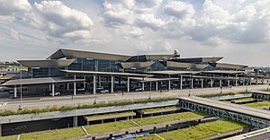
São Paulo/Guarulhos International Airport
Primary airport serving São Paulo, Brazil
Distance: Approx. 4353 meters
Latitude and longitude: -23.43555556,-46.47305556
São Paulo/Guarulhos–Governor André Franco Montoro International Airport (IATA: GRU, ICAO: SBGR), commonly known as São Paulo/Guarulhos International Airport, is the primary international airport serving São Paulo. It is popularly known locally as either Cumbica Airport, after the district where it is located and the Brazilian Air Force base that exists at the airport complex, or Guarulhos Airport, after the municipality of Guarulhos, in the state of São Paulo, where it is located. Since November 28, 2001, the airport has been named after André Franco Montoro (1916–1999), former Governor of São Paulo state.
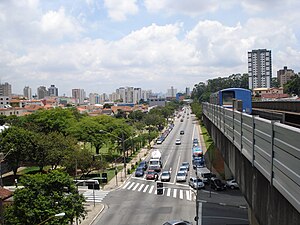
Tucuruvi
District of São Paulo, Brazil
Distance: Approx. 7757 meters
Latitude and longitude: -23.48111112,-46.4313889
Tucuruvi is a district located in the North Zone of the municipality of São Paulo, Brazil.
Baquirivu-Guaçu River
River in Brazil
Distance: Approx. 9150 meters
Latitude and longitude: -23.48333333,-46.48333333
The Baquirivu-Guaçu River is a river of São Paulo state in southeastern Brazil.
Subprefecture of Ermelino Matarazzo
Subprefecture in Southeast, Brazil
Distance: Approx. 9341 meters
Latitude and longitude: -23.48944444,-46.47388889
The Subprefecture of Ermelino Matarazzo is one of 32 subprefectures of the city of São Paulo, Brazil. It comprises two districts: Ermelino Matarazzo and Ponte Rasa. It hosts the second largest campus of University of São Paulo in the city.

Subprefecture of São Miguel Paulista
Subprefecture in Southeast, Brazil
Distance: Approx. 7842 meters
Latitude and longitude: -23.48222222,-46.44111111
The Subprefecture of São Miguel Paulista is one of 32 subprefectures of the city of São Paulo, Brazil. It comprises three districts: São Miguel Paulista, Jardim Helena, and Vila Jacuí.
Ermelino Matarazzo (district of São Paulo)
District of São Paulo, Brazil
Distance: Approx. 9052 meters
Latitude and longitude: -23.4887,-46.468
Ermelino Matarazzo is one of 96 districts in the city of São Paulo, Brazil.

Jardim Helena
District of São Paulo, Brazil
Distance: Approx. 7831 meters
Latitude and longitude: -23.4802,-46.4213
Jardim Helena is one of 96 districts in the city of São Paulo, Brazil.

Guarulhos-CECAP (CPTM)
Railway station in São Paulo, Brazil
Distance: Approx. 6882 meters
Latitude and longitude: -23.448611,-46.493333
Guarulhos-CECAP is a train station on CPTM Line 13-Jade, located in the district of Cecap in Guarulhos. It is located by the Km 3 of Rodovia Hélio Smidt, next to Parque Cecap. It has connection with Guarulhos Road Terminal.

Aeroporto–Guarulhos (CPTM)
Railway station in São Paulo, Brazil
Distance: Approx. 5989 meters
Latitude and longitude: -23.433056,-46.493056
Aeroporto–Guarulhos is a train station on CPTM Line 13-Jade, located in the district of Parque Cecap in Guarulhos. It has connections with the North EMTU Corridor, through Taboão Bus Terminal, and with the Governor André Franco Montoro Airport. The station is in the left side of Rodovia Hélio Smidt and will be connected with a people mover, operated by GRU Airport, which will connect the station with terminals 1, 2 and 3.

São Miguel Paulista (CPTM)
Train station in the city of São Paulo
Distance: Approx. 8779 meters
Latitude and longitude: -23.490633,-46.441644
São Miguel Paulista is a train station belonging to CPTM Line 12-Sapphire, located in the city of São Paulo.
Jardim Helena-Vila Mara (CPTM)
Railway station in São Paulo, Brazil
Distance: Approx. 9195 meters
Latitude and longitude: -23.492719,-46.4211309
Jardim Helena-Vila Mara is a train station on CPTM Line 12-Sapphire, located in the district of Vila Curuçá, a few meters of the district of Jardim Helena (north side), being built to facilitate the access of passengers of both neighbourhoods, located in the city of São Paulo.

São Paulo Air Force Base
Air base of the Brazilian Air Force
Distance: Approx. 4353 meters
Latitude and longitude: -23.43555556,-46.47305556
Base Aérea de São Paulo – BASP (IATA: GRU, ICAO: SBGR) is a base of the Brazilian Air Force, located in Guarulhos, Brazil. It shares some facilities with Gov. André Franco Montoro International Airport.
Weather in this IP's area
overcast clouds
17 Celsius
17 Celsius
15 Celsius
17 Celsius
1021 hPa
88 %
1021 hPa
936 hPa
10000 meters
2.06 m/s
200 degree
100 %
06:01:09
17:59:59