Country:
 Brazil
Region:
City:
Latitude and Longitude:
Time Zone:
Postal Code:
IP information under different IP Channel
ip-api
Country
Region
City
ASN
Time Zone
ISP
Blacklist
Proxy
Latitude
Longitude
Postal
Route
IPinfo
Country
Region
City
ASN
Time Zone
ISP
Blacklist
Proxy
Latitude
Longitude
Postal
Route
MaxMind
Country
Region
City
ASN
Time Zone
ISP
Blacklist
Proxy
Latitude
Longitude
Postal
Route
Luminati
Country
BRRegion
sp
City
francodarocha
ASN
Time Zone
America/Sao_Paulo
ISP
IWNET TELECOM LTDA ME
Latitude
Longitude
Postal
db-ip
Country
Region
City
ASN
Time Zone
ISP
Blacklist
Proxy
Latitude
Longitude
Postal
Route
ipdata
Country
Region
City
ASN
Time Zone
ISP
Blacklist
Proxy
Latitude
Longitude
Postal
Route
Popular places and events near this IP address
Caieiras
Municipality in the state of São Paulo in Brazil
Distance: Approx. 4955 meters
Latitude and longitude: -23.36444444,-46.74083333
Caieiras is a municipality in the state of São Paulo in Brazil. It is part of the Metropolitan Region of São Paulo. The population is 102,775 (2020 est.) in an area of 97.64 km2.

Francisco Morato
Municipality in Southeast Brazil, Brazil
Distance: Approx. 4944 meters
Latitude and longitude: -23.28166667,-46.7425
Francisco Morato is a suburban city in the state of São Paulo in Brazil. It is part of the Metropolitan Region of São Paulo. The population is 177,633 (2020 est.) in an area of 49.00 km2 (18.92 sq mi).

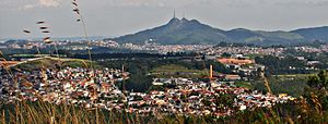
Franco da Rocha
Municipality in Southeast Brazil, São Paulo
Distance: Approx. 660 meters
Latitude and longitude: -23.32861111,-46.72444444
Franco da Rocha is a municipality in the state of São Paulo. It is part of the Metropolitan Region of São Paulo. The population is 156,492 (2020 est.) in an area of 132.78 km2.

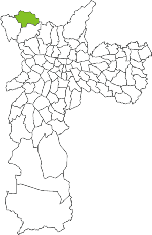
Subprefecture of Perus
Subprefecture in Southeast, Brazil
Distance: Approx. 10004 meters
Latitude and longitude: -23.41,-46.74722222
The Subprefecture of Perus is one of 32 subprefectures of the city of São Paulo, Brazil. It comprises two districts: Anhanguera and Perus.

Sistema Cantareira
Distance: Approx. 4682 meters
Latitude and longitude: -23.33,-46.67888889
Sistema Cantareira (Cantareira system) is a water supply system in the state of São Paulo, Brazil. It is composed of five interconnected reservoirs that provide water to 9 million people in the São Paulo metropolitan area. The system is managed by Sabesp, São Paulo's state water management company.
Perus (district of São Paulo)
District of São Paulo, Brazil
Distance: Approx. 9648 meters
Latitude and longitude: -23.4044,-46.7555
Perus is one of 96 districts in the city of São Paulo, Brazil. The Perus-Pirapora Railway passes there.

Juqueri State Park
Distance: Approx. 4544 meters
Latitude and longitude: -23.353444,-46.69475
The Juqueri State Park (Portuguese: Parque Estadual do Juqueri) is a state park in the state of São Paulo, Brazil. It protects one of the last remnants of cerrado in the São Paulo metropolitan region, as well as areas of Atlantic Forest. In August 2021 a fire burnt half of the Land of the park.
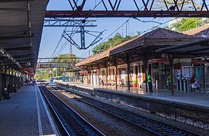
Caieiras (CPTM)
Railway station in São Paulo, Brazil
Distance: Approx. 5530 meters
Latitude and longitude: -23.365805,-46.75089
Caieiras is a train station on CPTM Line 7-Ruby, located in Caieiras.

Baltazar Fidélis (CPTM)
Railway station in São Paulo, Brazil
Distance: Approx. 1462 meters
Latitude and longitude: -23.309582,-46.723269
Baltazar Fidélis is a train station on CPTM Line 7-Ruby, located in the district of Vila Bela in Franco da Rocha.

Francisco Morato (CPTM)
Railway station in São Paulo, Brazil
Distance: Approx. 4925 meters
Latitude and longitude: -23.281723,-46.742168
Francisco Morato is a train station on CPTM Line 7-Ruby, located in Francisco Morato.
Weather in this IP's area
clear sky
20 Celsius
19 Celsius
19 Celsius
21 Celsius
1015 hPa
54 %
1015 hPa
931 hPa
10000 meters
1.62 m/s
2.97 m/s
28 degree
05:46:50
18:05:50