Country:
 Brazil
Region:
City:
Latitude and Longitude:
Time Zone:
Postal Code:
IP information under different IP Channel
ip-api
Country
Region
City
ASN
Time Zone
ISP
Blacklist
Proxy
Latitude
Longitude
Postal
Route
IPinfo
Country
Region
City
ASN
Time Zone
ISP
Blacklist
Proxy
Latitude
Longitude
Postal
Route
MaxMind
Country
Region
City
ASN
Time Zone
ISP
Blacklist
Proxy
Latitude
Longitude
Postal
Route
Luminati
Country
BRASN
Time Zone
America/Sao_Paulo
ISP
TELECOMUNICACOES BRASILEIRAS S. A. - TELEBRAS
Latitude
Longitude
Postal
db-ip
Country
Region
City
ASN
Time Zone
ISP
Blacklist
Proxy
Latitude
Longitude
Postal
Route
ipdata
Country
Region
City
ASN
Time Zone
ISP
Blacklist
Proxy
Latitude
Longitude
Postal
Route
Popular places and events near this IP address
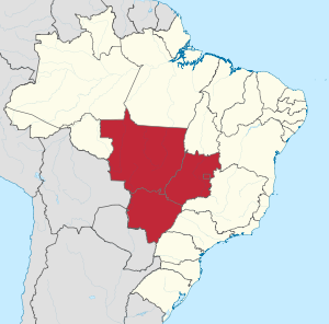
Central-West Region, Brazil
Region in Brazil
Distance: Approx. 2377 meters
Latitude and longitude: -15.77972222,-47.93055556
The Central-West or Center-West Region of Brazil (Portuguese: Região Centro-Oeste do Brasil [ʁeʒiˈɐ̃w ˌsẽtɾoˈɛstʃi du bɾaˈziw]) is composed of the states of Goiás, Mato Grosso and Mato Grosso do Sul; along with Distrito Federal (Federal District), where Brazil's national capital, Brasília, is situated. The region comprises 18.86% of the national territory, and is the least populated in Brazil. With the move of the country's federal capital from Rio de Janeiro to Brasília in the 1960s, the construction of roads and railways to the interior of the country made access to the region easier, speeding up population growth and contributing significantly to the region's development.

Estádio Nacional Mané Garrincha
Football stadium and multipurpose arena in Brasília, DF, Brazil
Distance: Approx. 2295 meters
Latitude and longitude: -15.7835,-47.89916389
Arena BRB Mané Garrincha, formerly Estádio Nacional de Brasília Mané Garrincha, also known as Estádio Nacional Mané Garrincha, Estádio Nacional de Brasília, or simply Mané Garrincha, is a football stadium and multipurpose arena, located in Brasília, in the Distrito Federal. The stadium is one of several structures that make up Brasília's Ayrton Senna Sports Complex. Since 2019, the stadium and its surroundings - including the Nilson Nelson Gymnasium - are under private administration.
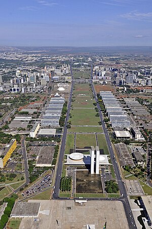
Monumental Axis
Avenue in Distrito Federal, Brazil
Distance: Approx. 1684 meters
Latitude and longitude: -15.78694444,-47.90361111
The Monumental Axis (Portuguese: Eixo Monumental) is the central and main avenue in Brasília's city design. The avenue begins on the National Congress of Brazil building and is considered part of the DF-002 road. Its first section is known as "Ministries Esplanade" ("Esplanada dos Ministérios"), as it is surrounded by ministries buildings.

Brasília TV Tower
Observation tower Broadcasting tower in Brasília, Brazil
Distance: Approx. 2562 meters
Latitude and longitude: -15.790499,-47.892977
The Brasília TV Tower (Portuguese: Torre de TV de Brasília) is a radio and television transmission tower built in Brasilia and inaugurated in 1967 with a height of 224 meters. It is located at the Monumental Axis, in the Burle Marx Garden, and besides the tower itself, which has a belvedere and a museum, the Museum of Gems, its immediate surroundings have several attractions, such as the Fair Tower and the TV Tower Fountain, which makes the place one of the most visited by tourists, receiving from ten to twelve thousand people a week. The tower originally had a height of 218 metres.

Roman Catholic Archdiocese of Brasília
Catholic ecclesiastical territory in Brazil
Distance: Approx. 2238 meters
Latitude and longitude: -15.7833,-47.9
The Metropolitan Archdiocese of Brasília (Latin: Archidioecesis Metropolitae Brasiliapolitanus) is ecclesiastical territory or archdiocese of the Latin Church of the Catholic Church located in the city of Brasília in Brazil. The archdiocese is a metropolitan see.

Nilson Nelson Gymnasium
Distance: Approx. 2015 meters
Latitude and longitude: -15.78305556,-47.90305556
The Nilson Nelson Gymnasium (Ginásio Nilson Nelson) is an indoor sporting arena used mostly for volleyball located in Brasília, Brazil, which is near the Estádio Nacional Mané Garrincha. Both are part of the Ayrton Senna Sports Complex. The capacity of the arena is 11,105 spectators and it was built in 1973.
American School of Brasília
Private school in Brasília, DF, Brazil
Distance: Approx. 1791 meters
Latitude and longitude: -15.8,-47.9
Escola Americana de Brasília (American School of Brasília or EAB) provides a US and Brazilian accredited pre-K through twelfth grade curriculum. EAB is an English-language school operated using American-style teaching. The school is open to students of all nationalities.
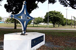
Cruzeiro, Federal District
Administrative region in Central-West, Brazil
Distance: Approx. 2324 meters
Latitude and longitude: -15.79083333,-47.93722222
Cruzeiro (Portuguese pronunciation: [kɾuˈzei.ɾu]) is an administrative region in the Federal District in Brazil. It is bordered by SIA and Brasília to the north, and Sudoeste/Octogonal to the southeast. Created in 1959, Cruzeiro is divided into two broad sections: the original town, Cruzeiro Velho, made up mostly of one- and two-story houses, and Cruzeiro Novo, made up of several similar four-story buildings since 1970.

JK Memorial
Museum, memorial, mausoleum in Eixo Monumental, Brasília
Distance: Approx. 1315 meters
Latitude and longitude: -15.7842063,-47.9155431
The JK Memorial is a mausoleum, presidential memorial and museum dedicated to Juscelino Kubitschek (1902–1976), the 21st President of Brazil and the founder of Brasília, capital city of Brazil since 1960. Designed by Oscar Niemeyer, the memorial is located in the Monumental Axis in Brasília. It is the final resting place of President Kubitschek.
Sudoeste/Octogonal
Administrative region in Central-West, Brazil
Distance: Approx. 977 meters
Latitude and longitude: -15.80027778,-47.92416667
Sudoeste/Octogonal is an administrative region in the Federal District in Brazil. It is largely surrounded by Brasília to the east, and bordered by SIA and Cruzeiro to the west. Sudoeste/Octogonal was founded on July 10, 1989, receiving the status of administrative region, according to Law 3153, of May 6, 2003.
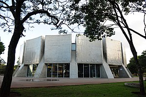
Brasília Planetarium
Building in Brasília
Distance: Approx. 2071 meters
Latitude and longitude: -15.7877,-47.8989
The Brasília Planetarium Luiz Cruls (Portuguese: Planetário de Brasília Luiz Cruls, lit. 'Planetarium of Brasília Luiz Cruls'), colloquially known as the Brasília Planetarium or the Planetarium of Brasília, is a planetarium located in Brasília, in the Federal District. Inaugurated on 15 March 1974, it was designed by architect Sérgio Bernandes using a Brutalist style. It is part of the Monumental Axis' Cultural Diffusion Sector (Portuguese: Setor de Difusão Cultural), being located between the Brasília TV Tower, the Ulysses Guimarães Convention Center, and near the Estádio Nacional Mané Garrincha and the Brasília Choro Club.
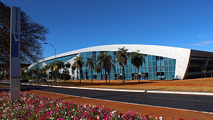
Ulysses Guimarães Convention Center
Convention center in Brasília - DF, Brazil
Distance: Approx. 1883 meters
Latitude and longitude: -15.7882,-47.9006
The Ulysses Guimarães Convention Center (Portuguese: Centro de Convenções Ulysses Guimarães, CCUG), formerly the Brasília Convention Center (Portuguese: Centro de Convenções de Brasília) is a convention center located in Brasília. It was designed by Sérgio Bernandes in 1973 and was inaugurated on 12 March 1979, being refurbished in 2005. It was renamed in 1992 to honor Ulysses Guimarães.
Weather in this IP's area
clear sky
19 Celsius
18 Celsius
19 Celsius
19 Celsius
1012 hPa
55 %
1012 hPa
888 hPa
10000 meters
1.54 m/s
250 degree
05:53:01
18:08:32