Country:
 Brazil
Region:
City:
Latitude and Longitude:
Time Zone:
Postal Code:
IP information under different IP Channel
ip-api
Country
Region
City
ASN
Time Zone
ISP
Blacklist
Proxy
Latitude
Longitude
Postal
Route
IPinfo
Country
Region
City
ASN
Time Zone
ISP
Blacklist
Proxy
Latitude
Longitude
Postal
Route
MaxMind
Country
Region
City
ASN
Time Zone
ISP
Blacklist
Proxy
Latitude
Longitude
Postal
Route
Luminati
Country
BRRegion
rj
City
riodejaneiro
ASN
Time Zone
America/Sao_Paulo
ISP
TIM SA
Latitude
Longitude
Postal
db-ip
Country
Region
City
ASN
Time Zone
ISP
Blacklist
Proxy
Latitude
Longitude
Postal
Route
ipdata
Country
Region
City
ASN
Time Zone
ISP
Blacklist
Proxy
Latitude
Longitude
Postal
Route
Popular places and events near this IP address
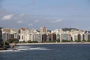
Niterói
Municipality in Southeast, Brazil
Distance: Approx. 4699 meters
Latitude and longitude: -22.88333333,-43.10361111
Niterói (Portuguese pronunciation: [niteˈɾɔj]) is a municipality in the state of Rio de Janeiro, in the southeast region of Brazil. It lies across Guanabara Bay, facing the city of Rio de Janeiro and forming part of the Rio de Janeiro Metropolitan Area. It was the capital of Rio de Janeiro, as marked by its golden mural crown, from 1834 to 1894 and again from 1903 to 1975.
Camboinhas
Distance: Approx. 5876 meters
Latitude and longitude: -22.96377,-43.0489
Camboinhas is one of the 48 neighborhoods into which the city of Niterói, in Brazil, is divided. The name originated in a marine accident in the 1950s. In that decade, a ship called Camboinhas grounded on the beach.

Charitas
Neighbourhood of Niterói, Brazil
Distance: Approx. 1699 meters
Latitude and longitude: -22.92804,-43.09525
Charitas is one of the 48 neighborhoods in which the city of Niterói, in Brazil is divided. The area was part of the Jesuitic Sesmaria, where the Jesuits built a cemetery and a church consecrated to Saint Francis Xavier. The name of the neighborhood derives from the Latin word caritas, meaning charity, which is inscribed on the church's door.

São Francisco, Niterói
Distance: Approx. 914 meters
Latitude and longitude: -22.91735,-43.0895
São Francisco is one of the 48 neighborhoods in which the Brazilian city of Niterói is divided. As of 2000, its population was 9,654. Its name derives from the church consecrated to Saint Francis Xavier (in Portuguese: São Francisco Xavier) and references to it can be found as early as the 17th century.

Fluminense Federal University
Public university in Niterói, Brazil
Distance: Approx. 4055 meters
Latitude and longitude: -22.90416667,-43.11666667
The Fluminense Federal University (Portuguese: Universidade Federal Fluminense, UFF, named after the state's demonym) is a Brazilian public higher education institution located mainly in Niterói and in other cities of Rio de Janeiro state. It was first established on December 18, 1960, with the name of Universidade Federal do Estado do Rio de Janeiro (UFERJ), through an integration of different academic colleges in the city of Niterói. On November 5, 1965, the current name became official.
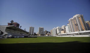
Estádio Caio Martins
Distance: Approx. 3341 meters
Latitude and longitude: -22.90055556,-43.10583333
Estádio Caio Martins, sometimes called Estádio Mestre Ziza, is a football stadium in Niterói, Rio de Janeiro state, Brazil. The stadium holds 12,000 people. It was built in 1941.
Baldeador
Distance: Approx. 5240 meters
Latitude and longitude: -22.87666667,-43.06138889
Baldeador is one of the 48 administrative districts in which the city of Niterói, Rio de Janeiro in Brazil is divided. It lies in the northern zone of the city, bordering the municipality of São Gonçalo. Its name derives from the Portuguese word for railway junction.
Jurujuba
Distance: Approx. 3933 meters
Latitude and longitude: -22.93333333,-43.11666667
Jurujuba is a promontory and one of the 48 administrative districts of Niterói, Rio de Janeiro, Brazil. It is located in the southern zone of the city, situated on the coast of the Guanabara Bay.
Gragoatá
Distance: Approx. 5805 meters
Latitude and longitude: -22.9,-43.13333333
Gragoatá is one of the 48 administrative districts in the city Niterói, Rio de Janeiro in Brazil. It lies in the southern zone of the city, on the coast of the Guanabara Bay. It holds the main campus of the Fluminense Federal University.

Roman Catholic Archdiocese of Niterói
Latin Catholic territory in Brazil
Distance: Approx. 5136 meters
Latitude and longitude: -22.8915,-43.1204
The Archdiocese of Niteroi (Nictheroy) (Latin: Archidioecesis Nictheroyensis) is a Latin Church ecclesiastical territory or archdiocese of the Catholic Church in the city of Niterói in Rio de Janeiro state, southeast Brazil. It is a metropolitan see. Its cathedral archiepiscopal see is Metropolitan Cathedral of St.
Cubango, Niterói
Human settlement in Brazil
Distance: Approx. 3627 meters
Latitude and longitude: -22.891,-43.097
See Cubango for namesakes, notably in Africa Cubango is a neighborhood located in the northwest of the city Niterói, Rio de Janeiro (state), Brazil. It is famous for hosting the samba school Acadêmicos do Cubango that competes in the Rio Carnival.
Metropolitan Cathedral of St. John the Baptist, Niterói
Church in Niterói, Brazil
Distance: Approx. 5138 meters
Latitude and longitude: -22.89153056,-43.12045
The Metropolitan Cathedral of St. John the Baptist (Portuguese: Catedral Metropolitana São João Batista) Also Niterói Cathedral It is a Catholic cathedral built in late colonial style in the city of Niterói, in the state of Rio de Janeiro in the south of Brazil. It is located in Jardim São João, set of landscaped squares in the historical center of the city.
Weather in this IP's area
overcast clouds
22 Celsius
22 Celsius
21 Celsius
22 Celsius
1021 hPa
78 %
1021 hPa
995 hPa
10000 meters
6.17 m/s
12.35 m/s
210 degree
100 %
05:47:38
17:46:38