Country:
 Brazil
Region:
City:
Latitude and Longitude:
Time Zone:
Postal Code:
IP information under different IP Channel
ip-api
Country
Region
City
ASN
Time Zone
ISP
Blacklist
Proxy
Latitude
Longitude
Postal
Route
Luminati
Country
BRRegion
rj
City
belfordroxo
ASN
Time Zone
America/Sao_Paulo
ISP
IPGLOBE INTERNET LTDA
Latitude
Longitude
Postal
IPinfo
Country
Region
City
ASN
Time Zone
ISP
Blacklist
Proxy
Latitude
Longitude
Postal
Route
db-ip
Country
Region
City
ASN
Time Zone
ISP
Blacklist
Proxy
Latitude
Longitude
Postal
Route
ipdata
Country
Region
City
ASN
Time Zone
ISP
Blacklist
Proxy
Latitude
Longitude
Postal
Route
Popular places and events near this IP address
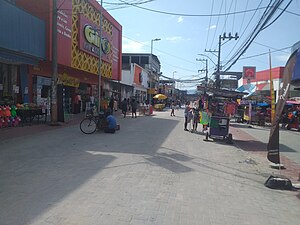
Belford Roxo, Rio de Janeiro
Municipality in Southeast, Brazil
Distance: Approx. 7292 meters
Latitude and longitude: -22.76388889,-43.39888889
Belford Roxo (Portuguese pronunciation: [ˈbɛwfɔʁ ˈʁoʃu]) is a city in the state of Rio de Janeiro, Brazil. It is a part of the metropolitan region of the city of Rio de Janeiro and was created in 1990. Its population was 513,118 in 2020 and its area is 79 km².
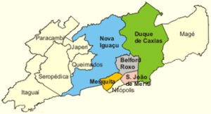
Baixada Fluminense
Distance: Approx. 9678 meters
Latitude and longitude: -22.75972222,-43.44277778
The Baixada Fluminense (standard Portuguese pronunciation: [ˌbajˈʃadɐ flumiˈnẽjsi]; local pronounce: [ˌbɐ(j)ˈʃadɐ flumɪˈnẽ(j)si]) (literally "Fluminense Lowland") is a region in the state of Rio de Janeiro, in southeastern Brazil. It is located on Guanabara Bay, between Rio de Janeiro to the south and the Serra dos Órgãos range of hills to the north. Its municipalities are part of the Rio de Janeiro Metropolitan Region.
Botas River
River in Brazil
Distance: Approx. 2157 meters
Latitude and longitude: -22.7,-43.35
The Botas River is a river of Rio de Janeiro state in southeastern Brazil.

Capivari River (Rio de Janeiro)
River in Brazil
Distance: Approx. 3850 meters
Latitude and longitude: -22.7,-43.33333333
The Capivari River is a river of Rio de Janeiro state in southeastern Brazil. It is a tributary of the Iguaçu River.
Tinguá River
River in Brazil
Distance: Approx. 6707 meters
Latitude and longitude: -22.65,-43.4
The Tinguá River is a river of Rio de Janeiro state in southeastern Brazil.

Vila Medeiros
District of São Paulo, Brazil
Distance: Approx. 5963 meters
Latitude and longitude: -22.75,-43.4
Vila Medeiros is a district located in the northeastern district of the city of São Paulo.
Weather in this IP's area
broken clouds
22 Celsius
22 Celsius
22 Celsius
22 Celsius
1013 hPa
83 %
1013 hPa
1013 hPa
8000 meters
1.54 m/s
10 degree
75 %
05:00:50
18:17:56