Country:
 Brazil
Region:
City:
Latitude and Longitude:
Time Zone:
Postal Code:
IP information under different IP Channel
ip-api
Country
Region
City
ASN
Time Zone
ISP
Blacklist
Proxy
Latitude
Longitude
Postal
Route
IPinfo
Country
Region
City
ASN
Time Zone
ISP
Blacklist
Proxy
Latitude
Longitude
Postal
Route
MaxMind
Country
Region
City
ASN
Time Zone
ISP
Blacklist
Proxy
Latitude
Longitude
Postal
Route
Luminati
Country
BRRegion
to
City
palmas
ASN
Time Zone
America/Araguaina
ISP
TELEFONICA BRASIL S.A
Latitude
Longitude
Postal
db-ip
Country
Region
City
ASN
Time Zone
ISP
Blacklist
Proxy
Latitude
Longitude
Postal
Route
ipdata
Country
Region
City
ASN
Time Zone
ISP
Blacklist
Proxy
Latitude
Longitude
Postal
Route
Popular places and events near this IP address

Tocantins
State of Brazil
Distance: Approx. 1838 meters
Latitude and longitude: -10.18333333,-48.33333333
Tocantins (Brazilian Portuguese: [tokɐ̃ˈtʃĩs] ) is one of the 26 states of Brazil. It is the newest state, formed in 1988 and encompassing what had formerly been the northern two-fifths of the state of Goiás. Tocantins covers 277,620.91 square kilometres (107,190.03 sq mi) and had an estimated population of 1,496,880 in 2014.

Palmas, Tocantins
Capital city of Tocantins, Brazil
Distance: Approx. 1963 meters
Latitude and longitude: -10.18444444,-48.33361111
Palmas (Portuguese pronunciation: [ˈpawmɐs], Palm trees; Akwẽ-Xerénte: Akwẽ krikahâzawre wam hã [akwẽ kɾikahəʐawɾɛ wam hə̃]) is the capital and largest city of the state of Tocantins, Brazil. According to IBGE estimates from 2020, the city had 306,296 inhabitants. Palmas is located at the state's geographic centre at an average altitude of 230 m (755 ft).
Roman Catholic Archdiocese of Palmas
Catholic ecclesiastical territory
Distance: Approx. 2137 meters
Latitude and longitude: -10.1866,-48.3323
The Roman Catholic Archdiocese of Palmas (Latin: Archidioecesis Palmensis in Brasilia) is an archdiocese located in the city of Palmas in Brazil.
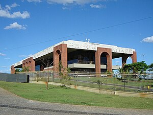
Araguaia Palace
Distance: Approx. 1988 meters
Latitude and longitude: -10.18463169,-48.33373639
The Araguaia Palace is the seat of government of the Brazilian state of Tocantins. It is located in the city of Palmas, the state capital and its largest city. It was inaugurated on March 9, 1991.

Sunflower Square
Distance: Approx. 1981 meters
Latitude and longitude: -10.18458333,-48.33369444
The Sunflower Square (Portuguese: Praça dos Girassóis) is the main public square in the Brazilian city of Palmas, the capital of the state of Tocantins. It was inaugurated in 1991 and holds the Araguaia Palace, the seat of the Tocantins government. It is also one of the largest squares in the world.
Weather in this IP's area
clear sky
37 Celsius
35 Celsius
37 Celsius
37 Celsius
1009 hPa
22 %
1009 hPa
979 hPa
10000 meters
2.06 m/s
260 degree
06:06:28
18:09:45