Country:
 Brazil
Region:
City:
Latitude and Longitude:
Time Zone:
Postal Code:
IP information under different IP Channel
ip-api
Country
Region
City
ASN
Time Zone
ISP
Blacklist
Proxy
Latitude
Longitude
Postal
Route
IPinfo
Country
Region
City
ASN
Time Zone
ISP
Blacklist
Proxy
Latitude
Longitude
Postal
Route
MaxMind
Country
Region
City
ASN
Time Zone
ISP
Blacklist
Proxy
Latitude
Longitude
Postal
Route
Luminati
Country
BRRegion
am
City
manaus
ASN
Time Zone
America/Manaus
ISP
TELEFONICA BRASIL S.A
Latitude
Longitude
Postal
db-ip
Country
Region
City
ASN
Time Zone
ISP
Blacklist
Proxy
Latitude
Longitude
Postal
Route
ipdata
Country
Region
City
ASN
Time Zone
ISP
Blacklist
Proxy
Latitude
Longitude
Postal
Route
Popular places and events near this IP address

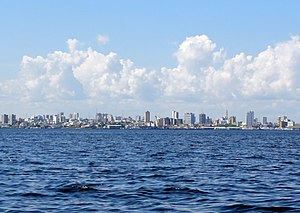
Manaus
Capital and largest city of Amazonas, Brazil
Distance: Approx. 1918 meters
Latitude and longitude: -3.11888889,-60.02166667
Manaus (Portuguese: [mɐˈnaws, ma-] ) is the capital and largest city of the Brazilian state of Amazonas. It is the seventh-largest city in Brazil, with an estimated 2022 population of 2,063,689 distributed over a land area of about 11,401 km2 (4,402 sq mi). Located at the east centre of the state, the city is the centre of the Manaus metropolitan area and the largest metropolitan area in the North Region of Brazil by urban landmass.

Vivaldão
Distance: Approx. 2244 meters
Latitude and longitude: -3.08305556,-60.02805556
Estádio Vivaldo Lima, usually known by its nickname Vivaldão, was a multi-purpose stadium in Manaus, Brazil. It was formerly used mostly for football matches. The stadium held 36,000, with 31,000 seats.
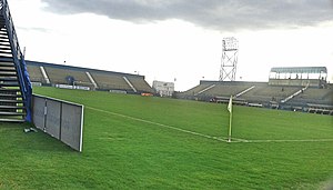
Estádio Ismael Benigno
Distance: Approx. 2313 meters
Latitude and longitude: -3.12194444,-60.03777778
Estádio Ismael Benigno, also known as Estádio da Colina, is a multi-use stadium in Manaus, Brazil. It is currently used mostly for football matches. The stadium has a capacity of 10,400 people.

Roman Catholic Archdiocese of Manaus
Catholic ecclesiastical territory
Distance: Approx. 2016 meters
Latitude and longitude: -3.11666667,-60.01666667
The Archdiocese of Manaus (Latin: Archidioecesis Manaënsis) is an archdiocese located in the city of Manaus in Brazil.
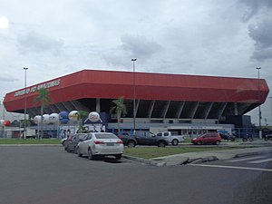
Amadeu Teixeira Arena
Indoor sporting arena in Manaus, Brazil
Distance: Approx. 2470 meters
Latitude and longitude: -3.081043,-60.027602
Arena Poliesportiva Amadeu Teixeira is an indoor sporting arena used mostly for futsal and volleyball located in Manaus, Brazil. The capacity of the arena is 11,800 spectators and opened in 2006. The venue is used for numerous events, like basketball, concerts, futsal, handball, volleyball and fight sports.
Legislative Assembly of Amazonas
State Legislature of Amazonas, Brazil
Distance: Approx. 2310 meters
Latitude and longitude: -3.08361111,-60.02194444
The Legislative Assembly of Amazonas (Portuguese: Assembleia Legislativa do Estado do Amazonas or ALEAM) is the state legislature of Amazonas. The parliament was founded in 1852 as the Provincial Legislature of the province of Amazonas. It has been installed in four different buildings, the current headquarters was opened on July 28, 2006.
Greater Manaus
Place in Amazonas, Brazil
Distance: Approx. 1395 meters
Latitude and longitude: -3.1,-60.01666667
Greater Manaus (Grande Manaus, officially Região Metropolitana de Manaus, in Portuguese) is a large metropolitan area located in Amazonas state in Brazil. It consists of 13 municipalities, including the capital, Manaus.

Arena da Amazônia
Football stadium in Amazonas, Brazil
Distance: Approx. 2244 meters
Latitude and longitude: -3.08305556,-60.02805556
Arena da Amazônia (Amazon Arena) is a football stadium in Manaus, Amazonas, Brazil, located on the former site of the Vivaldão stadium. The stadium has an all-seater capacity of 42,924 and was constructed from 2010 to 2014 as part of Brazil's hosting of the 2014 FIFA World Cup. It hosted matches of the football tournament at the 2016 Summer Olympics.
Compensa
Neighborhood in Manaus, Amazonas, Brazil
Distance: Approx. 2383 meters
Latitude and longitude: -3.1,-60.05
Compensa is a neighborhood in the western part of Manaus, Amazonas, Brazil. It is the largest district in the western section of the city and one of the largest neighborhoods in terms of population.
Manaus Monorail
Distance: Approx. 2694 meters
Latitude and longitude: -3.126,-60.02066667
Manaus Monorail (Portuguese: Monotrilho de Manaus) is a 20 kilometres (12 mi) straddle monorail unfinished for construction in the Brazilian city of Manaus. In February 2012, the Infrastructure Secretariat of Amazonas signed a contract with a consortium of CR Almedia, Mendes Junior, Serveng and Malaysian rail company Scomi Rail for the construction of the monorail. As of 2018, construction has yet to begin.

Adrianópolis, Manaus
Neighbourhood in Amazonas, North, Brazil
Distance: Approx. 2091 meters
Latitude and longitude: -3.1016961,-60.01004879
Adrianopólis is an upper class neighborhood in the South-Central Zone of Manaus, Amazonas. The neighborhood's Human Development Index (HDI) is very high, and is the largest of the city's neighborhoods and similar to that of Norway. Its old name was Vila Municipal (Town Village), by its origins related to small villages.

Chapada (Manaus)
Neighbourhood in Amazonas, North, Brazil
Distance: Approx. 1778 meters
Latitude and longitude: -3.0942406,-60.0420449
Chapada is an upper middle class neighborhood in the South-Central Zone of Manaus, Amazonas.
Weather in this IP's area
few clouds
35 Celsius
38 Celsius
35 Celsius
36 Celsius
1005 hPa
41 %
1005 hPa
1002 hPa
10000 meters
4.12 m/s
90 degree
20 %
05:52:06
17:57:43