Country:
 Brazil
Region:
City:
Latitude and Longitude:
Time Zone:
Postal Code:
IP information under different IP Channel
ip-api
Country
Region
City
ASN
Time Zone
ISP
Blacklist
Proxy
Latitude
Longitude
Postal
Route
IPinfo
Country
Region
City
ASN
Time Zone
ISP
Blacklist
Proxy
Latitude
Longitude
Postal
Route
MaxMind
Country
Region
City
ASN
Time Zone
ISP
Blacklist
Proxy
Latitude
Longitude
Postal
Route
Luminati
Country
BRRegion
es
City
vilavelha
ASN
Time Zone
America/Sao_Paulo
ISP
TELEFONICA BRASIL S.A
Latitude
Longitude
Postal
db-ip
Country
Region
City
ASN
Time Zone
ISP
Blacklist
Proxy
Latitude
Longitude
Postal
Route
ipdata
Country
Region
City
ASN
Time Zone
ISP
Blacklist
Proxy
Latitude
Longitude
Postal
Route
Popular places and events near this IP address

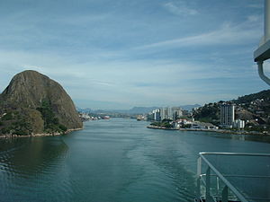
Vila Velha
Municipality in Southeast, Brazil
Distance: Approx. 6412 meters
Latitude and longitude: -20.33638889,-40.29361111
Vila Velha (Portuguese pronunciation: [ˈvilɐ ˈvɛʎɐ]; lit. 'Old Village') is a Brazilian municipality located in the state of Espírito Santo. It lies across from Vitória, the state capital. Its population was 467,722 (2022) and its area is 210.23 km2.

Viana, Espírito Santo
Municipality in Central Espírito-Santense, Brazil
Distance: Approx. 4346 meters
Latitude and longitude: -20.39,-40.3625
Viana is a municipality in the state of Espírito Santo, Brazil. It is located 18 km southwest of Vitória on the road to Minas Gerais. Its population was 79,500 (2020) and its area is 312 km2.

Penha Convent
Distance: Approx. 7426 meters
Latitude and longitude: -20.3293,-40.2871
Penha Convent (Portuguese: Convento da Penha) is a convent in Vila Velha, Brazil, on the top of a high mountain overlooking the cities of Vitória and Vila Velha. Founded in approximately 1558 by Pedro Palácios, today it is home to Espírito Santo's Patron Saint, Our Mother of Penha. Many believers make pilgrimages to this site which is surrounded by a green haven of forest.

Garoto
Brazilian chocolate manufacturer
Distance: Approx. 5742 meters
Latitude and longitude: -20.33777778,-40.30833333
Chocolates Garoto S.A. is a Brazilian chocolate manufacturer. Its headquarters are located in Vila Velha, Espírito Santo. The company was founded in 1929 by German immigrant Heinrich Meyerfreund and acquired by Nestlé in 2002.

Jucu River
River in Brazil
Distance: Approx. 3903 meters
Latitude and longitude: -20.42305556,-40.32166667
The Jucu River is a river of Espírito Santo state in eastern Brazil. The estuary of the river is in the Jacarenema Ecological Reserve, a 307 hectares (760 acres) conservation area in the city of Vila Velha. The mangroves of the estuary have suffered from pollution from waste water and garbage washed down from further up the river.

Estádio Engenheiro Alencar Araripe
Sports stadium in Brazil
Distance: Approx. 6988 meters
Latitude and longitude: -20.33444444,-40.35583333
Estádio Engenheiro Alencar Araripe or Arena Unimed Sicoob (for sponsorship reasons) is a stadium in Cariacica, Espírito Santo, Brazil. It has a capacity of 7,700 spectators. It is the home of Desportiva Ferroviária.

Jacarenema Ecological Reserve
Distance: Approx. 2959 meters
Latitude and longitude: -20.414508,-40.323044
Jacarenema Ecological Reserve (Portuguese: Reserva Ecológica de Jacarenema) is an ecological reserve in the state of Espírito Santo, Brazil. It is near the city of Vila Velha, is readily accessible to the public and does not conform to standard Brazilian definitions of environmental units.
Morro do Penedo Natural Monument
Distance: Approx. 7159 meters
Latitude and longitude: -20.323804,-40.324934
The Morro do Penedo Natural Monument (Portuguese: Monumento Natural Municipal Morro do Penedo) is a municipal natural monument in the state of Espírito Santo, Brazil. It contains a small sugarloaf hill on the shore of the bay to the south of Vitória, the state capital.

Anchieta Palace (Espírito Santo)
Palace and seat of government
Distance: Approx. 7682 meters
Latitude and longitude: -20.32127,-40.33964
The Anchieta Palace is the seat of the executive branch of the state of Espírito Santo, Brazil. It is located in the city of Vitória, directly in front of the Port of Vitória at the entrance of Cidade Alta, one of the oldest neighborhoods in the city. The palace has been used as the seat of the government of the State of Espírito Santo since the 18th century, making it one of the oldest seats of government in Brazil.
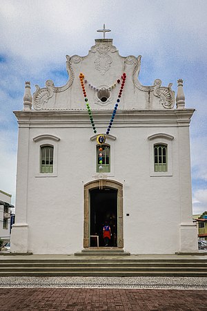
Church of Our Lady of the Rosary (Vila Velha)
Catholic temple in Vila Velha, Espírito Santo, Brazil
Distance: Approx. 7052 meters
Latitude and longitude: -20.33068889,-40.29211111
The Church of Our Lady of the Rosary (Portuguese: Igreja de Nossa Senhora do Rosário) is a Catholic temple located in the Prainha Historic Site, in the municipality of Vila Velha, in the state of Espírito Santo. It is considered one of the oldest churches in Brazil and a landmark of the colonization of the territory of Espírito Santo.
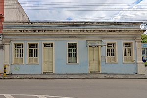
Memory House Museum
Museum in Vila Velha, Brazil
Distance: Approx. 7175 meters
Latitude and longitude: -20.329431,-40.292211
The Memory House Museum (Portuguese: Museu Casa da Memória) is a Brazilian museum in Vila Velha, created in 1997. It is located in a house built in 1893, which was restored by the DEC/ES through the efforts of a group of volunteers and Vila Velha residents. The project began in 1993 and was inaugurated as the Memory House Museum in 1994.

Academia Espírito-santense de Letras
Literary society in Brazil
Distance: Approx. 7715 meters
Latitude and longitude: -20.32092,-40.33948
The Academia Espírito-santense de Letras (Portuguese for "Espírito Santo Literary Academy", acronym AEL) is a Brazilian literary society headquartered in Vitória, Espírito Santo.
Weather in this IP's area
clear sky
26 Celsius
26 Celsius
26 Celsius
26 Celsius
1016 hPa
81 %
1016 hPa
1016 hPa
10000 meters
9.26 m/s
50 degree
05:36:10
17:36:01