Country:
 Brazil
Region:
City:
Latitude and Longitude:
Time Zone:
Postal Code:
IP information under different IP Channel
ip-api
Country
Region
City
ASN
Time Zone
ISP
Blacklist
Proxy
Latitude
Longitude
Postal
Route
IPinfo
Country
Region
City
ASN
Time Zone
ISP
Blacklist
Proxy
Latitude
Longitude
Postal
Route
MaxMind
Country
Region
City
ASN
Time Zone
ISP
Blacklist
Proxy
Latitude
Longitude
Postal
Route
Luminati
Country
BRRegion
sp
City
saovicente
ASN
Time Zone
America/Sao_Paulo
ISP
TELEFONICA BRASIL S.A
Latitude
Longitude
Postal
db-ip
Country
Region
City
ASN
Time Zone
ISP
Blacklist
Proxy
Latitude
Longitude
Postal
Route
ipdata
Country
Region
City
ASN
Time Zone
ISP
Blacklist
Proxy
Latitude
Longitude
Postal
Route
Popular places and events near this IP address
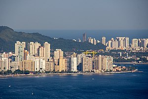
São Vicente, São Paulo
Municipality in São Paulo, Brazil
Distance: Approx. 258 meters
Latitude and longitude: -23.96333333,-46.39222222
São Vicente (after Saint Vincent of Saragossa, the patron Saint of Lisbon, Portugal) is a coastal municipality in southern São Paulo, Brazil. It is part of the Metropolitan Region of Baixada Santista. The population is 329,911 (2022 est.) in an area of 148,151 square kilometres (57,201.42 square miles).
Captaincy of São Vicente
1534–1709 captaincy in southern Brazil
Distance: Approx. 1480 meters
Latitude and longitude: -23.95,-46.38333333
The Captaincy of São Vicente (1534–1709) was a land grant and colonial administration in the far southern part of the colonial Portuguese Empire in Colonial Brazil.

Praia Grande
Municipality in São Paulo, Brazil
Distance: Approx. 5130 meters
Latitude and longitude: -24.00611111,-46.40277778
Praia Grande (Portuguese pronunciation: [ˌpɾajjaˈɡɾɐ̃dʒi]) is a municipality in the state of São Paulo in Brazil. It is part of the Metropolitan Region of Baixada Santista. The population is 330,845 (2020 est.) in an area of 149.25 km².

Estádio Urbano Caldeira
Football stadium in Brazil
Distance: Approx. 5421 meters
Latitude and longitude: -23.95111111,-46.33888889
Estádio Urbano Caldeira, also known as Vila Belmiro, is an association football stadium located in the Vila Belmiro neighborhood of Santos, São Paulo, and the home of Santos Futebol Clube. The stadium was inaugurated on 12 October 1916, when Santos FC beat Clube Atlético Ypiranga 2–1, with Adolpho Millon Jr. scoring the first goal of the stadium.

Estádio Ulrico Mursa
Distance: Approx. 5681 meters
Latitude and longitude: -23.94711111,-46.33736111
Estádio Ulrico Mursa is a football (soccer) stadium located in Santos, São Paulo state, Brazil. The stadium was built in 1920 and is able to hold approximately 7,600 people. The stadium is owned by Associação Atlética Portuguesa and its formal name honors Ulrico Mursa, who was Companhia Docas de Santos director.

Baixada Santista
Metropolitan area in São Paulo state
Distance: Approx. 5810 meters
Latitude and longitude: -23.96083333,-46.33388889
The Região Metropolitana da Baixada Santista is a metropolitan area located on the coast of São Paulo state in Brazil, with a population of 1.7 million. Its most populous city is Santos. As an administrative division (Região Metropolitana da Baixada Santista), it was created on 30 July 1996.
All Saints' Church, Santos
Distance: Approx. 4366 meters
Latitude and longitude: -23.96555556,-46.34833333
All Saints' Church is a Christian church of Anglican tradition, in the port city of Santos, in the state of São Paulo, Brazil, in April 1918. It was established as a chaplaincy of the Church of England, where its main function was to assist both the resident Anglican community and sailors of all nationalities who passed through the port. Currently, it's the only established church at Baixada Santista Metropolitan Region that is associated to Anglican Communion and is part of Anglican Diocese of The São Paulo, of Episcopal Anglican Church of the Brazil.

São Vicente Island (São Paulo, Brazil)
Island in Brazil
Distance: Approx. 3395 meters
Latitude and longitude: -23.95,-46.36
São Vicente Island (São Paulo, Brazil) (Ilha de São Vicente) is an island in São Paulo state, Brazil. It has an area of 57.4 km2 and a population of 760,000 people. The population density is 13,240/ km2, making it the most densely populated island in Brazil, and the 38th most densely populated island in the world.
Arena Santos
Sporting venue in Brazil
Distance: Approx. 6247 meters
Latitude and longitude: -23.94216667,-46.33327778
Arena Santos is an indoor sporting arena located in Santos in São Paulo, Brazil, used for table tennis. The seating capacity of the arena is 5,000 people, and it was opened on 27 October 2010. Arena Santos was the location for some of the matches of the 2011 World Women's Handball Championship.
Xixová-Japuí State Park
State park in São Paulo, Brazil
Distance: Approx. 4988 meters
Latitude and longitude: -24.006111,-46.391389
The Xixová-Japuí State Park (Portuguese: Parque Estadual Xixová-Japuí) is a State park in the state of São Paulo, Brazil. It protects an isolated area of well-preserved Atlantic Forest on the Atlantic coast near the city of São Paulo.

São Vicente Suspension Bridge
Bridge in São Vicente
Distance: Approx. 1595 meters
Latitude and longitude: -23.97548889,-46.38884694
São Vicente Suspension Bridge (Portuguese: Ponte Pênsil de São Vicente) is a suspension bridge in São Vicente, São Paulo, Brazil. It was one of the first suspension bridges in Brazil, and carries vehicle and pedestrian traffic between Morro dos Barbosas and Japuí. Originally conceived in 1910 as a way to carry sewage away from the city of Santos and São Vicente, construction started in 1911, and the bridge opened in May 1914.

Memorial Necrópole Ecumênica
Vertical cemetery in Brazil
Distance: Approx. 5037 meters
Latitude and longitude: -23.94836,-46.34355
The Memorial Necrópole Ecumênica is a Brazilian cemetery. Located in Santos, in the state of São Paulo, its construction began in 1983, and the first burial was on 28 July 1984. It was formally inaugurated on 20 September 1991.
Weather in this IP's area
light intensity drizzle
17 Celsius
17 Celsius
17 Celsius
20 Celsius
1022 hPa
70 %
1022 hPa
1021 hPa
1000 meters
2.24 m/s
2.24 m/s
40 degree
100 %
06:01:03
17:59:42