Country:
 Brazil
Region:
City:
Latitude and Longitude:
Time Zone:
Postal Code:
IP information under different IP Channel
ip-api
Country
Region
City
ASN
Time Zone
ISP
Blacklist
Proxy
Latitude
Longitude
Postal
Route
IPinfo
Country
Region
City
ASN
Time Zone
ISP
Blacklist
Proxy
Latitude
Longitude
Postal
Route
MaxMind
Country
Region
City
ASN
Time Zone
ISP
Blacklist
Proxy
Latitude
Longitude
Postal
Route
Luminati
Country
BRRegion
se
City
umbauba
ASN
Time Zone
America/Maceio
ISP
ALOO TELECOM - FSF TECNOLOGIA SA
Latitude
Longitude
Postal
db-ip
Country
Region
City
ASN
Time Zone
ISP
Blacklist
Proxy
Latitude
Longitude
Postal
Route
ipdata
Country
Region
City
ASN
Time Zone
ISP
Blacklist
Proxy
Latitude
Longitude
Postal
Route
Popular places and events near this IP address

Maceió
Capital city of Alagoas, Brazil
Distance: Approx. 3371 meters
Latitude and longitude: -9.66583333,-35.735
Maceió (Portuguese pronunciation: [masejˈjɔ]), formerly sometimes Anglicised as Maceio, is the capital and the largest city of the coastal state of Alagoas, Brazil. The name "Maceió" is an Indigenous term for a spring. Most maceiós flow to the sea, but some get trapped and form lakes ("lagoas", in Portuguese).

Mundaú Lagoon
Estuarine lagoon in Coqueiro Seco, Alagoas
Distance: Approx. 8331 meters
Latitude and longitude: -9.633,-35.783
Mundaú Lagoon is an estuarine lagoon situated west of Maceió, capital city of Alagoas state, in Brazil. Its total area is 24 km2 (9.3 sq mi). The lake receives the Mundaú River, and is connected to the Atlantic Ocean and Manguaba Lagoon by a network of canals which cross the plain forming a lot of little islands.
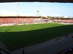
Estádio Rei Pelé
Multi-purpose stadium in Maceió, Brazil
Distance: Approx. 5975 meters
Latitude and longitude: -9.67055556,-35.75916667
The Estádio Rei Pelé, also known as Trapichão, is a multi-purpose stadium in Maceió, Brazil. It is currently used mostly for football matches. The stadium holds 19,105.
Estádio Severiano Gomes Filho
Brazilian association football venue
Distance: Approx. 1894 meters
Latitude and longitude: -9.6639,-35.7185
Estádio Severiano Gomes Filho, also known as Estádio Pajuçara, was a multi-use stadium in Pajuçara neighborhood, Maceió, Brazil. It was used mostly for football matches. The stadium had a capacity of 6,000 people.
Estádio Mutange
Multi-use Stadium
Distance: Approx. 4627 meters
Latitude and longitude: -9.64,-35.75
Estádio Mutange, also known as Estádio Gustavo Paiva, is a multi-use stadium located in Maceió, Brazil. It is used mostly for football matches and hosts the home matches of Centro Sportivo Alagoano and Associação Atlética Ponte Preta (AL), and hosted the home matches of Esporte Clube Barroso. The stadium has a maximum capacity of 4,000 people and was built in 1922.

Roman Catholic Archdiocese of Maceió
Catholic ecclesiastical territory
Distance: Approx. 3353 meters
Latitude and longitude: -9.6652,-35.7352
The Roman Catholic Archdiocese of Maceió (Latin: Archidioecesis Maceiensis) is an archdiocese located in the city of Maceió in Brazil.
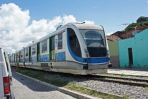
Maceió Urban Rail
Distance: Approx. 3371 meters
Latitude and longitude: -9.66583333,-35.735
Maceió Urban Rail (Portuguese: Sistema de Trens Urbanos de Maceió) is the 32.1-kilometre (19.9 mi) metre gauge diesel commuter rail line that serves the city of Maceió, Alagoas, Brazil. The line connects Maceió with two cities in the metropolitan area, Satuba and Rio Largo (the line's northern terminus).

Historic and Geographic Institute of Alagoas
Brazilian organization
Distance: Approx. 3404 meters
Latitude and longitude: -9.662,-35.7374
The Historic and Geographic Institute of Alagoas - IHGAL (Portuguese: Instituto Histórico e Geográfico de Alagoas) is a civil organization dedicated to the study and research in several fields of history, geography, and social sciences. It is located in downtown Maceió, in a building listed as a state heritage site. It was founded on December 2, 1869, and is the third oldest institution of its kind in Brazil.

Province of Alagoas
Former territorial division in Brazil
Distance: Approx. 2671 meters
Latitude and longitude: -9.65,-35.73333333
The Province of Alagoas was part of the United Kingdom of Portugal, Brazil and the Algarves, and later of the Empire of Brazil, being created after the Captaincy of Alagoas.
TV Gazeta de Alagoas
Television station in Alagoas, Brazil
Distance: Approx. 2847 meters
Latitude and longitude: -9.66171667,-35.7319
TV Gazeta de Alagoas (channel 7, also known as TV Gazeta) is a Brazilian television station based in Maceió, capital of the state of Alagoas, carrying TV Globo for the state, owned-and-operated by locally based Organização Arnon de Mello, a communications group linked to the former President of the Republic Fernando Collor de Mello.
Weather in this IP's area
few clouds
23 Celsius
23 Celsius
23 Celsius
23 Celsius
1018 hPa
88 %
1018 hPa
1017 hPa
10000 meters
2.06 m/s
100 degree
20 %
05:15:57
17:19:22