Country:
 Brazil
Region:
City:
Latitude and Longitude:
Time Zone:
Postal Code:
IP information under different IP Channel
ip-api
Country
Region
City
ASN
Time Zone
ISP
Blacklist
Proxy
Latitude
Longitude
Postal
Route
IPinfo
Country
Region
City
ASN
Time Zone
ISP
Blacklist
Proxy
Latitude
Longitude
Postal
Route
MaxMind
Country
Region
City
ASN
Time Zone
ISP
Blacklist
Proxy
Latitude
Longitude
Postal
Route
Luminati
Country
BRRegion
se
City
aracaju
ASN
Time Zone
America/Maceio
ISP
ALOO TELECOM - FSF TECNOLOGIA SA
Latitude
Longitude
Postal
db-ip
Country
Region
City
ASN
Time Zone
ISP
Blacklist
Proxy
Latitude
Longitude
Postal
Route
ipdata
Country
Region
City
ASN
Time Zone
ISP
Blacklist
Proxy
Latitude
Longitude
Postal
Route
Popular places and events near this IP address

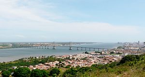
Aracaju
Capital city of Sergipe, Brazil
Distance: Approx. 9363 meters
Latitude and longitude: -10.9167,-37.05
Aracaju (Portuguese pronunciation: [aɾakaˈʒu]) is the capital of the state of Sergipe, Brazil, located in the northeastern part of the country on the coast, about 350 km (217 mi) north of Salvador. According to the 2020 estimate, the city has 664,908 inhabitants, which represents approximately 33% of the state population. Adding to the populations of the municipalities forming the Metropolitan area: Barra dos Coqueiros, Nossa Senhora do Socorro and São Cristóvão.
Estádio João Hora de Oliveira
Distance: Approx. 7164 meters
Latitude and longitude: -10.92333333,-37.07222222
Estádio João Hora de Oliveira is a multi-use stadium located in Aracaju, Brazil. It is used mostly for football matches and hosts the home matches of Club Sportivo Sergipe. The stadium has a maximum capacity of 10,000 people.

Batistão
Distance: Approx. 8721 meters
Latitude and longitude: -10.92666667,-37.04916667
Estádio Lourival Baptista, commonly known as Batistão, is a multi-use stadium located in Aracaju, Brazil. It is used mostly for football matches and hosts the home matches of Associação Desportiva Confiança, Cotinguiba, Club Sportivo Sergipe and Vasco Esporte Clube. The stadium has a maximum capacity of 15,575 people, and was built in 1969.

Santa Maria Airport (Sergipe)
Brazilian airport
Distance: Approx. 4509 meters
Latitude and longitude: -10.98527778,-37.07333333
Aracaju–Santa Maria International Airport (IATA: AJU, ICAO: SBAR) is the airport serving Aracaju, Brazil.

Roman Catholic Archdiocese of Aracaju
Catholic ecclesiastical territory
Distance: Approx. 9492 meters
Latitude and longitude: -10.9133,-37.0517
The Roman Catholic Metropolitan Archdiocese of Aracaju (Latin: Archidioecesis Metropolitae Aracaiuensis) is a Latin Metropolitan archdiocese in the State of Sergipe, northeastern Brazil. Its cathedral archiepiscopal see is Our Lady of the Conception Cathedral (Catedral Metropolitana Nossa Senhora da Conceiçao), dedicated to Our Lady of Immaculate Conception, in the city of Aracaju. Two World Heritage Sites are owned by the Archdiocese in São Cristóvão, Sergipe: the Misericórdia Hospital and Church (Igreja de Santa Casa de Misericórdia) and the Church and Convent of Santa Cruz, also known as the Church and Convent of Saint Francis.
Sergipe River
River in Brazil
Distance: Approx. 8810 meters
Latitude and longitude: -10.96111111,-37.03333333
The Sergipe River (Portuguese: Rio Sergipe) is a river of Sergipe state in northeastern Brazil.
Federal University of Sergipe
Public university in the state of Sergipe, Brazil
Distance: Approx. 5618 meters
Latitude and longitude: -10.9248113,-37.1005511
The Federal University of Sergipe (Portuguese: Universidade Federal de Sergipe, UFS) is a Brazilian public institution based in Sergipe, with campuses in São Cristóvão, Aracaju, Itabaiana, Laranjeiras, and Lagarto. Founded in 1967 by the junction of the state's existing colleges, it became its second university (the first being the University of Tiradentes, a private institution founded in 1962) and its first public one. It became the state's most reputable and disputed higher education institution, ranking among the country's 40 best universities and Latin America's top 200 list.

Legislative Assembly of Sergipe
Distance: Approx. 9732 meters
Latitude and longitude: -10.91388889,-37.04805556
The Legislative Assembly of Sergipe (Portuguese: Assembleia Legislativa de Sergipe) is the unicameral legislature of Sergipe state in Brazil. It has 24 state deputies elected by proportional representation. The Province of Sergipe was consolidated on October 24, 1824.

Our Lady of the Conception Cathedral, Aracaju
Church in Aracaju, Brazil
Distance: Approx. 9554 meters
Latitude and longitude: -10.9131,-37.0511
The Our Lady of the Conception Cathedral (Portuguese: Catedral Metropolitana Nossa Senhora da Conceiçao), also known as the Metropolitan Cathedral of Aracaju and commonly as the Aracaju Cathedral, is a Roman Catholic church in Aracaju, Sergipe, Brazil. It is dedicated to Our Lady of Conception. Construction on the church began in 1862 under Father Eliziário Vieira Moniz Teles.
Aeroclube de Sergipe
Airport
Distance: Approx. 8696 meters
Latitude and longitude: -10.90138889,-37.08305556
Aeroclube de Sergipe (ICAO: SISG) is a private aerodrome located in Aracaju, Brazil.
Weather in this IP's area
clear sky
25 Celsius
25 Celsius
25 Celsius
25 Celsius
1018 hPa
73 %
1018 hPa
1015 hPa
10000 meters
4.12 m/s
100 degree
05:21:46
17:24:46