176.97.255.84 - IP Lookup: Free IP Address Lookup, Postal Code Lookup, IP Location Lookup, IP ASN, Public IP
Country:
 Poland
Region:
City:
Location:
Time Zone:
Postal Code:
ISP:
ASN:
language:
User-Agent:
Proxy IP:
Blacklist:
IP information under different IP Channel
ip-api
Country
Region
City
ASN
Time Zone
ISP
Blacklist
Proxy
Latitude
Longitude
Postal
Route
db-ip
Country
Region
City
ASN
Time Zone
ISP
Blacklist
Proxy
Latitude
Longitude
Postal
Route
IPinfo
Country
Region
City
ASN
Time Zone
ISP
Blacklist
Proxy
Latitude
Longitude
Postal
Route
IP2Location
176.97.255.84Country
plRegion
warminsko-mazurskie
City
dobre miasto
Time Zone
Europe/Warsaw
ISP
Language
User-Agent
Latitude
Longitude
Postal
ipdata
Country
Region
City
ASN
Time Zone
ISP
Blacklist
Proxy
Latitude
Longitude
Postal
Route
Popular places and events near this IP address
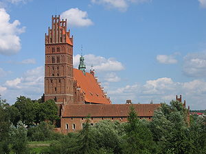
Dobre Miasto
Place in Warmian-Masurian Voivodeship, Poland
Distance: Approx. 141 meters
Latitude and longitude: 53.9875,20.39583333
Dobre Miasto (Polish: [ˈdɔbrɛ ˈmjastɔ]; German: Guttstadt [ˈɡʊt.ʃtat] ; literally Good City) is a town in Poland, in the Warmian-Masurian Voivodeship with 9,857 inhabitants as of December 2021. It is situated in the northwestern part of the Masurian Lake District in the heart of the historical region of Warmia. It is also the seat of Dobre Miasto Commune which consists of the main town and 21 village administrative divisions, with a total population of 16,014.

Gmina Dobre Miasto
Gmina in Warmian-Masurian Voivodeship, Poland
Distance: Approx. 141 meters
Latitude and longitude: 53.9875,20.39583333
Gmina Dobre Miasto is an urban-rural gmina (administrative district) in Olsztyn County, Warmian-Masurian Voivodeship, in northern Poland. Its seat is the town of Dobre Miasto, which lies approximately 24 kilometres (15 mi) north of the regional capital Olsztyn. The gmina covers an area of 258.7 square kilometres (99.9 sq mi), and as of 2006 its total population is 15,920 (out of which the population of Dobre Miasto amounts to 10,489, and the population of the rural part of the gmina is 5,431).

Smolajny
Village in Warmian-Masurian Voivodeship, Poland
Distance: Approx. 4671 meters
Latitude and longitude: 54.02833333,20.40638889
Smolajny [smɔˈlai̯nɨ] (formerly Smołowo) is a village in the administrative district of Gmina Dobre Miasto, within Olsztyn County, Warmian-Masurian Voivodeship, in northern Poland. It lies on the Łyna River in the historical region of Warmia, approximately 5 kilometres (3 mi) north of Dobre Miasto and 28 km (17 mi) north of the regional capital Olsztyn.
Barcikowo, Warmian-Masurian Voivodeship
Village in Warmian-Masurian Voivodeship, Poland
Distance: Approx. 5339 meters
Latitude and longitude: 53.95,20.45
Barcikowo [bart͡ɕiˈkɔvɔ] is a village in the administrative district of Gmina Dobre Miasto, within Olsztyn County, Warmian-Masurian Voivodeship, in northern Poland. It lies approximately 6 kilometres (4 mi) south-east of Dobre Miasto and 19 km (12 mi) north of the regional capital Olsztyn. Before 1772 the area was part of Kingdom of Poland, and in 1772–1945 it belonged to Prussia and Germany (East Prussia).
Głotowo
Village in Warmian-Masurian Voivodeship, Poland
Distance: Approx. 5135 meters
Latitude and longitude: 53.95,20.35
Głotowo [ɡwɔˈtɔvɔ] is a village in the administrative district of Gmina Dobre Miasto, within Olsztyn County, Warmian-Masurian Voivodeship, in northern Poland. It lies approximately 6 kilometres (4 mi) south-west of Dobre Miasto and 21 km (13 mi) north-west of the regional capital Olsztyn. When the area was Christianised through the Northern Crusades, Głotowo developed into an important Christian pilgrimage site.
Knopin
Village in Warmian-Masurian Voivodeship, Poland
Distance: Approx. 3235 meters
Latitude and longitude: 53.95805556,20.40583333
Knopin [ˈknɔpin] is a village in the administrative district of Gmina Dobre Miasto, within Olsztyn County, Warmian-Masurian Voivodeship, in northern Poland. It lies approximately 4 kilometres (2 mi) south of Dobre Miasto and 21 km (13 mi) north of the regional capital Olsztyn.
Kosyń, Warmian-Masurian Voivodeship
Village in Warmian-Masurian Voivodeship, Poland
Distance: Approx. 1847 meters
Latitude and longitude: 54.00277778,20.40444444
Kosyń [ˈkɔsɨɲ] is a village in the administrative district of Gmina Dobre Miasto, within Olsztyn County, Warmian-Masurian Voivodeship, in northern Poland.
Nowa Wieś Mała, Olsztyn County
Village in Warmian-Masurian Voivodeship, Poland
Distance: Approx. 3188 meters
Latitude and longitude: 53.99027778,20.34916667
Nowa Wieś Mała [ˈnɔva ˈvjɛɕ ˈmawa] is a village in the administrative district of Gmina Dobre Miasto, within Olsztyn County, Warmian-Masurian Voivodeship, in northern Poland.
Stary Dwór, Gmina Dobre Miasto
Village in Warmian-Masurian Voivodeship, Poland
Distance: Approx. 3875 meters
Latitude and longitude: 53.9575,20.42972222
Stary Dwór [ˈstarɨ ˈdvur] is a village in the administrative district of Gmina Dobre Miasto, within Olsztyn County, Warmian-Masurian Voivodeship, in northern Poland.
Swobodna
Village in Warmian-Masurian Voivodeship, Poland
Distance: Approx. 4089 meters
Latitude and longitude: 53.95,20.4
Swobodna [sfɔˈbɔdna] is a village in the administrative district of Gmina Dobre Miasto, within Olsztyn County, Warmian-Masurian Voivodeship, in northern Poland. It lies approximately 5 kilometres (3 mi) south of Dobre Miasto and 20 km (12 mi) north of the regional capital Olsztyn.

Wichrowo
Village in Warmian-Masurian Voivodeship, Poland
Distance: Approx. 5010 meters
Latitude and longitude: 54.02638889,20.43361111
Wichrowo [viˈxrɔvɔ] is a village in the administrative district of Gmina Dobre Miasto, within Olsztyn County, Warmian-Masurian Voivodeship, in northern Poland.
Kunik, Poland
Village in Warmian-Masurian Voivodeship, Poland
Distance: Approx. 2624 meters
Latitude and longitude: 54.00694444,20.37694444
Kunik [ˈkunik] is a village in the administrative district of Gmina Dobre Miasto, within Olsztyn County, Warmian-Masurian Voivodeship, in northern Poland.
Weather in this IP's area
scattered clouds
2 Celsius
-0 Celsius
2 Celsius
2 Celsius
1033 hPa
72 %
1033 hPa
1020 hPa
10000 meters
2.15 m/s
4.69 m/s
276 degree
37 %