176.94.234.1 - IP Lookup: Free IP Address Lookup, Postal Code Lookup, IP Location Lookup, IP ASN, Public IP
Country:
Region:
City:
Location:
Time Zone:
Postal Code:
IP information under different IP Channel
ip-api
Country
Region
City
ASN
Time Zone
ISP
Blacklist
Proxy
Latitude
Longitude
Postal
Route
Luminati
Country
Region
by
City
stockstadtammain
ASN
Time Zone
Europe/Berlin
ISP
Vodafone GmbH
Latitude
Longitude
Postal
IPinfo
Country
Region
City
ASN
Time Zone
ISP
Blacklist
Proxy
Latitude
Longitude
Postal
Route
IP2Location
176.94.234.1Country
Region
hessen
City
gelnhausen
Time Zone
Europe/Berlin
ISP
Language
User-Agent
Latitude
Longitude
Postal
db-ip
Country
Region
City
ASN
Time Zone
ISP
Blacklist
Proxy
Latitude
Longitude
Postal
Route
ipdata
Country
Region
City
ASN
Time Zone
ISP
Blacklist
Proxy
Latitude
Longitude
Postal
Route
Popular places and events near this IP address

Gelnhausen
Town in Hesse, Germany
Distance: Approx. 1488 meters
Latitude and longitude: 50.2,9.16666667
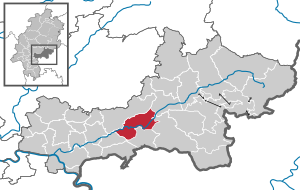
Gelnhausen (German pronunciation: [ɡɛlnˈhaʊ̯zn̩] ) is a town, and the capital of the Main-Kinzig-Kreis, in Hesse, Germany. It is located approximately 40 kilometers east of Frankfurt am Main, between the Vogelsberg mountains and the Spessart range at the river Kinzig. It is one of the eleven towns (urban municipalities) in the district.
Coleman Kaserne
US Army base in Hessen, Germany, 1933–1992
Distance: Approx. 1282 meters
Latitude and longitude: 50.20777778,9.17222222
Coleman Kaserne (original German name: Kaserne Gelnhausen) was a United States Army base located in the German city of Gelnhausen, located in the state of Hessen. Coleman Kaserne should not be confused with the U.S. Army "Coleman Barracks" which is located in Mannheim. Kaserne is a German word for barracks.

Freigericht
Municipality in Hesse, Germany
Distance: Approx. 7911 meters
Latitude and longitude: 50.14166667,9.12777778
Freigericht is a municipality in the Main-Kinzig district, in Hesse, Germany. It is situated 15 km east of Hanau, close to the Frankfurt Rhein-Main region at the foothills of the Spessart, directly at the Hesse-Bavaria border. More than 40% of the area is forested.
Biebergemünd
Municipality in Hesse, Germany
Distance: Approx. 6605 meters
Latitude and longitude: 50.20694444,9.27972222
Biebergemünd is a municipality in the Main-Kinzig district, in Hesse, Germany. It has a population of over 8,000 and lies in the wooded hills of the Spessart.

Hasselroth
Municipality in Hesse, Germany
Distance: Approx. 7344 meters
Latitude and longitude: 50.16666667,9.1
Hasselroth is a municipality in the Main-Kinzig district, in Hessen, Germany.

Linsengericht
Municipality in Hesse, Germany
Distance: Approx. 4413 meters
Latitude and longitude: 50.16666667,9.21666667
Linsengericht is a municipality in the Main-Kinzig district, in Hesse, Germany.

Gründau
Municipality in Hesse, Germany
Distance: Approx. 3148 meters
Latitude and longitude: 50.21666667,9.15
Gründau is a municipality in the district Main-Kinzig, in Hesse, Germany.
Huckelheimer Bach
River in Germany
Distance: Approx. 9172 meters
Latitude and longitude: 50.1265,9.2403
Huckelheimer Bach is a small river of Bavaria, Germany. It is the right headwater of the Westerbach in Westerngrund.
Querbach (Westerbach)
River in Germany
Distance: Approx. 9172 meters
Latitude and longitude: 50.1265,9.2403
Querbach is a river of Bavaria, Germany. It is the left headwater of the Westerbach. The Querbach rises in the Arzborn (sometimes called Atzborn), a larger spring on the Hoher Querberg (474 m).
Westerbach (Kahl)
River in Germany
Distance: Approx. 9082 meters
Latitude and longitude: 50.127549,9.240843
The Westerbach is a right tributary of the Kahl in the northern Spessart in Lower Franconia, Bavaria, Germany. It is 6.3 km (3.9 mi) long (7.2 km including Querbach) and begins at the confluence of Querbach and Huckelheimer Bach in Westerngrund. The Querbach rises in the Arzborn, a small opening in the mountainside on the Hoher Querberg, northeast of Huckelheim, near the border between Hesse and Bavaria.

Gelnhausen station
Railway station in Gelnhausen, Germany
Distance: Approx. 574 meters
Latitude and longitude: 50.196617,9.189453
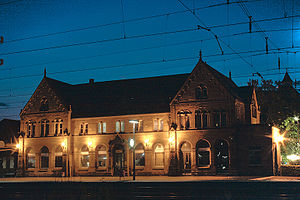
Gelnhausen station is the station of the town of Gelnhausen on the Frankfurt–Göttingen railway in the German state of Hesse.

Imperial Palace, Gelnhausen
Palace in Gelnhausen, Germany
Distance: Approx. 608 meters
Latitude and longitude: 50.2,9.19555556
The Imperial Palace at Gelnhausen (called in German Kaiserpfalz Gelnhausen, Pfalz Gelnhausen or Barbarossaburg) is located on a former island in the Kinzig river in Gelnhausen, Hesse, Germany.
Weather in this IP's area
overcast clouds
4 Celsius
1 Celsius
2 Celsius
4 Celsius
1025 hPa
89 %
1025 hPa
1008 hPa
10000 meters
2.6 m/s
7.2 m/s
279 degree
89 %


