Country:
 Germany
Region:
City:
Latitude and Longitude:
Time Zone:
Postal Code:
IP information under different IP Channel
ip-api
Country
Region
City
ASN
Time Zone
ISP
Blacklist
Proxy
Latitude
Longitude
Postal
Route
IPinfo
Country
Region
City
ASN
Time Zone
ISP
Blacklist
Proxy
Latitude
Longitude
Postal
Route
MaxMind
Country
Region
City
ASN
Time Zone
ISP
Blacklist
Proxy
Latitude
Longitude
Postal
Route
Luminati
Country
DERegion
rp
City
worms
ASN
Time Zone
Europe/Berlin
ISP
Vodafone GmbH
Latitude
Longitude
Postal
db-ip
Country
Region
City
ASN
Time Zone
ISP
Blacklist
Proxy
Latitude
Longitude
Postal
Route
ipdata
Country
Region
City
ASN
Time Zone
ISP
Blacklist
Proxy
Latitude
Longitude
Postal
Route
Popular places and events near this IP address

Düsseldorf-Oberkassel
City district of Düsseldorf, Germany
Distance: Approx. 1701 meters
Latitude and longitude: 51.23027778,6.755
Oberkassel (Limburgish: Ueverkassel) is a part of Düsseldorf's Borough 4. Oberkassel lies on the west side of the river Rhine, the opposite side of the central district of Düsseldorf. It has an area of 3.68 km2 (1.42 sq mi), and 19,052 inhabitants (2020).

Heerdt
City district of Düsseldorf, Germany
Distance: Approx. 1355 meters
Latitude and longitude: 51.22833333,6.71583333
Heerdt is one of the older quarters of the city of Düsseldorf, part of Borough 4. Heerdt and its neighbouring quarters Oberkassel, Niederkassel and Lörick lie on the left side of the river Rhine, opposite to the other districts of Düsseldorf and the central district. Heerdt has an area of 4.05 km2 (1.56 sq mi), and 12,395 inhabitants (2020).
Theodor Heuss Bridge (Düsseldorf)
Bridge over the Rhine
Distance: Approx. 2339 meters
Latitude and longitude: 51.24694444,6.75972222
The Theodor Heuss Bridge also known as the Nordbrücke (North bridge) is a cable-stayed bridge over the Rhine River in Düsseldorf built from 1953 to 1957 with a main span of 260 m (850 ft) flanked on either side by spans of 108 m (354 ft). It was the first cable-stayed bridge built in Germany. Along with two other cable-stayed bridges to the south, the Oberkassel Bridge and the Knie Bridge, the Theodor Heuss Bridge forms the central leg of Düsseldorf's family of bridges over the Rhine.

Düsseldorf-Hafen
Stadtteil of Düsseldorf in North Rhine-Westphalia, Germany
Distance: Approx. 2538 meters
Latitude and longitude: 51.21916667,6.75777778
Düsseldorf-Hafen is an urban quarter of Düsseldorf, Germany, part of Borough 3, located on the river Rhine and the location of the city's docks. The quarter covers 3.79 km2 (1.46 sq mi), and is predominantly commercial and industrial in nature, with a very small residential population. It had 110 residents in the year 2020, making it the Düsseldorf quarter with the lowest population density.
Düsseldorf-Niederkassel
Stadtteil of Düsseldorf in North Rhine-Westphalia, Germany
Distance: Approx. 1371 meters
Latitude and longitude: 51.24,6.75
Niederkassel is a quarter of the city of Düsseldorf, part of Borough 4. It is located on the west side of the river Rhine, bordering Oberkassel and Lörick. It has an area of 2.34 km2 (0.90 sq mi), and 6,079 inhabitants (2020).

Lörick
City district of Düsseldorf, Germany
Distance: Approx. 1278 meters
Latitude and longitude: 51.24638889,6.72777778
Lörick is an urban quarter of Düsseldorf, Germany, part of Borough 4. It is located on the left side of the river Rhine, bordering to the river, Niederkassel, Heerdt and Meerbusch. It has an area of 2.55 km2 (0.98 sq mi), and 7,513 inhabitants (2020).

Largest Fair on the Rhine
Distance: Approx. 2342 meters
Latitude and longitude: 51.22777778,6.76333333
The Largest Fair on the Rhine (German: Größte Kirmes am Rhein) is a fair in Düsseldorf, one of Germany's largest. It takes place the third week in July on the left bank of the Rhine River, in the district Düsseldorf-Oberkassel, and features beer and food tents, amusement park rides, and vendors.

Borough 4 (Düsseldorf)
Borough of Düsseldorf in North Rhine-Westphalia, Germany
Distance: Approx. 1683 meters
Latitude and longitude: 51.23027778,6.75472222
Borough 4 (German: Stadtbezirk 4) is a borough of Düsseldorf, the state capital of North Rhine-Westphalia, Germany. It covers an area of 12.62 square kilometres and has about 45,000 inhabitants (2020). Borough 4 is the city's only borough on the west bank of the Rhine and its quarters are popular residential areas.

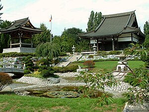
Japanische Internationale Schule in Düsseldorf
Primary & middle school in Düsseldorf, Germany
Distance: Approx. 599 meters
Latitude and longitude: 51.23665,6.74017
Japanische Internationale Schule e.V. in Düsseldorf (デュッセルドルフ日本人学校, Dyusserudorufu Nihonjin Gakkō, JISD, German: "Japanese International School in Düsseldorf") is a Japanese international school in Oberkassel, Düsseldorf, Germany. Japanische Ergänzungsschule in Düsseldorf (デュッセルドルフ日本語補習校 Dyusserudorufu Nihongo Hoshūkō), a Japanese weekend school, is a part of the institution.

Deutsche Apotheker- und Ärztebank
Distance: Approx. 1097 meters
Latitude and longitude: 51.244552,6.73686
The Deutsche Apotheker- und Ärztebank eG (ApoBank, German bank for pharmacists and physicians) is a cooperative bank headquartered in Düsseldorf. Apobank has been designated as a Significant Institution since the entry into force of European Banking Supervision in late 2014, and as a consequence is directly supervised by the European Central Bank.
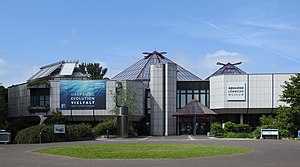
Aquazoo Löbbecke Museum
Natural history museum Zoo Aquarium in Düsseldorf, Germany
Distance: Approx. 2666 meters
Latitude and longitude: 51.2564,6.7497
The Aquazoo Löbbecke Museum unites Zoo, Natural History Museum and Aquarium in one institution under the administration of the city of Düsseldorf. It was opened in 1987 in the North Park under the name "Löbbecke-Museum + Aquazoo" (there have been precursor institutions on different locations in Düsseldorf though). On an area of about 2000 square meters, around 500 animal species are exhibited in 25 themed rooms in aquariums, terrariums and a tropical hall.

Rheinkniebrücke
Bridge
Distance: Approx. 2761 meters
Latitude and longitude: 51.22083333,6.76416667
The Rheinkniebrücke (English: Rhine knee bridge) is a cable-stayed bridge leading over the Rhine at the Rheinknie in Düsseldorf with a six-lane motor road and two combined pedestrian and cycle paths, which was opened to traffic on 16 October 1969.
Weather in this IP's area
clear sky
23 Celsius
23 Celsius
22 Celsius
25 Celsius
1021 hPa
65 %
1021 hPa
1017 hPa
10000 meters
7.2 m/s
40 degree
07:14:56
19:38:43