Country:
Region:
City:
Latitude and Longitude:
Time Zone:
Postal Code:
IP information under different IP Channel
ip-api
Country
Region
City
ASN
Time Zone
ISP
Blacklist
Proxy
Latitude
Longitude
Postal
Route
Luminati
Country
Region
he
City
kelkheim
ASN
Time Zone
Europe/Berlin
ISP
Vodafone GmbH
Latitude
Longitude
Postal
IPinfo
Country
Region
City
ASN
Time Zone
ISP
Blacklist
Proxy
Latitude
Longitude
Postal
Route
db-ip
Country
Region
City
ASN
Time Zone
ISP
Blacklist
Proxy
Latitude
Longitude
Postal
Route
ipdata
Country
Region
City
ASN
Time Zone
ISP
Blacklist
Proxy
Latitude
Longitude
Postal
Route
Popular places and events near this IP address

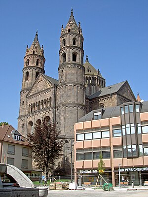
Worms Cathedral
Church in Rhineland-Palatinate, Germany
Distance: Approx. 2192 meters
Latitude and longitude: 49.63027778,8.35972222
St Peter's Cathedral (German: Wormser Dom) is a Roman Catholic church and former cathedral in Worms, southern Germany. The cathedral is located on the highest point of the inner city of Worms and is the most important building of the Romanesque style in Worms. It is closely associated with Bishop Burchard and the high point of Worms' history in the 12th and 13th centuries.

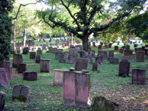
Jewish Cemetery, Worms
Historic cemetery in Germany
Distance: Approx. 1925 meters
Latitude and longitude: 49.62972222,8.35555556
The Jewish Cemetery in Worms or Heiliger Sand, in Worms, Germany, is usually called the oldest surviving Jewish cemetery in Europe, although the Jewish burials in the Jewish sections of the Roman catacombs predate it by a millennium. The Jewish community of Worms was established by the early eleventh century, and the oldest tombstone still legible dates from 1058/59. The cemetery was closed in 1911, when a new cemetery was inaugurated.
Wormatia-Stadion
Stadium in Worms, Germany
Distance: Approx. 614 meters
Latitude and longitude: 49.63138056,8.33580278
EWR-Arena (called Wormatia-Stadion until 2011) is a multi-use stadium in Worms, Germany. It is currently used mostly for football matches and is the home of Wormatia Worms. The stadium has a capacity of 5,724 people.
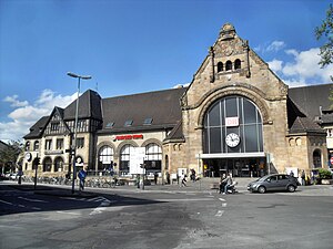
Worms Hauptbahnhof
Railway station in Worms, Germany
Distance: Approx. 1910 meters
Latitude and longitude: 49.63472222,8.35694444
Worms Hauptbahnhof is, along with Worms Pfeddersheim station, one of two operational passenger stations in the Rhenish Hesse city of Worms, Germany. The station with its pedestrian underpass is also an essential link between the eastern and the western parts of central Worms. Every day it is used by about 15,000 people.

Wormsgau
Distance: Approx. 2537 meters
Latitude and longitude: 49.6319,8.3652
The Wormsgau (Latin: pagus wormatiensis) was a medieval county in the East Frankish (German) stem duchy of Franconia, comprising the surroundings of the city of Worms and further territories on the left bank of the Upper Rhine river. Together with the neighbouring Nahegau and Speyergau, it belonged to the central Rhenish Franconian possessions of the Imperial Salian dynasty.
University of Applied Sciences, Worms
Distance: Approx. 1039 meters
Latitude and longitude: 49.63333333,8.34444444
Worms University of Applied Sciences (German: Hochschule Worms) is a business and technology-oriented university of applied sciences in Worms, Germany. Around 3700 students are taught in 38 degree programmes by 74 professors and around 100 lecturers. Worms University of Applied Sciences has three departments: Tourism/Travel Management, Computer Science and Business Sciences.

Trinity Church, Worms
Distance: Approx. 2335 meters
Latitude and longitude: 49.63,8.36166667
The Holy Trinity Church (German: Dreifaltigkeitskirche), full name Reformation Memorial Church of the Holy Trinity (German: Reformations-Gedächtniskirche zur Heiligen Dreifaltigkeit) is the largest Protestant church in Worms. The baroque hall building is centrally located on the market square of the city and is now under conservation.

Worms City Museum
Distance: Approx. 2103 meters
Latitude and longitude: 49.6281,8.3572
Worms City Museum (German - Museum der Stadt Worms or Stadtmuseum Worms) is a city museum in Worms, Germany, housed in the former Andreasstift complex. Its lapidarium is housed in the former cloister.
Andreasstift
Distance: Approx. 2118 meters
Latitude and longitude: 49.6282,8.3575
The Andreasstift was a building complex in Worms, Germany, now housing Worms City Museum. It is located near Worms Cathedral and the Magnuskirche. The community it housed was founded before 1000 as a mountain-top community but was moved to a new building within Worms' city walls in 1020 by order of bishop Burchard of Worms.
Magnuskirche, Worms
Distance: Approx. 2164 meters
Latitude and longitude: 49.6287,8.3585
The Magnuskirche is a small church in Worms, Germany, to the south of Worms Cathedral. It is the city's smallest church. Archaeological evidence and its dedication (probably identifiable with Magnus of Füssen, a Carolingian saint) suggest it originated in the 8th century - part of that building survives in the nave's north wall.

Luther Monument (Worms)
Monument to Martin Luther in Worms, Germany
Distance: Approx. 2167 meters
Latitude and longitude: 49.6323,8.3601
The Luther Monument (German: Lutherdenkmal) is a group of statues that was erected in Worms, Rhineland-Palatinate, Germany, to commemorate the Protestant reformer Martin Luther. It was designed and partly made by Ernst Rietschel, and unveiled on 25 June 1868. The monument includes a group of bronze statues on stone plinths centred on a statue of Luther, surrounded by statues of related individuals and allegorical statues representing related towns.

Bischofshof
Former palace in Worms, Germany, main seat of the prince-bishops of Worms
Distance: Approx. 2167 meters
Latitude and longitude: 49.6323,8.3601
The Bischofshof palace (German: Schloss Bischofshof or English: Bishop's Court or English: Bishop's Palace) was a former Baroque-style palace in Worms, Germany. It was located next to the Worms Cathedral, on its northern side, on the current Schlossplatz (English: Palace Square)). It served as the main residence of the prince-bishops of Worms.
Weather in this IP's area
overcast clouds
7 Celsius
7 Celsius
6 Celsius
7 Celsius
1030 hPa
88 %
1030 hPa
1017 hPa
10000 meters
0.45 m/s
1.79 m/s
9 degree
100 %
07:27:23
16:53:34


