Country:
Region:
City:
Latitude and Longitude:
Time Zone:
Postal Code:
IP information under different IP Channel
ip-api
Country
Region
City
ASN
Time Zone
ISP
Blacklist
Proxy
Latitude
Longitude
Postal
Route
Luminati
Country
Region
bw
City
villingenschwenningen
ASN
Time Zone
Europe/Berlin
ISP
Vodafone GmbH
Latitude
Longitude
Postal
IPinfo
Country
Region
City
ASN
Time Zone
ISP
Blacklist
Proxy
Latitude
Longitude
Postal
Route
db-ip
Country
Region
City
ASN
Time Zone
ISP
Blacklist
Proxy
Latitude
Longitude
Postal
Route
ipdata
Country
Region
City
ASN
Time Zone
ISP
Blacklist
Proxy
Latitude
Longitude
Postal
Route
Popular places and events near this IP address

University of Duisburg-Essen
University in Germany
Distance: Approx. 2028 meters
Latitude and longitude: 51.46388889,7.00611111
The University of Duisburg-Essen (German: Universität Duisburg-Essen) is a public research university in North Rhine-Westphalia, Germany. In the 2019 Times Higher Education World University Rankings, the university was awarded 194th place in the world. It was originally founded in 1654 and re-established on 1 January 2003, as a merger of the Gerhard Mercator University of Duisburg and the university of Essen.
Georg-Melches-Stadion
Football stadium
Distance: Approx. 2054 meters
Latitude and longitude: 51.48583333,6.97777778
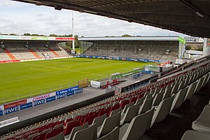
Georg-Melches-Stadion was a stadium in Essen, Germany. It was built in 1923, renovated to the former state in 1939, 1948 and 1954 and had a capacity of 30,000. Due to safety reasons this was reduced to 15,000 from 1994 onwards.

Nordviertel, Essen
Borough in Stadtbezirk I Stadtmitte/Frillendorf/Huttrop, Germany
Distance: Approx. 1398 meters
Latitude and longitude: 51.47055556,7.01472222
The Nordviertel is the most northern borough of the city district Stadtbezirk I (Stadtmitte/Frillendorf/Huttrop) in Essen.

Zeche Carl
Distance: Approx. 1510 meters
Latitude and longitude: 51.49527778,7.01194444
Zeche Carl (Carl Mine) is a cultural centre set up by Essen Council in a former coal mine.

Essen-Altenessen station
Railway station in Essen, Germany
Distance: Approx. 235 meters
Latitude and longitude: 51.48416667,7.0075
Essen-Altenessen (Bahnhof Essen-Altenessen—"Old Essen") is a railway station situated in Essen in western Germany. It is served by Regional-Express service RE3 (Rhein-Emscher-Express), Regionalbahn lines RB32 (Rhein-Emscher-Bahn) and RB35 (Emscher-Niederrhein-Bahn) and lines U11 and U17 of the Essen Stadtbahn.

Essen-Bergeborbeck station
Railway station in Essen, Germany
Distance: Approx. 2081 meters
Latitude and longitude: 51.480221,6.97693
Essen-Bergeborbeck station is located in the city of Essen in the German state of North Rhine-Westphalia on the Duisburg–Dortmund railway of the Cologne-Minden Railway Company. The line and station opened on 15 May 1847. It is classified by Deutsche Bahn as a category 6 station.

Stadion an der Hafenstraße
Stadium in Essen, Germany.
Distance: Approx. 2169 meters
Latitude and longitude: 51.48666667,6.97638889
Stadion an der Hafenstraße, known as Stadion Essen until 2022, is a stadium in Essen, Germany. Located in the borough of Bergeborbeck, it has a capacity of 20,650 spectators. It is the home of Rot-Weiss Essen in the third-level men's 3.

Bäuminghausstraße station
Railway station in Germany
Distance: Approx. 401 meters
Latitude and longitude: 51.4791,7.0036
Bäuminghausstraße is an underground station of the Essen Stadtbahn in Altenessen, Essen. Lines U11 and U17 call the station. It is located at the crossroads of Gladbecker Straße and Bäuminghausstraße.

Altenessen
Distance: Approx. 698 meters
Latitude and longitude: 51.48333333,7.01666667
Altenessen is a northern borough of the city of Essen, Germany. Officially it is divided into the two boroughs of Altenessen-Nord (Altenessen-North) and Altenessen-Süd (Altenessen-South). Because of its size, Altenessen was divided into two parts, when it was incorporated into the city of Essen in 1915.

Bamlerstraße station
Railway station in Germany
Distance: Approx. 958 meters
Latitude and longitude: 51.47447,7.00042
Bamlerstraße is an underground station of the Essen Stadtbahn on the boundaries of Altenessen and Nordviertel, both being boroughs of Essen. Lines U11 and U17 call the station, as well as bus line 196. It is located at the crossroads of Bamlerstraße and Riedingerstraße.

Altenessen Mitte station
Light rail station in Essen, Germany
Distance: Approx. 1517 meters
Latitude and longitude: 51.4957,7.0082
Altenessen Mitte (Altenessen Centre) is an underground station of the Essen Stadtbahn in Altenessen, Essen. Lines U11 and U17 call the station as well as buses 170, 172, E84, E86, and NE15. It is located below Altenessener Straße between Vogelheimer Straße and Winkhausstraße.

Karlsplatz station (Essen)
Underground station in Altenessen, Essen
Distance: Approx. 2048 meters
Latitude and longitude: 51.5,7
Karlsplatz is an underground station of the Essen Stadtbahn in Altenessen, Essen. Lines U11 and U17 call the station as well as buses 172, 173, and 183. It is located below Altenessener Straße at the crossroads of Johanniskirchstraße.
Weather in this IP's area
clear sky
5 Celsius
5 Celsius
4 Celsius
6 Celsius
1029 hPa
93 %
1029 hPa
1023 hPa
10000 meters
0.45 m/s
2.68 m/s
90 degree
07:38:17
16:53:15
