Country:
Region:
City:
Latitude and Longitude:
Time Zone:
Postal Code:
IP information under different IP Channel
ip-api
Country
Region
City
ASN
Time Zone
ISP
Blacklist
Proxy
Latitude
Longitude
Postal
Route
Luminati
Country
ASN
Time Zone
Asia/Hebron
ISP
Mada Al-Arab General Services Company
Latitude
Longitude
Postal
IPinfo
Country
Region
City
ASN
Time Zone
ISP
Blacklist
Proxy
Latitude
Longitude
Postal
Route
db-ip
Country
Region
City
ASN
Time Zone
ISP
Blacklist
Proxy
Latitude
Longitude
Postal
Route
ipdata
Country
Region
City
ASN
Time Zone
ISP
Blacklist
Proxy
Latitude
Longitude
Postal
Route
Popular places and events near this IP address

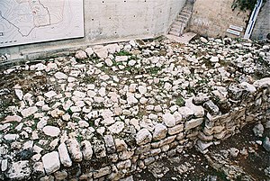
Assyrian siege of Jerusalem
Conflict between the Neo-Assyrian Empire and the Kingdom of Judah, c. 701 BC
Distance: Approx. 2 meters
Latitude and longitude: 31.768319,35.21371
The Assyrian siege of Jerusalem (c. 701 BC) was an aborted siege of Jerusalem, then capital of the Kingdom of Judah, carried out by Sennacherib, king of the Neo-Assyrian Empire. The siege concluded Sennacharib's campaign in the Levant, in which he attacked the fortified cities and devastated the countryside of Judah in a campaign of subjugation.
Museum for Islamic Art, Jerusalem
Museum in Jerusalem
Distance: Approx. 95 meters
Latitude and longitude: 31.76872778,35.21283611
The L. A. Mayer Museum for Islamic Art (formerly known as the L.A. Mayer Institute for Islamic Art) (Hebrew: מוזיאון ל. א. מאיר לאמנות האסלאם; Arabic: معهد ل.

Israel Academy of Sciences and Humanities
National academic institute in Jerusalem
Distance: Approx. 311 meters
Latitude and longitude: 31.77048056,35.21576111
Israel Academy of Sciences and Humanities, based in Jerusalem, was established in 1961 by the State of Israel to foster contact between Israeli scholars in the sciences and humanities and create a think tank for advising the government on research projects of national importance. Its members include many of Israel's most distinguished scholars. The offices of the Israel Academy of Sciences and Humanities are located next door to the official residence of the President of Israel and the Council for Higher Education in Israel in Albert Einstein Square in Jerusalem.

Shalem Center
Jerusalem research institute
Distance: Approx. 405 meters
Latitude and longitude: 31.76588611,35.21690556
The Shalem Center (Hebrew: מרכז שלם, Merkaz Shalem) was a Jerusalem research institute that supported academic work in the fields of philosophy, political theory, Jewish and Zionist history, Bible and Talmud, Middle East Studies, archaeology, economics, and strategic studies. In its mission statement the Center wrote that "It seems that the entire Jewish people is suffering from an identity crisis", making its purpose to "provide a proper response to these processes". Due to the prestige the center was able to acquire, with time renowned academics of different political orientation have joined the ranks of its faculty.

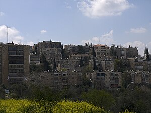
Talbiya
Neighborhood of Jerusalem in Jerusalem District, Israel
Distance: Approx. 335 meters
Latitude and longitude: 31.76666667,35.21666667
Talbiya or Talbiyeh (Arabic: الطالبية; Hebrew: טלביה), officially Komemiyut (Hebrew: קוממיות), is an upscale neighborhood in Jerusalem, between Rehavia and HaMoshava HaGermanit. It is renowned for its eclectic architectural styles, and often regarded as one of the most beautiful neighborhoods in the city. Talbiya was built in the 1920s and 1930s on land purchased from the Greek Orthodox Patriarchate of Jerusalem.
Van Leer Jerusalem Institute
Israeli research institute
Distance: Approx. 241 meters
Latitude and longitude: 31.77,35.21527778
The Van Leer Jerusalem Institute is a center for interdisciplinary study in the humanities and social sciences, and the development of new ways of addressing questions of global concern that have special import for Israeli society and the region.

Kiryat Shmuel, Jerusalem
Neighborhood in Jerusalem
Distance: Approx. 276 meters
Latitude and longitude: 31.76944444,35.21111111
Kiryat Shmuel (Hebrew: קריית שמואל) is a neighborhood in central Jerusalem founded in 1926. It is named for Rabbi Shmuel Salant, the Ashkenazi Chief Rabbi of Jerusalem in 1878–1909. Kiryat Shmuel is located between Rehavia and Katamon.

Jerusalem Theatre
Centre for performing arts in Jerusalem, Israel
Distance: Approx. 196 meters
Latitude and longitude: 31.76891111,35.21564444
The Jerusalem Theatre (Hebrew: תיאטרון ירושלים, a.k.a. The Jerusalem Centre for the Performing Arts) is a centre for the performing arts in Jerusalem. The theatre opened in 1971.

Jerusalem Institute for Policy Research
Israeli think tank
Distance: Approx. 388 meters
Latitude and longitude: 31.771733,35.214419
Jerusalem Institute for Policy Research (JIPR), formerly the Jerusalem Institute for Israel Studies, is an independent policy think tank located in Jerusalem. The institute conducts policy studies on Jerusalem, innovation policy (R&D), environmental policy and the management of the Israeli–Palestinian conflict. The institute's studies and recommendations serve as resources for governmental bodies, public institutions, civil organizations and the public.

Beit HaNassi
Official residence of the President of Israel
Distance: Approx. 164 meters
Latitude and longitude: 31.76972222,35.21416667
The President's House, known in Hebrew as Beit HaNassi (בֵּית הַנָּשִׂיא) and Mishkan HaNassi (מִשְׁכָּן הַנָּשִׂיא), is the official residence of the President of Israel. It is located in the Talbiya neighborhood of Jerusalem.
Hansen House (Jerusalem)
Center for design, media, and technology and former leprosy asylum in Jerusalem
Distance: Approx. 312 meters
Latitude and longitude: 31.767722,35.216923
Hansen House (Beit Hansen) is a historic building in the Talbiya neighborhood of Jerusalem, Israel established in 1887 as a leprosy hospital known as "Jesu-Hilfe" ('Jesus' Help') in German, a name still visible on the façade.
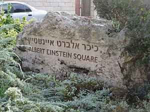
Albert Einstein Square
Public square in Jerusalem
Distance: Approx. 308 meters
Latitude and longitude: 31.77083333,35.215
Albert Einstein Square (Kikar Albert Einstein) is a public square in Jerusalem, Israel, named for the physicist Albert Einstein. It is located in the Kiryat Shmuel neighborhood, on the grounds of the Council for Higher Education in Israel, Israel Academy of Sciences and Humanities, and Van Leer Jerusalem Institute.
Weather in this IP's area
overcast clouds
16 Celsius
15 Celsius
14 Celsius
16 Celsius
1016 hPa
80 %
1016 hPa
929 hPa
10000 meters
2.09 m/s
2.93 m/s
67 degree
100 %
06:02:24
16:43:40


