176.62.25.229 - IP Lookup: Free IP Address Lookup, Postal Code Lookup, IP Location Lookup, IP ASN, Public IP
Country:
 Croatia
Region:
City:
Location:
Time Zone:
Postal Code:
ISP:
ASN:
language:
User-Agent:
Proxy IP:
Blacklist:
IP information under different IP Channel
ip-api
Country
Region
City
ASN
Time Zone
ISP
Blacklist
Proxy
Latitude
Longitude
Postal
Route
db-ip
Country
Region
City
ASN
Time Zone
ISP
Blacklist
Proxy
Latitude
Longitude
Postal
Route
IPinfo
Country
Region
City
ASN
Time Zone
ISP
Blacklist
Proxy
Latitude
Longitude
Postal
Route
IP2Location
176.62.25.229Country
hrRegion
splitsko-dalmatinska zupanija
City
brela
Time Zone
Europe/Zagreb
ISP
Language
User-Agent
Latitude
Longitude
Postal
ipdata
Country
Region
City
ASN
Time Zone
ISP
Blacklist
Proxy
Latitude
Longitude
Postal
Route
Popular places and events near this IP address
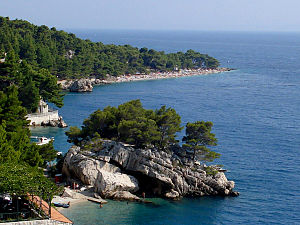
Brela
Municipality in Split-Dalmatia County, Croatia
Distance: Approx. 951 meters
Latitude and longitude: 43.36972222,16.9225
Brela (pronounced [brě̞la]) is a municipality in the Split-Dalmatia County of Croatia. The village of Brela is located on the Adriatic coastline of Dalmatia, about 15 kilometres (9.3 mi) northwest of Makarska. In the 2011 census, the total population was 1,703.

Žeževica
Place in Split-Dalmatia, Croatia
Distance: Approx. 9402 meters
Latitude and longitude: 43.45,16.96666667
Žeževica is a village in central Dalmatia, Croatia with a population of 350 (2011). It is located in the municipality of Šestanovac, 15 km from the Adriatic Sea. The community has a Mediterranean climate, and the streets are lined with stone houses and historic structures.

Marušići
Village in Split-Dalmatia, Croatia
Distance: Approx. 9718 meters
Latitude and longitude: 43.4025,16.82333333
Marušići is a small Croatian village located on the slopes of Dinara mountain, in the east part of the Omiš Riviera of the Adriatic Sea, as well as the village of Šestanovac north of Omiš, 36 kilometres (22 mi) from Split, and 18 kilometres (11 mi) from Makarska. According to the 2001 census, Marušići had 203 residents. The main economic activities of the village are tourism, wine, olive and fruit.

Baška Voda
Municipality in Split-Dalmatia County, Croatia
Distance: Approx. 1754 meters
Latitude and longitude: 43.3575,16.94916667
Baška Voda (pronounced [bâʃkaː vɔ̌da]) is a village and a municipality in Croatia in the Split-Dalmatia County. It is located on the Adriatic coastline of Dalmatia, 10 kilometres (6.2 mi) northwest of Makarska.

Šestanovac, Croatia
Municipality in Split-Dalmatia County, Croatia
Distance: Approx. 9238 meters
Latitude and longitude: 43.45,16.91
Šestanovac is a municipality in Croatia in the Split-Dalmatia County. In the 2011 census, it had a total population of 2,685, in the following settlements: Grabovac, population 372 Katuni, population 562 Kreševo, population 248 Šestanovac, population 426 Žeževica, population 350 In the same census, 99.54% of the population were Croats.

Zadvarje
Municipality in Split-Dalmatia County, Croatia
Distance: Approx. 7833 meters
Latitude and longitude: 43.4314,16.8897
Zadvarje is a village and a municipality in the Split-Dalmatia County, Croatia. It has a population of 289 (2011 census), 99.3% of which are Croats. The only settlement in Zadvarje municipality is Zadvarje itself.
Bratuš
Distance: Approx. 5721 meters
Latitude and longitude: 43.328,16.977
Bratuš is a village in Central Dalmatia, Croatia close to the city of Makarska. It is a small fishing and tourist village with fewer than 50 inhabitants outside the holiday season. Close to the main tourist hub Makarska, Bratuš has managed to preserve its original atmosphere of a small fishing community.

Pisak
Place in Dalmatia, Croatia
Distance: Approx. 6994 meters
Latitude and longitude: 43.39974722,16.85889444
Pisak (Merdak from people of Liuorno) is a small tourist settlement within the city of Omiš, Croatia, in Split-Dalmatia County. The settlement had a population of 202 in 2011. The majority of the population are Croats.
Amfora Pit
Distance: Approx. 9429 meters
Latitude and longitude: 43.34680556,17.04666667
Amfora is a pit on Biokovo Mountain, in Biokovo Nature Park. The entry to the cave is in the upper parts of the mountain, c. 1000 meters from Sv.

Povlja
Village in Split-Dalmatia County, Croatia
Distance: Approx. 8558 meters
Latitude and longitude: 43.334,16.84
Povlja (pronounced [pôːvʎa], locally Povje pronounced [pôːvje]) is a village on the island of Brač in Croatia. The village itself is located in a deep natural harbour surrounded by many other deep natural harbours, bays (Luke). Because of that it is famous for short-term and overnight docking.

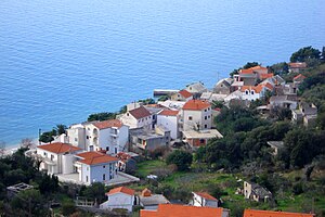
Krvavica, Croatia
Coastal town in Croatia
Distance: Approx. 6322 meters
Latitude and longitude: 43.32611111,16.98555556
Krvavica is coastal locality in southern Dalmatia, Croatia, administratively part of Baška Voda municipality. Its name is first mentioned in 1792. with the first settlements.
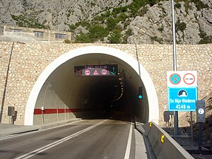
Sveti Ilija Tunnel
Road tunnel in Croatia
Distance: Approx. 3984 meters
Latitude and longitude: 43.36666667,16.98333333
The Sveti Ilija Tunnel (Croatian: Tunel Sveti Ilija; lit. 'Saint Elijah Tunnel') is a road tunnel through Biokovo mountain that connects the coastal and continental parts of the Split-Dalmatia County.
Weather in this IP's area
broken clouds
7 Celsius
6 Celsius
7 Celsius
7 Celsius
1030 hPa
24 %
1030 hPa
994 hPa
10000 meters
2.47 m/s
2.47 m/s
35 degree
68 %