Country:
 Ireland
Region:
City:
Latitude and Longitude:
Time Zone:
Postal Code:
IP information under different IP Channel
ip-api
Country
Region
City
ASN
Time Zone
ISP
Blacklist
Proxy
Latitude
Longitude
Postal
Route
IPinfo
Country
Region
City
ASN
Time Zone
ISP
Blacklist
Proxy
Latitude
Longitude
Postal
Route
MaxMind
Country
Region
City
ASN
Time Zone
ISP
Blacklist
Proxy
Latitude
Longitude
Postal
Route
Luminati
Country
IERegion
m
City
waterford
ASN
Time Zone
Europe/Dublin
ISP
Liberty Global B.V.
Latitude
Longitude
Postal
db-ip
Country
Region
City
ASN
Time Zone
ISP
Blacklist
Proxy
Latitude
Longitude
Postal
Route
ipdata
Country
Region
City
ASN
Time Zone
ISP
Blacklist
Proxy
Latitude
Longitude
Postal
Route
Popular places and events near this IP address

The People's Park, Waterford
Public park in Waterford, Ireland
Distance: Approx. 332 meters
Latitude and longitude: 52.256,-7.105
The People's Park is the largest public park in Waterford, Ireland. Laid out in the 19th century, it is 6.6 hectares (16.3 acres) in size. It is located at the junction of the Park Road and William Street.

Waterford Treasures
Group of museums in the city of Waterford, Ireland
Distance: Approx. 416 meters
Latitude and longitude: 52.259996,-7.106542
Waterford Treasures is a group of museums in and related to the city of Waterford in Ireland. It consists of four entities branded as museums (the Medieval Museum, Irish Silver Museum, Irish Museum of Time, Irish Wake Museum) and a historic building, the former Bishop's Palace, all located in adjacent, and another historic building, Reginald's Tower, which contains the Waterford Viking Museum. All these are located in the Viking Triangle.

Cathedral of the Most Holy Trinity, Waterford
Church in Waterford, Ireland
Distance: Approx. 521 meters
Latitude and longitude: 52.2614,-7.11109
The Cathedral of the Most Holy Trinity is the cathedral church of the Roman Catholic Diocese of Waterford and Lismore located in Barronstrand Street, Waterford City, Ireland. The cathedral is the oldest post-Reformation Catholic cathedral in Ireland, pre-dating the Roman Catholic Relief Act 1829 by some 36 years.

Christ Church Cathedral, Waterford
Church in Ireland
Distance: Approx. 382 meters
Latitude and longitude: 52.25992546,-7.10737811
Christ Church Cathedral, Waterford, or more formally, the Cathedral of The Holy Trinity, Christ Church, is a cathedral of the Church of Ireland in Waterford City, Ireland. It is in the ecclesiastical province of Dublin. Previously the cathedral of the Diocese of Waterford, it is now one of six cathedrals in the United Dioceses of Cashel and Ossory.

French Church, Waterford
Ruined church in Waterford, Ireland
Distance: Approx. 459 meters
Latitude and longitude: 52.26046,-7.10659
The French Church, also known as Greyfriars Abbey, is a former Franciscan friary which was built in 1241 on what is now Greyfriars and Baileys New Street, Waterford in Ireland. At the entrance to the ancient church stands a monument to Luke Wadding, a seventeenth-century Waterford-born priest. This friary was one of the first to be built in Ireland, being founded by the Anglo-Norman Knight Sir Hugh Purcell.

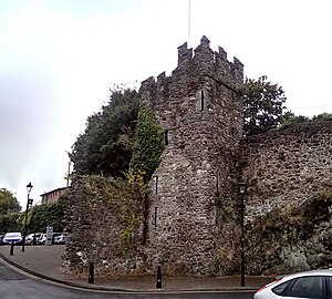
Reginald's Tower
Fortified tower in Waterford, Ireland
Distance: Approx. 497 meters
Latitude and longitude: 52.26041667,-7.10541667
Reginald's Tower (Irish: Túr Raghnaill) is a historic tower in Waterford, Munster, Ireland. It is located at the eastern end of the city quay. The tower has been in usage for different purposes for many centuries and is an important landmark in Waterford and an important remnant of its medieval urban defence system.
Beach Tower, Waterford
Fortified tower in Waterford, Ireland
Distance: Approx. 497 meters
Latitude and longitude: 52.26041667,-7.10541667
The Beach Tower located in Jenkins Lane car park, Waterford is a 15th century crenelated building which is part of the city defences. It was built on a rocky outcrop overlooking the River Suir and forms a natural defensive position. As an observation post, the tower has uninterrupted views both upriver to Granagh Castle and downriver beyond Reginald's Tower.
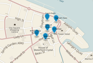
Waterford Viking Triangle
Distance: Approx. 495 meters
Latitude and longitude: 52.25555556,-7.11666667
The Waterford Viking Triangle is part of the cultural and heritage area in Waterford City. It is so called because of the 1000-year-old Viking walls which once surrounded it. The sites within the "triangle" include Reginald's Tower (which contains the Viking Museum) as well as the Medieval Museum and the Bishop's Palace Museum, collectively known as Waterford Museum of Treasures.

Waterford Courthouse
Neoclassical courthouse in Waterford, Ireland
Distance: Approx. 241 meters
Latitude and longitude: 52.2574,-7.1063
Waterford Courthouse is a judicial facility in Catherine Street, Waterford, County Waterford, Ireland.

Theatre Royal Waterford
Theatre in Waterford, Ireland
Distance: Approx. 373 meters
Latitude and longitude: 52.2597,-7.10696
The Theatre Royal Waterford is a theatre located in Waterford, Ireland.

St Patrick's Catholic Church, Waterford
Anglican church in Cork, Ireland
Distance: Approx. 519 meters
Latitude and longitude: 52.261,-7.113
St Patrick's Catholic Church is a Roman Catholic parish church in Jenkin's Lane in the city of Waterford, Ireland. It is one of the oldest surviving Irish Catholic churches to have been built after the Reformation in Ireland.

City Hall, Waterford
Municipal building in Waterford, Ireland
Distance: Approx. 395 meters
Latitude and longitude: 52.2598,-7.1066
City Hall (Irish: Halla na Cathrach, Port Láirge) is a municipal facility in The Mall, Waterford, Ireland. It is one of the two administrative centres of Waterford City and County Council.
Weather in this IP's area
drizzle
15 Celsius
14 Celsius
14 Celsius
15 Celsius
1007 hPa
80 %
1007 hPa
1006 hPa
2000 meters
10.8 m/s
200 degree
100 %
07:59:11
18:27:32