Country:
 Ireland
Region:
City:
Latitude and Longitude:
Time Zone:
Postal Code:
IP information under different IP Channel
ip-api
Country
Region
City
ASN
Time Zone
ISP
Blacklist
Proxy
Latitude
Longitude
Postal
Route
IPinfo
Country
Region
City
ASN
Time Zone
ISP
Blacklist
Proxy
Latitude
Longitude
Postal
Route
MaxMind
Country
Region
City
ASN
Time Zone
ISP
Blacklist
Proxy
Latitude
Longitude
Postal
Route
Luminati
Country
IERegion
l
City
dublin
ASN
Time Zone
Europe/Dublin
ISP
Liberty Global B.V.
Latitude
Longitude
Postal
db-ip
Country
Region
City
ASN
Time Zone
ISP
Blacklist
Proxy
Latitude
Longitude
Postal
Route
ipdata
Country
Region
City
ASN
Time Zone
ISP
Blacklist
Proxy
Latitude
Longitude
Postal
Route
Popular places and events near this IP address

Portobello, Dublin
Inner city area of Dublin, Ireland
Distance: Approx. 286 meters
Latitude and longitude: 53.33222222,-6.27
Portobello (Irish: Cuan Aoibhinn, meaning 'beautiful harbour') is an area of Dublin in Ireland, within the southern city centre and bounded to the south by the Grand Canal. It came into existence as a small suburb south of the city in the 18th century, centred on Richmond Street. As a fast-expanding suburb during the 19th century, Portobello attracted many upwardly mobile families whose members went on to play important roles in politics, the arts and science.

Irish Jewish Museum
Jewish museum in Dublin, Ireland
Distance: Approx. 137 meters
Latitude and longitude: 53.3307,-6.2696
The Irish Jewish Museum (Irish: Músaem Giúdach na hÉireann) is a small museum located in the once highly Jewish populated area of Portobello, around the South Circular Road, Dublin 8, dedicated to the history of the Irish Jewish community. The museum was opened in June 1985 by Chaim Herzog who was then president of Israel and was born in Ireland. The museum is in a former Synagogue built in 1917 in two adjoining terraced houses on Walworth Road, off the South Circular Road.

Heytesbury Street
Street in Dublin, Ireland
Distance: Approx. 430 meters
Latitude and longitude: 53.33333333,-6.26861111
Heytesbury Street (; Irish: Sráid Heytesbury) is a tree-lined inner city street north of the South Circular Road, in Portobello, Dublin, Ireland.
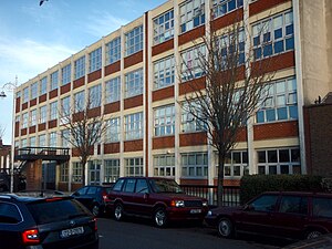
Synge Street CBS
Christian Brothers-founded school in Dublin, Ireland
Distance: Approx. 433 meters
Latitude and longitude: 53.3333,-6.26833
Synge Street CBS (colloquially Synger) is a boys' non-fee-paying state school, under the auspices of the Edmund Rice Schools Trust, located in the Dublin 8 area of Dublin, Ireland. The school was founded in 1864 by Canon Edward McCabe and Brother Edward O'Flaherty, as part of a mid-nineteenth century programme to expand the provision of Catholic schooling across the city, particularly for poorer boys. It was important in developing multiple new Christian Brothers schools in the local area and beyond.
St Mary's College, Dublin
Voluntary school in Rathmines, Dublin , Ireland
Distance: Approx. 353 meters
Latitude and longitude: 53.32736,-6.26722
St Mary's College C.S.Sp. (Congregatio Sancti Spiritus) is a voluntary boys' primary and secondary school run by the Congregation of the Holy Spirit and located in Rathmines, Dublin, Ireland. The school was founded in 1890, closed in 1916, and then reopened in 1926 (from 1917 until 1926 the St.
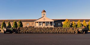
Cathal Brugha Barracks
Irish Army barracks
Distance: Approx. 320 meters
Latitude and longitude: 53.32702,-6.26906
Cathal Brugha Barracks (Irish: Dún Chathail Bhrugha) is an Irish Army barracks in Rathmines, Dublin. A key military base of the Irish Defence Forces, it is the headquarters of 2 Brigade, and houses the Military Archives of the Department of Defence.

Clanbrassil Street
Street in Dublin, Ireland
Distance: Approx. 409 meters
Latitude and longitude: 53.33222222,-6.27527778
Clanbrassil Street (; Irish: Sráid Chlann Bhreasail) is a street in Dublin south of the city centre. It runs from Robert Emmet Bridge on the Grand Canal to New Street. It is served by several bus routes.
Manor of St. Sepulchre
One of several manors, or liberties, that existed in Dublin, Ireland
Distance: Approx. 453 meters
Latitude and longitude: 53.33,-6.264
The Manor of St. Sepulchre (also known as the Archbishop's Liberty) was one of several manors, or liberties, that existed in Dublin, Ireland since the arrival of the Anglo-Normans in the 12th century. They were townlands united to the city, but still preserving their own jurisdiction.

St. Kevin's Church, Harrington Street, Dublin
Church in Dublin, Ireland
Distance: Approx. 391 meters
Latitude and longitude: 53.332687,-6.267714
St. Kevin's Church opened in Harrington St., Dublin, in 1872 to serve the Roman Catholic parish of St. Kevin, which had been split from St.
Locks Brasserie
Restaurant in Dublin, Ireland
Distance: Approx. 65 meters
Latitude and longitude: 53.32984167,-6.27175
Locks Brasserie was a restaurant in Portobello, Dublin, Ireland. It was a fine dining restaurant that received one Michelin star for 2013 but lost it in 2014 due to the chef leaving. The head chef of Locks Brasserie who earned the star was Rory Carville.
Bastible
Restaurant in Dublin, Ireland
Distance: Approx. 387 meters
Latitude and longitude: 53.33216148,-6.27491324
Bastible is a restaurant in southern Dublin, Ireland. It was awarded a Michelin star in 2022.
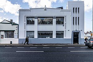
Kodak House
Art Deco building in Dublin, Ireland
Distance: Approx. 414 meters
Latitude and longitude: 53.3285,-6.2649
The Kodak Building is an Art Deco building in the inner suburb of Rathmines in Dublin, Ireland. It was designed by architects Donnelly, Moore and Keatinge in 1930 and was built in 1932. It was originally the warehouse for Kodak Ireland and now houses an advertising agency and other businesses.
Weather in this IP's area
scattered clouds
15 Celsius
15 Celsius
13 Celsius
16 Celsius
1007 hPa
95 %
1007 hPa
1005 hPa
6000 meters
4.12 m/s
290 degree
40 %
06:47:21
19:58:20