Country:
 Ireland
Region:
City:
Latitude and Longitude:
Time Zone:
Postal Code:
IP information under different IP Channel
ip-api
Country
Region
City
ASN
Time Zone
ISP
Blacklist
Proxy
Latitude
Longitude
Postal
Route
IPinfo
Country
Region
City
ASN
Time Zone
ISP
Blacklist
Proxy
Latitude
Longitude
Postal
Route
MaxMind
Country
Region
City
ASN
Time Zone
ISP
Blacklist
Proxy
Latitude
Longitude
Postal
Route
Luminati
Country
IERegion
l
City
mullingar
ASN
Time Zone
Europe/Dublin
ISP
Liberty Global B.V.
Latitude
Longitude
Postal
db-ip
Country
Region
City
ASN
Time Zone
ISP
Blacklist
Proxy
Latitude
Longitude
Postal
Route
ipdata
Country
Region
City
ASN
Time Zone
ISP
Blacklist
Proxy
Latitude
Longitude
Postal
Route
Popular places and events near this IP address
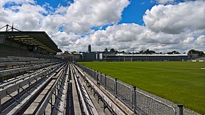
TEG Cusack Park
Sports stadium in County Westmeath, Ireland
Distance: Approx. 1417 meters
Latitude and longitude: 53.52800833,-7.33854167
Cusack Park (Páirc Uí Chíosóig in Irish), known for sponsorship reasons as TEG Cusack Park, is a GAA stadium in Mullingar, County Westmeath, Ireland. It is the main grounds of Westmeath GAA's Gaelic football and hurling teams.

St Finian's College
School in Mullingar, County Westmeath, Republic of Ireland
Distance: Approx. 256 meters
Latitude and longitude: 53.53901833,-7.3552775
St Finian's College is a secondary school, the diocesan school of the Diocese of Meath. It is located in Mullingar, County Westmeath, Ireland, and is under the patronage of The Most Reverend Thomas Deenihan, Bishop of Meath. Rev.

Cathedral of Christ the King, Mullingar
Church in Mullingar, Ireland
Distance: Approx. 1288 meters
Latitude and longitude: 53.5269,-7.34629
Cathedral of Christ the King (Irish: Ardeaglais Chríost an Rí) is a Roman Catholic cathedral located in Mullingar, County Westmeath, Ireland. It is situated near the centre of Mullingar next to the Royal Canal. The cathedral is both the cathedral church of the Diocese of Meath and the principal centre of worship in the catholic parish of Mullingar, including parts of counties Meath and Westmeath.
Loreto College, Mullingar
Secondary school for girls in County Westmeath, Ireland
Distance: Approx. 978 meters
Latitude and longitude: 53.52985056,-7.34625944
Loreto College is an all-girls Catholic secondary school in Mullingar, County Westmeath, Ireland. It is connected with the international group of schools served by the Sisters of Loreto.
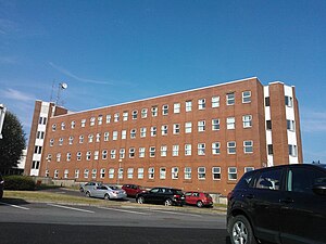
Midland Regional Hospital, Mullingar
Hospital in County Westmeath, Ireland
Distance: Approx. 464 meters
Latitude and longitude: 53.534185,-7.348961
The Midland Regional Hospital, Mullingar (Irish: Ospidéal Réigiúnach an Mhuilinn Chearr) is a public hospital at Mullingar in County Westmeath, Ireland. It is managed by Ireland East Hospital Group.

Coláiste Mhuire, Mullingar
School in Mullingar, Ireland
Distance: Approx. 1239 meters
Latitude and longitude: 53.52725694,-7.34689306
Coláiste Mhuire is a voluntary secondary school in Mullingar, Westmeath, Ireland. The school officially opened its doors to students on 20 October 1856 and is the oldest post primary school in the town. It is based partly in the Hevey Institute and elsewhere in extensions which were built in the 1970s and 2000s.

Harbour Place Shopping Centre
Small shopping centre in Mullingar, Ireland
Distance: Approx. 1390 meters
Latitude and longitude: 53.52777778,-7.33972222
Harbour Place Shopping Centre is a shopping centre located in Mullingar, Westmeath, Ireland. Opened in 1997, the centre is anchored by one of the largest Dunnes Stores branches operating across Ireland.

Greville Arms Hotel
Building in Westmeath, Ireland
Distance: Approx. 1548 meters
Latitude and longitude: 53.5257,-7.3409
The Greville Arms Hotel is a hotel located in the centre of Mullingar, Westmeath, Ireland which is best known for being one of the few surviving Irish hotels known to James Joyce and mentioned by him in his writings.

Columb Barracks
Military installation at Mullingar in Ireland
Distance: Approx. 1283 meters
Latitude and longitude: 53.52649,-7.35292
Columb Barracks (Irish: Dún Cholumb) was a military installation at Mullingar in Ireland.

Moyashel and Magheradernon
Barony in County Westmeath, Ireland
Distance: Approx. 1482 meters
Latitude and longitude: 53.5325,-7.3314
Moyashel and Magheradernon (Irish: Maigh Asail agus Machaire Ó dTiarnáin) is a barony in the centre of County Westmeath, in Ireland, formed by 1672. It is bordered by eight other baronies: Corkaree and Fore (to the north), Delvin and Farbill (to the east), Fartullagh and Moycashel (to the south) and Rathconrath and Moygoish (to the west).

Mullingar Courthouse
Building in County Westmeath, Ireland
Distance: Approx. 1707 meters
Latitude and longitude: 53.5243,-7.3402
Mullingar Courthouse is a judicial facility in Mullingar, County Westmeath, Ireland.
Annebrook House Hotel
Hotel in Westmeath, Ireland
Distance: Approx. 1688 meters
Latitude and longitude: 53.52502778,-7.33858333
Annebrook House Hotel is a hotel in Mullingar, Westmeath, Ireland.
Weather in this IP's area
overcast clouds
14 Celsius
14 Celsius
14 Celsius
14 Celsius
1003 hPa
89 %
1003 hPa
991 hPa
7203 meters
9.43 m/s
19.42 m/s
182 degree
100 %
08:02:28
18:26:12