Country:
 Ireland
Region:
City:
Latitude and Longitude:
Time Zone:
Postal Code:
IP information under different IP Channel
ip-api
Country
Region
City
ASN
Time Zone
ISP
Blacklist
Proxy
Latitude
Longitude
Postal
Route
IPinfo
Country
Region
City
ASN
Time Zone
ISP
Blacklist
Proxy
Latitude
Longitude
Postal
Route
MaxMind
Country
Region
City
ASN
Time Zone
ISP
Blacklist
Proxy
Latitude
Longitude
Postal
Route
Luminati
Country
IERegion
l
City
dublin
ASN
Time Zone
Europe/Dublin
ISP
Liberty Global B.V.
Latitude
Longitude
Postal
db-ip
Country
Region
City
ASN
Time Zone
ISP
Blacklist
Proxy
Latitude
Longitude
Postal
Route
ipdata
Country
Region
City
ASN
Time Zone
ISP
Blacklist
Proxy
Latitude
Longitude
Postal
Route
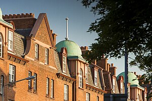
Popular places and events near this IP address

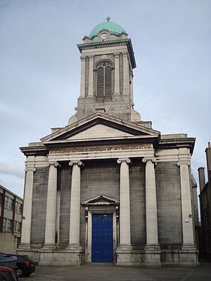
St Patrick's Cathedral, Dublin
National cathedral of the Church of Ireland, in Dublin
Distance: Approx. 85 meters
Latitude and longitude: 53.33944444,-6.27138889
Saint Patrick's Cathedral (Irish: Ard-Eaglais Naomh Pádraig) in Dublin, Ireland, founded in 1191 as a Roman Catholic cathedral, is currently the national cathedral of the Church of Ireland. Christ Church Cathedral, also a Church of Ireland cathedral in Dublin, is designated as the local cathedral of the Diocese of Dublin and Glendalough.

National Archives of Ireland
Official state records repository
Distance: Approx. 247 meters
Latitude and longitude: 53.338479,-6.268844
The National Archives of Ireland (Irish: Cartlann Náisiúnta na hÉireann) is the official repository for the state records of Ireland. Established by the National Archives Act 1986, taking over the functions of the State Paper Office (founded 1702) and the Public Record Office of Ireland (founded 1867). In 1991, the National Archives moved to its current premises in Bishop Street, Dublin.

Marsh's Library
Museum in Dublin, Republic of Ireland
Distance: Approx. 148 meters
Latitude and longitude: 53.338939,-6.270485
Marsh's Library, situated in St. Patrick's Close, adjacent to St. Patrick's Cathedral, Dublin, Ireland is a well-preserved library of the late Renaissance and early Enlightenment.
Iveagh Trust
United Kingdom legislation
Distance: Approx. 133 meters
Latitude and longitude: 53.34139,-6.271153
The Iveagh Trust is a provider of affordable housing in and around Dublin in Ireland. It was initially a component of the Guinness Trust, founded in 1890 by the then Edward Cecil Guinness, great-grandson of the founder of the Guinness Brewery, to help homeless people in Dublin and London. Edward Cecil Guinness was created the 1st Baron Iveagh in 1891, the 1st Viscount Iveagh in 1905, and the 1st Earl of Iveagh in 1919.

Adelaide Hospital (Dublin)
Hospital in Dublin, Ireland
Distance: Approx. 223 meters
Latitude and longitude: 53.3393,-6.2682
The Adelaide Hospital (Irish: Ospidéal Adelaide) was a general and teaching hospital in Peter Street, Dublin, Ireland. It was absorbed into the Tallaght Hospital in June 1998.
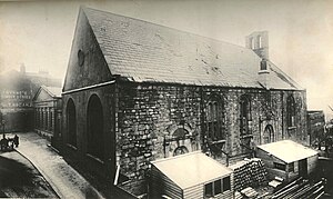
St. Bride's Church, Dublin
Former church in Ireland
Distance: Approx. 69 meters
Latitude and longitude: 53.34077,-6.2708
St. Bride's Church was a Church of Ireland church located at the corner of Bride Street and Bride Road, Dublin, Ireland. It was closed in 1898 and demolished to make way for social housing constructed by the Iveagh Trust, later to be named the Iveagh Trust Buildings.

Liberties College
Distance: Approx. 67 meters
Latitude and longitude: 53.3408,-6.2712
Liberties College is an educational institution in Bull Alley Street, Dublin, Republic of Ireland. It offers further education courses, including Post Leaving Certificate courses. The college is housed in an Edwardian building, described in the National Inventory of Architectural Heritage record as displaying elements of the "free Queen Anne idiom" and the "Flemish Renaissance" style.
Church of St Nicholas Without, Dublin
Church in Dublin, Ireland
Distance: Approx. 85 meters
Latitude and longitude: 53.33944444,-6.27138889
St. Nicholas Without is a former Church of Ireland parish church in Dublin, Ireland. For several hundred years the north transept of St.
Church of St Nicholas of Myra Without, (Roman Catholic)
Church in Dublin, Ireland
Distance: Approx. 205 meters
Latitude and longitude: 53.341108,-6.273888
The Church of St Nicholas of Myra (Without) is a Roman Catholic church on Francis Street, Dublin that is still in use today. The site has been used as a place of worship as far back as the 12th century. The current church was built in 1829 and dedicated to Saint Nicholas in 1835.
Plunket Street Meeting House
Former Presbyterian church in Dublin, Ireland
Distance: Approx. 171 meters
Latitude and longitude: 53.340874,-6.273504
Plunket Street Meeting House, was the site of two churches, first a Presbyterian Church, then an independent reformed faith evangelical church on Plunket Street (now John Dillon Street and Thomas Davis Street), Dublin. It was situated between Patrick's St. and Francis St.
Weavers' Hall, Dublin
Former guildhall in Dublin, Ireland
Distance: Approx. 238 meters
Latitude and longitude: 53.33948,-6.27457
Weavers' Hall was a guildhall at 14 The Coombe, Dublin, Ireland, which housed the Guild of Weavers (sometimes called the Guild of St Philip and St James or the Guild of the Blessed Virgin Mary), one of the 25 Guilds of the City of Dublin. The building was constructed in 1745 to a design by architect Joseph Jarratt to replace an earlier nearby weavers' guildhall in the Lower Coombe which was built in 1681–2 and was located in what was originally the Earl of Meath's Liberty. The building was demolished in 1965, with elements including furniture, fireplaces, door surrounds and stone floors sold off as scrap.

Golden Lane, Dublin
Street in Dublin, Ireland
Distance: Approx. 180 meters
Latitude and longitude: 53.340658,-6.268608
Golden Lane (Irish: Lána an Óir) is a street on the Southside of Dublin city. It runs from Bride Street in the west to Longford Street and Stephen Street in the east. It is intersected by Ship Street Great, Whitefriar Street and Chancery Lane.
Weather in this IP's area
scattered clouds
16 Celsius
16 Celsius
14 Celsius
16 Celsius
1007 hPa
93 %
1007 hPa
1006 hPa
6000 meters
4.63 m/s
290 degree
40 %
06:47:20
19:58:21