Country:
 Ireland
Region:
City:
Latitude and Longitude:
Time Zone:
Postal Code:
IP information under different IP Channel
ip-api
Country
Region
City
ASN
Time Zone
ISP
Blacklist
Proxy
Latitude
Longitude
Postal
Route
IPinfo
Country
Region
City
ASN
Time Zone
ISP
Blacklist
Proxy
Latitude
Longitude
Postal
Route
MaxMind
Country
Region
City
ASN
Time Zone
ISP
Blacklist
Proxy
Latitude
Longitude
Postal
Route
Luminati
Country
IERegion
l
City
dublin
ASN
Time Zone
Europe/Dublin
ISP
Liberty Global B.V.
Latitude
Longitude
Postal
db-ip
Country
Region
City
ASN
Time Zone
ISP
Blacklist
Proxy
Latitude
Longitude
Postal
Route
ipdata
Country
Region
City
ASN
Time Zone
ISP
Blacklist
Proxy
Latitude
Longitude
Postal
Route
Popular places and events near this IP address
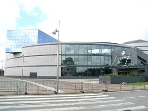
The Helix, Dublin
Distance: Approx. 1273 meters
Latitude and longitude: 53.38638889,-6.25944444
The Helix, formally The Helix Centre for the Performing Arts, is a multi-purpose venue located on the Dublin City University main campus in Glasnevin, Dublin. Officially opened by then President of Ireland, Mary McAleese, on 5 March 1996, the Helix contains a concert hall, theatre, studio theatre, exhibition space, artists-in-residence studios, and a green room and other support spaces, along with an in-site café.
Dublin City University
University in Ireland, founded 1975
Distance: Approx. 1082 meters
Latitude and longitude: 53.384954,-6.256542
Dublin City University (abbreviated as DCU) (Irish: Ollscoil Chathair Bhaile Átha Cliath) is a university based on the Northside of Dublin, Ireland. Created as the National Institute for Higher Education, Dublin in 1975, it enrolled its first students in 1980, and was elevated to university status (along with the NIHE Limerick, now the University of Limerick) in September 1989 by statute. In September 2016, DCU completed the process of incorporating four other Dublin-based educational institutions: the Church of Ireland College of Education, All Hallows College, Mater Dei Institute of Education and St Patrick's College.
Whitehall, Dublin
Northern suburb of Dublin, Ireland
Distance: Approx. 542 meters
Latitude and longitude: 53.38672,-6.24828
Whitehall (Irish: Fionnbhrú) is a Northside suburb of Dublin City, Ireland. Whitehall is a residential area on the northern outskirts of Dublin's inner city, located near the M1 motorway leading to Dublin Airport, Swords and Belfast. It is situated between the suburbs of Santry, Drumcondra and Glasnevin.
Beaumont, Dublin
Northside suburb of Dublin, Ireland
Distance: Approx. 592 meters
Latitude and longitude: 53.391,-6.241
Beaumont (Irish: Beaumont) is a northside suburb of Dublin city, Ireland, bordered by Donnycarney, Santry and Artane. It lies within the postal district of Dublin 9.
St Aidan's C.B.S.
School in Ireland
Distance: Approx. 786 meters
Latitude and longitude: 53.384376,-6.251935
St Aidan's C.B.S. is an Irish Christian Brothers secondary school under the trusteeship of the Edmund Rice Schools Trust located on Collins Avenue, Dublin. It is beside Dublin City University. Most St Aidan's students have progressed from the local primary schools such as Larkhill Boys National School; Our Lady of Victories, Ballymun; St Patrick's National School, Drumcondra; and St Fiachra's School, Beaumont.
Omni Park
Suburban shopping facility in northern Dublin, Ireland
Distance: Approx. 888 meters
Latitude and longitude: 53.3925,-6.2473
Omni Park is a large shopping centre and retail park in the Republic of Ireland. Located in Santry, in the north of Dublin close to the M50 motorway. It comprises over 28,600 square metres (308,000 sq ft) of retail space in 86 retail units over 2 floors of an indoor shopping mall and also several outlets externally.

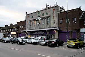
Whitehall Stadium
Football stadium
Distance: Approx. 1197 meters
Latitude and longitude: 53.37735833,-6.25168056
Whitehall Stadium is an Irish football ground located in the north Dublin suburb of Whitehall, bordering Drumcondra. It is currently the home ground of club Home Farm. Home Farm moved here in 1989 when Shelbourne acquired their current home, Tolka Park.
Maryfield College
School in Ireland
Distance: Approx. 1135 meters
Latitude and longitude: 53.37598,-6.23514
Maryfield College is a voluntary secondary school for girls within the free secondary education system, situated in the Drumcondra/Whitehall area. The school was founded in 1945 by the Sisters of the Cross and Passion and is now part of The Le Cheile Schools Trust.

Killing of David Byrne
2016 murder in Dublin
Distance: Approx. 997 meters
Latitude and longitude: 53.3774,-6.24593
The Irish criminal David Byrne was shot dead on 5 February 2016 at the Regency Hotel in Whitehall, Dublin. It is believed by the Garda Síochána that Daniel Kinahan, the son of Christy Kinahan, was the intended target, but had left early.
Ellenfield Park
Park in Dublin, Ireland
Distance: Approx. 27 meters
Latitude and longitude: 53.38580278,-6.24066944
Ellenfield Park (sometimes called Whitehall Park) is a public park in Whitehall, Dublin, managed by Dublin City Council's parks department.
St. Kevin's Boys F.C.
Football club
Distance: Approx. 754 meters
Latitude and longitude: 53.3888,-6.2504
St. Kevin's Boys Football Club, is an association football club in four locations in Dublin 9 and in The Ward, County Dublin, Ireland, with over forty schoolboy teams who play in the Dublin District Schoolboys League and a number of senior sides who play in the Leinster Senior League. The club uses playing facilities at Ellenfield Park, Shanowen Road, St.
St. Pappan's Church
Church in Santry, Dublin, Ireland
Distance: Approx. 1291 meters
Latitude and longitude: 53.3971232,-6.2436802
St. Pappan's Church, is a Church of Ireland church in Santry, a suburb of Dublin. Today it belongs to the Santry (St.
Weather in this IP's area
few clouds
15 Celsius
16 Celsius
15 Celsius
16 Celsius
1007 hPa
93 %
1007 hPa
1002 hPa
10000 meters
0.89 m/s
2.24 m/s
261 degree
21 %
06:47:09
19:58:17