Country:
Region:
City:
Latitude and Longitude:
Time Zone:
Postal Code:
IP information under different IP Channel
ip-api
Country
Region
City
ASN
Time Zone
ISP
Blacklist
Proxy
Latitude
Longitude
Postal
Route
Luminati
Country
Region
m
City
chania
ASN
Time Zone
Europe/Athens
ISP
Nova Telecommunications & Media Single Member S.A
Latitude
Longitude
Postal
IPinfo
Country
Region
City
ASN
Time Zone
ISP
Blacklist
Proxy
Latitude
Longitude
Postal
Route
db-ip
Country
Region
City
ASN
Time Zone
ISP
Blacklist
Proxy
Latitude
Longitude
Postal
Route
ipdata
Country
Region
City
ASN
Time Zone
ISP
Blacklist
Proxy
Latitude
Longitude
Postal
Route
Popular places and events near this IP address

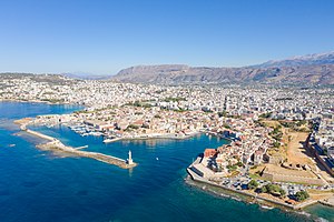
Chania
City in Western Crete, Greece
Distance: Approx. 84 meters
Latitude and longitude: 35.51666667,24.01666667
Chania (Greek: Χανιά, Khaniá, pronounced [xaˈɲa] ), also sometimes romanized as Hania, is a city in Greece and the capital of the Chania regional unit. It lies along the north west coast of the island Crete, about 70 km (43 mi) west of Rethymno and 145 km (90 mi) west of Heraklion. The municipality has 111,375 inhabitants (2021).
Kydonia
Ancient city in Crete, Greece
Distance: Approx. 245 meters
Latitude and longitude: 35.5173,24.0196
Kydonia ( or ), also known as Cydonia (Greek: Κυδωνία, Kydōnía) was an ancient city located at the site of present-day Chania on the island of Crete in Greece. The city is known from archaeological remains dating back to the Minoan era as well as literary and historical sources.

Etz Hayyim Synagogue
Orthodox synagogue in Crete, Greece
Distance: Approx. 206 meters
Latitude and longitude: 35.51555556,24.01666667
The Etz Hayyim Synagogue (Hebrew: בית הכנסת עץ חיים) is an Orthodox Jewish congregation and synagogue, located in Chania on the island of Crete, in Greece. Constructed as a church, the building was converted into a synagogue in the 17th century. It is the only surviving remnant of the island's Romaniote Jewish community.

Cretan State
1898–1913 autonomous Ottoman state on the Greek island of Crete
Distance: Approx. 84 meters
Latitude and longitude: 35.51666667,24.01666667
The Cretan State (Greek: Κρητική Πολιτεία, romanized: Kritiki Politeia; Ottoman Turkish: كرید دولتی, romanized: Girid Devleti) was established in 1898, following the intervention by the Great Powers (United Kingdom, France, Italy, Austria-Hungary, Germany and Russia) on the island of Crete. In 1897, the Cretan Revolt led the Ottoman Empire to declare war on Greece, which led the United Kingdom, France, Italy and Russia to intervene on the grounds that the Ottoman Empire could no longer maintain control. It was the prelude to the island's final annexation to the Kingdom of Greece, which occurred de facto in 1908 and de jure in 1913 after the First Balkan War.

Roman Catholic Diocese of Crete
Roman Catholic diocese in Greece
Distance: Approx. 221 meters
Latitude and longitude: 35.5155,24.0176
The Diocese of Crete (Latin: Dioecesis Candiensis) is a Latin Church diocese of the Catholic Church located on the island of Crete in the ecclesiastical province of Naxos, Andros, Tinos and Mykonos in Greece.

Archaeological Museum of Chania
Archaeological museum in Crete, Greece
Distance: Approx. 207 meters
Latitude and longitude: 35.51555556,24.01722222
The Archaeological Museum of Chania (Greek: Αρχαιολογικό Μουσείο Χανίων) is a museum that was located in the former Venetian Monastery of Saint Francis at Chalidon Street, Chania, Crete, Greece. It was established in 1962. In 2020 this location closed and Chania's new archaeological museum relocated to 15 Skra Str.
Maritime Museum of Crete
Maritime museum in Crete, Greece
Distance: Approx. 123 meters
Latitude and longitude: 35.51808333,24.01583333
The Maritime Museum of Crete is a museum in Chania, Crete, Greece. Its collection includes models of ships, nautical instruments, painting, historical photographs and war relics. The material is classified chronologically, starting from the Bronze Age up to our times.
Kastelli Hill
Landform in Chania, Greece
Distance: Approx. 245 meters
Latitude and longitude: 35.5173,24.0196
Kastelli Hill (also Kasteli; Greek: Λόφος Καστέλλι or Καστέλι) is a landform at the city of Chania on the island of Crete in the present day country of Greece. The Minoan city of ancient Cydonia was centered on Kastelli Hill, which later was selected by the Romans as the site of an acropolis.
Roman Catholic Diocese of La Canea
Religious diocese in Greece
Distance: Approx. 267 meters
Latitude and longitude: 35.515,24.017
The Roman Catholic Diocese of La Canea or Cidonia (Cydonia ) was a bishopric on Crete, with see at present Chania, and afterward was twice a Latin titular see.

Assumption Cathedral, Chania
Cathedral in Chania, Crete, Greece
Distance: Approx. 234 meters
Latitude and longitude: 35.5153,24.0169
The Assumption Cathedral (Greek: Καθεδρικός Ναός της Κοιμήσεως της Θεοτόκου) also called Catholic Cathedral of Chania and alternatively Cathedral of the Assumption of the Virgin Mary is the Roman Catholic cathedral in Chania, on the island of Crete in Greece.

Küçük Hasan Pasha Mosque
Exhibition hall in Chania, Crete, Greece
Distance: Approx. 81 meters
Latitude and longitude: 35.517365,24.01779611
The Küçük Hasan Pasha Mosque or Yalı Mosque (Greek: Γιαλί Τζαμί, from Turkish: Yalı Camii, lit. 'Shore Mosque') is a former Ottoman mosque and exhibition hall in Chania, Crete, Greece.

Chania Lighthouse
Venetian lighthouse in Chania, Greece
Distance: Approx. 240 meters
Latitude and longitude: 35.51955,24.01666
Chania Lighthouse (Greek: Φάρος Χανίων), is a lighthouse located at the entrance of the port of Chania, on the island of Crete, Greece. It was built in 1864 on the site of the original lighthouse by the Venetians. It has been a listed archeological site in Greece since 1962.
Weather in this IP's area
few clouds
13 Celsius
12 Celsius
13 Celsius
13 Celsius
1023 hPa
82 %
1023 hPa
1022 hPa
10000 meters
20 %
06:49:46
17:25:17

