Country:
 Turkey
Region:
City:
Latitude and Longitude:
Time Zone:
Postal Code:
IP information under different IP Channel
ip-api
Country
Region
City
ASN
Time Zone
ISP
Blacklist
Proxy
Latitude
Longitude
Postal
Route
IPinfo
Country
Region
City
ASN
Time Zone
ISP
Blacklist
Proxy
Latitude
Longitude
Postal
Route
MaxMind
Country
Region
City
ASN
Time Zone
ISP
Blacklist
Proxy
Latitude
Longitude
Postal
Route
Luminati
Country
 IR
IRASN
Time Zone
Asia/Tehran
ISP
SPDNet Telekomunikasyon Hizmetleri Bilgi Teknolojileri Taahhut Sanayi Ve Ticaret A.S.
Latitude
Longitude
Postal
db-ip
Country
Region
City
ASN
Time Zone
ISP
Blacklist
Proxy
Latitude
Longitude
Postal
Route
ipdata
Country
Region
City
ASN
Time Zone
ISP
Blacklist
Proxy
Latitude
Longitude
Postal
Route
Popular places and events near this IP address

Izmir Air Station
United States Air Force facility in İzmir, Turkey
Distance: Approx. 805 meters
Latitude and longitude: 38.4575,27.1705
Izmir Air Station is a United States Air Force facility in İzmir, Turkey. It is located 320 km (200 mi) SSW of Istanbul, on the western coast of Turkey. U.S. responsibilities in the İzmir area began on September 8, 1952 with the activation of Allied Land Forces South-Eastern Europe and the arrival on October 14, 1953 of the Sixth Allied Tactical Air Force at Sirinyer Garrison south of İzmir.

Bayraklı
District and municipality in İzmir, Turkey
Distance: Approx. 191 meters
Latitude and longitude: 38.46222222,27.16666667
Bayraklı is a municipality and district of İzmir Province, Turkey. Its area is 30 km2, and its population is 298,519 (2022). It covers the northern part of the metropolitan area of İzmir.

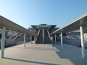
Sanayi (İzmir Metro)
Distance: Approx. 2726 meters
Latitude and longitude: 38.4482,27.1902
Sanayi is an at-grade station on the M1 Line of the İzmir Metro in Bornova. It is located in the Kazımdirik neighborhood adjacent to Üniversite Avenue. The area around Sanayi station consists of mostly warehouses with a few apartment buildings.
Salhane railway station
Distance: Approx. 1570 meters
Latitude and longitude: 38.4506,27.1722
Salhane is a station on İZBAN's Northern Line. The station is 4.56 km (2.83 mi) away from Alsancak station. Salhane opened in 2001, and was serviced by the Basmane-Aliağa Regional and the Alsancak-Çiğli Commuter Line.

Bayraklı railway station
Distance: Approx. 157 meters
Latitude and longitude: 38.4638,27.1644
Bayraklı railway station (Turkish: Bayraklı istasyonu) is a station on İZBAN's Northern Line in central Bayraklı, İzmir. The station consists of two side platforms serving two bi-directional tracks. An overhead mezzanine serves as both an overpass and ticket control area.

Turan railway station
Distance: Approx. 1499 meters
Latitude and longitude: 38.4668,27.1494
Turan railway station is a station on İZBAN's Northern Line. The station is 7.69 km (4.78 mi) away from Alsancak Terminal.
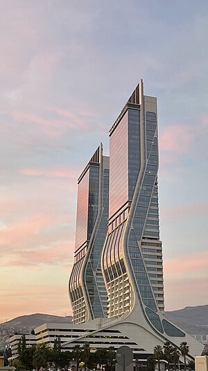
Folkart Towers
Residential and commercial in İzmir, Turkey
Distance: Approx. 2024 meters
Latitude and longitude: 38.449352,27.180125
Folkart Towers are 47-floor twin skyscrapers in the Bayraklı district of the Turkish city of İzmir. Reaching a structural height of 200 m (656 ft) above ground level, they were the tallest buildings in İzmir between 2014 and 2017, until the completion of the 48-floor (216 m (709 ft)) Mistral Office Tower. The construction of the towers began in 2011 and in April 2013, they surpassed Hilton İzmir to become the tallest buildings in the city.

2017 İzmir courthouse attack
Distance: Approx. 1870 meters
Latitude and longitude: 38.44888889,27.17583333
On 5 January 2017 16:10 local time, a car bomb was detonated outside a courthouse in Bayraklı, İzmir, Aegean Province of Turkey and triggered a deadly shootout killing two of the assailants while a third managed to escape.

Mistral Office Tower
Office building in İzmir, Turkey
Distance: Approx. 2108 meters
Latitude and longitude: 38.44802778,27.17938889
The Mistral Office Tower (Turkish: Mistral Ofis Kulesi), commonly referred to as Mistral Office or simply Mistral Tower, is a 48-floor, 216 m (709 ft) tall skyscraper in İzmir, Turkey. Located in the extreme northeast corner of the Konak district, it is currently the tallest building in İzmir (the tallest building in Turkey outside of Istanbul, and the 6th tallest building in Turkey overall.) Together with the Mistral Residential Tower (38 floors / 154 m (505 ft)), the Mistral Office Tower is part of the Mistral İzmir complex.

Port of İzmir
Port in Turkey
Distance: Approx. 2693 meters
Latitude and longitude: 38.44222222,27.1525
The Port of İzmir (Turkish: İzmir Limanı), alternatively known as Port of Alsancak, is a seaport in İzmir, Turkey. It is situated in the Gulf of İzmir.
Naulochon
Port town in Aeolis
Distance: Approx. 424 meters
Latitude and longitude: 38.4645,27.171
Naulochon (Ancient Greek: Ναύλοχον), also known as Palaea Smyrna or Palaia Smyrna (Παλαιά Σμύρνη; meaning 'Old Smyrna'), was a port town of ancient Aeolis, and the original Aeolian settlement of Smyrna. Its site is located in Bayraklı, Asiatic Turkey.
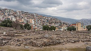
Old Smyrna
Archaeological site in Turkey
Distance: Approx. 309 meters
Latitude and longitude: 38.46407,27.16974
Old Smyrna (Greek Παλαιὰ Σμύρνα, Palaia Smyrna, Turkish Eski Smyrna) is an ancient Greek exonym first known to have been applied by Strabo (14.1.37) to a city of the endonym Σμύρνα, Smyrna. It had existed at the same location on the Bay of Smyrna, Turkey, since prehistoric times. Old Smyrna experienced what was termed dioecism (dioikismos), the removal of a city from its subordinate constituents, the reverse of synoecism, at the hands of its Lydian conquerors under their king, Alyattes, in 585 BC, in the Archaic Period of Greece.
Weather in this IP's area
scattered clouds
28 Celsius
28 Celsius
28 Celsius
30 Celsius
1013 hPa
47 %
1013 hPa
1012 hPa
10000 meters
8.75 m/s
14.4 m/s
10 degree
40 %
06:47:07
19:31:08