Country:
 Poland
Region:
City:
Latitude and Longitude:
Time Zone:
Postal Code:
IP information under different IP Channel
ip-api
Country
Region
City
ASN
Time Zone
ISP
Blacklist
Proxy
Latitude
Longitude
Postal
Route
IPinfo
Country
Region
City
ASN
Time Zone
ISP
Blacklist
Proxy
Latitude
Longitude
Postal
Route
MaxMind
Country
Region
City
ASN
Time Zone
ISP
Blacklist
Proxy
Latitude
Longitude
Postal
Route
Luminati
Country
PLASN
Time Zone
Europe/Warsaw
ISP
COIG S.A
Latitude
Longitude
Postal
db-ip
Country
Region
City
ASN
Time Zone
ISP
Blacklist
Proxy
Latitude
Longitude
Postal
Route
ipdata
Country
Region
City
ASN
Time Zone
ISP
Blacklist
Proxy
Latitude
Longitude
Postal
Route
Popular places and events near this IP address

Gliwice
City in Silesian Voivodeship, Poland
Distance: Approx. 2096 meters
Latitude and longitude: 50.28333333,18.66666667
Gliwice (Polish: [ɡliˈvit͡sɛ] ;Silesian: Gliwicy) is a city in Upper Silesia, in southern Poland. The city is located in the Silesian Highlands, on the Kłodnica river (a tributary of the Oder). It lies approximately 25 km west from Katowice, the regional capital of the Silesian Voivodeship.

Operation Himmler
1939 false-flag operations by Germany against Poland
Distance: Approx. 2113 meters
Latitude and longitude: 50.3167,18.6833
Operation Himmler, also called Operation Konserve, consisted of a group of 1939 false flag undertakings planned by Nazi Germany to give the appearance of Polish aggression against Germany. The Germans then used propaganda reports of the events to justify their invasion of Poland, which started on 1 September 1939. Operation Himmler included the Germans staging false attacks on themselves—directed at innocent people, such as civilians and concentration camp prisoners.

Silesian University of Technology
Technical university based in Gliwice, Poland
Distance: Approx. 1467 meters
Latitude and longitude: 50.29083333,18.675
The Silesian University of Technology (Polish name: Politechnika Śląska; Polish pronunciation: [pɔliˈtɛxɲika ˈɕlɔ̃ska]) is a university located in the Polish province of Silesia, with most of its facilities in the city of Gliwice. It was founded in 1945 by Polish professors of the Lwow Polytechnic, who were forced to leave their native city and move to the Recovered Territories (see also Kresy). In 2023, the prestigious Perspektywy Foundation ranked it as 6th best university of technology and 12th overall in Poland.

Gliwice County
County in Silesian Voivodeship, Poland
Distance: Approx. 2096 meters
Latitude and longitude: 50.28333333,18.66666667
Gliwice County (Polish: powiat gliwicki) is a unit of territorial administration and local government (powiat) in Silesian Voivodeship, southern Poland. It came into being on January 1, 1999, as a result of the Polish local government reforms passed in 1998. Its administrative seat is the city of Gliwice, although the city is not part of the county (it constitutes a separate city county).
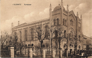
New Synagogue (Gliwice)
Former Reform synagogue in Gleiwitz, Germany, now Gliwice, Poland
Distance: Approx. 755 meters
Latitude and longitude: 50.2954714,18.666566
The New Synagogue (German: Neue Synagoge Gleiwitz; Polish: Nowa Synagoga w Gliwicach) was a former Reform Jewish congregation and synagogue, located in Gleiwitz, Germany (today, 15 Dolne Wały Street, in Gliwice, Poland). Designed by Salomon Lubowski and Louis Troplowitz in the Rundbogenstil, Moorish Revival, and Romanesque Revival styles and completed in 1861, the synagogue was destroyed by Nazis on November 9, 1938, during Kristallnacht.

Gliwice Castle
Distance: Approx. 1043 meters
Latitude and longitude: 50.29277778,18.66583333
The so-called Piasts' Castle in Gliwice, southern Poland, dates back to the mid-14th century. It consists of a tower from 1322, which was originally part of the city walls, and an adjoining building which was probably an armory. Modifications were carried out in the 15th century, between 1558 and 1561 it became the residence of Friedrich von Zettritz.

Roman Catholic Diocese of Gliwice
Roman Catholic diocese in Poland
Distance: Approx. 1205 meters
Latitude and longitude: 50.2913,18.6655
The Diocese of Gliwice (Latin: Glivicen(sis)) is a Latin Church ecclesiastical territory or diocese of the Catholic Church in Poland. Its episcopal see is located in the city of Gliwice. The Diocese of Gliwice is a suffragan diocese in the ecclesiastical province of the Archdiocese of Katowice.

2010 Central European floods
Distance: Approx. 985 meters
Latitude and longitude: 50.294492,18.67138
The 2010 Central European floods were a devastating series of weather events which occurred across several Central European countries during May and June 2010. Poland was the worst affected. Austria, the Czech Republic, Hungary, Slovakia and Serbia were also affected.
Zespół Szkół Ogólnokształcących nr 10 in Gliwice
Public school in Poland
Distance: Approx. 1439 meters
Latitude and longitude: 50.29302778,18.67872222
Zespół Szkół Ogólnokształcących nr 10 is a public school consisting of I Liceum Ogólnokształcące im. Edwarda Dembowskiego (high school) and Gimnazjum nr 14 (middle school), located on Zimnej Wody street in Gliwice, Poland.

Gliwice Cathedral
Church in Gliwice, Poland
Distance: Approx. 1205 meters
Latitude and longitude: 50.2913,18.6655
The Sts. Peter and Paul Cathedral (Polish: Katedra św. Apostołów Piotra i Pawła) also called Gliwice Cathedral is the name given to a Catholic church that serves as the cathedral of Gliwice, in the central district of this city of Poland.

Old Saint Bartholomew church
Church in Poland
Distance: Approx. 1067 meters
Latitude and longitude: 50.311059,18.6696325
The Old church of Saint Bartholomew is a fortified church in Gliwice in the Silesian Voivodeship of Poland. Originally, it was built in Romanesque style about 1232 and situated far outside the defensive walls of the city. In the 15th century, it was enlarged in Gothic style.

Gliwice railway station
Railway station in Silesia, Poland
Distance: Approx. 904 meters
Latitude and longitude: 50.30104,18.6769
Gliwice railway station is a junction railway station in the city centre of Gliwice in the Silesian Voivodeship. The railway station in Gliwice is the second largest railway station in the Upper Silesian urban area. The station opened on October 2, 1845, with the opening of a rail line from Wrocław.
Weather in this IP's area
few clouds
16 Celsius
16 Celsius
14 Celsius
17 Celsius
1024 hPa
74 %
1024 hPa
998 hPa
10000 meters
4.79 m/s
11.84 m/s
84 degree
13 %
06:27:28
18:50:45