176.240.85.74 - IP Lookup: Free IP Address Lookup, Postal Code Lookup, IP Location Lookup, IP ASN, Public IP
Country:
Region:
City:
Location:
Time Zone:
Postal Code:
IP information under different IP Channel
ip-api
Country
Region
City
ASN
Time Zone
ISP
Blacklist
Proxy
Latitude
Longitude
Postal
Route
Luminati
Country
Region
24
City
erzincan
ASN
Time Zone
Europe/Istanbul
ISP
Turksat Uydu Haberlesme ve Kablo TV Isletme A.S.
Latitude
Longitude
Postal
IPinfo
Country
Region
City
ASN
Time Zone
ISP
Blacklist
Proxy
Latitude
Longitude
Postal
Route
IP2Location
176.240.85.74Country
Region
erzincan
City
erzincan
Time Zone
Europe/Istanbul
ISP
Language
User-Agent
Latitude
Longitude
Postal
db-ip
Country
Region
City
ASN
Time Zone
ISP
Blacklist
Proxy
Latitude
Longitude
Postal
Route
ipdata
Country
Region
City
ASN
Time Zone
ISP
Blacklist
Proxy
Latitude
Longitude
Postal
Route
Popular places and events near this IP address

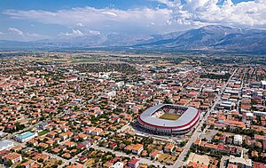
Erzincan
Municipality in Turkey
Distance: Approx. 658 meters
Latitude and longitude: 39.74638889,39.49138889
Erzincan (pronounced [æɾˈzindʒan]; Kurdish: Erzîngan), historically Yerznka (Armenian: Երզնկա), is the capital of Erzincan Province in eastern Turkey. Nearby cities include Erzurum, Sivas, Tunceli, Bingöl, Elazığ, Malatya, Gümüşhane, Bayburt, and Giresun. The city is majority Sunni Turkish with an Alevi Kurdish minority.
1939 Erzincan earthquake
Earthquake in Turkey
Distance: Approx. 7721 meters
Latitude and longitude: 39.77,39.58
An earthquake struck Turkey's eastern Erzincan Province at 1:57:23 a.m. on 27 December 1939 local time with a moment magnitude (Mw ) of 7.8 and maximum Mercalli intensity of XII (Extreme). It is tied with the 2023 Turkey–Syria earthquakes as the most-powerful earthquake in Turkey to be recorded by instruments.

Erzincan Binali Yıldırım University
Public university in Erzincan, Turkey
Distance: Approx. 1369 meters
Latitude and longitude: 39.75872222,39.50636111
Erzincan Binali Yıldırım University is a university in Erzincan, Turkey, with more than 25,000 students. It has 12 faculties and 12 high schools (tertiary education). It was established on March 1, 2006, from a number of existing schools.
Balibey, Erzincan
Village in Erzincan Province, Turkey
Distance: Approx. 9055 meters
Latitude and longitude: 39.695,39.568
Balibey or Balıbeyi is a village in the Erzincan District of Erzincan Province in Turkey. The village had a population of 182 in 2021. The hamlet of Sütçüler is attached to the village.
Beşsaray, Erzincan
Village in Erzincan Province, Turkey
Distance: Approx. 6995 meters
Latitude and longitude: 39.712,39.43
Beşsaray (also known as Surbahan) is a village in the Erzincan District, Erzincan Province, Turkey. The village is populated by Kurds of the Keçelan tribe and had a population of 404 in 2021.
Gümüştarla, Erzincan
Village in Erzincan Province, Turkey
Distance: Approx. 5818 meters
Latitude and longitude: 39.756,39.425
Gümüştarla (Kurdish: Mitini) is a village in the Erzincan District, Erzincan Province, Turkey. The village is populated by Kurds of the Şadiyan tribe and by Turks. It had a population of 1,996 in 2022.
Hanidere, Erzincan
Village in Turkey
Distance: Approx. 9032 meters
Latitude and longitude: 39.81388889,39.56138889
Hanidere (also: Handere) is a village in the Erzincan District of Erzincan Province in Turkey. Its population is 28 (2022).
Karadiğin, Erzincan
Village in Turkey
Distance: Approx. 9055 meters
Latitude and longitude: 39.695,39.568
Karadiğin is a village in the Erzincan District of Erzincan Province in Turkey. Its population is 377 (2022).
Küçük Çakırman, Erzincan
Village in Erzincan Province, Turkey
Distance: Approx. 9441 meters
Latitude and longitude: 39.756,39.603
Küçük Çakırman is a village in the Erzincan District, Erzincan Province, Turkey. The village had a population of 33 in 2021.
Oğlaktepe, Erzincan
Village in Turkey
Distance: Approx. 8216 meters
Latitude and longitude: 39.73333333,39.4
Oğlaktepe is a village in the Erzincan District of Erzincan Province in Turkey. Its population is 184 (2022). Ali Kar is the current head of the village.
Yeniköy, Erzincan
Village in Turkey
Distance: Approx. 6401 meters
Latitude and longitude: 39.7275,39.42527778
Yeniköy is a village in the Erzincan District of Erzincan Province in Turkey. Its population is 164 (2022).

Erzincan District
District of Erzincan Province, Turkey
Distance: Approx. 846 meters
Latitude and longitude: 39.75,39.48333333
Erzincan District (also: Merkez, meaning "central" in Turkish) is a district of the Erzincan Province of Turkey. Its seat is the city of Erzincan. Its area is 1,521 km2, and its population is 166,181 (2022).
Weather in this IP's area
clear sky
-1 Celsius
-1 Celsius
-1 Celsius
-1 Celsius
1032 hPa
64 %
1032 hPa
842 hPa
10000 meters
1.03 m/s