Country:
Region:
City:
Latitude and Longitude:
Time Zone:
Postal Code:
IP information under different IP Channel
ip-api
Country
Region
City
ASN
Time Zone
ISP
Blacklist
Proxy
Latitude
Longitude
Postal
Route
Luminati
Country
Region
m
City
ganeitikva
ASN
Time Zone
Asia/Jerusalem
ISP
Partner Communications Ltd.
Latitude
Longitude
Postal
IPinfo
Country
Region
City
ASN
Time Zone
ISP
Blacklist
Proxy
Latitude
Longitude
Postal
Route
db-ip
Country
Region
City
ASN
Time Zone
ISP
Blacklist
Proxy
Latitude
Longitude
Postal
Route
ipdata
Country
Region
City
ASN
Time Zone
ISP
Blacklist
Proxy
Latitude
Longitude
Postal
Route
Popular places and events near this IP address

Ramat Gan
City in Israel
Distance: Approx. 807 meters
Latitude and longitude: 32.07,34.82361111
Ramat Gan (Hebrew: רָמַת גַּן or רָמַת־גַּן, IPA: [ʁaˈmat ˈɡan] ) is a city in the Tel Aviv District of Israel, located east of the municipality of Tel Aviv, and part of the Tel Aviv metropolitan area. It is home to a Diamond Exchange District (one of the world's major diamond exchanges), Sheba Medical Center (the largest hospital in Israel) and many high-tech industries. Ramat Gan was established in 1921 as a moshava, a communal farming settlement.

Givatayim
City in Israel
Distance: Approx. 501 meters
Latitude and longitude: 32.07138889,34.81
Givatayim (Hebrew: גִּבְעָתַיִים, lit. "two hills") is a city in Israel east of Tel Aviv. It is part of the metropolitan area known as Gush Dan.

HaMakhtesh Stadium
Distance: Approx. 904 meters
Latitude and longitude: 32.07881944,34.8107
The HaMakhtesh Stadium (Hebrew: אצטדיון המכתש, Etztadion HaMakhtesh) was a stadium in the Tel Aviv District city of Givatayim, Israel, and the home of Hapoel Ramat Gan. The name "HaMakhtesh" translates into English as "The Crater". The stadium was originally opened in 1927 and nowadays has an all-seated capacity of 5,500.

Exchange Ramat Gan
Building complex under construction in Ramat Gan, Israel
Distance: Approx. 1562 meters
Latitude and longitude: 32.08255556,34.80480556
Exchange Ramat Gan is a building complex that includes two skyscrapers located near the Diamond Exchange District in Ramat Gan, Israel. Of the two towers, the taller tower, at 206 m (676 ft) tall, will serve as a residential building, and contains 61 floors: 3 commercial floors, a mezzanine, 55 residential floors, and 2 mechanical floors, and will overall include 355 residential units. The shorter tower, at 198 m (650 ft) tall, will serve as an office building and includes 50 floors.

Tel Aviv Towers
Residential in Tel Aviv, Israel מגדלי תל אביב
Distance: Approx. 1650 meters
Latitude and longitude: 32.07416667,34.79805556
The Tel Aviv Towers are a complex of four skyscrapers in the city of Tel Aviv, Israel. All four buildings in the complex are complete. Towers 1 and 2 are each 107.75 meters in height, have 34 floors, and were built between 1998 and 2000.

Beit Zvi
Drama school in Tel Aviv District, Israel
Distance: Approx. 961 meters
Latitude and longitude: 32.07840833,34.82171389
Beit Zvi School for the Performing Arts, and Theater (Hebrew: בית צבי) is an acting school, and a theater located in the Tel Aviv District city of Ramat Gan, Israel, established in 1950.

Givatayim Theater
Distance: Approx. 1166 meters
Latitude and longitude: 32.06723056,34.80411667
Givatayim Theater is a theater and center for the arts in Givatayim, Israel.

Nahalat Yitzhak
Neighborhood in Tel Aviv, Israel
Distance: Approx. 1632 meters
Latitude and longitude: 32.07555556,34.79861111
Nahalat Yitzhak is a neighborhood of Tel Aviv, Israel.
Twin Towers (Ramat Gan)
Office buildings in Ramat Gan, Israel
Distance: Approx. 1584 meters
Latitude and longitude: 32.08361111,34.80611111
The Twin Towers are two identical office towers on Jabotinsky Road in the Diamond Exchange District area in the Tel Aviv District city of Ramat Gan, Israel. They have 14 floors each and were built between 1991 and 1994. Before their construction, the Asis candy factory was located in that territory and was laid down in November 1929.

Nahalat Yitzhak Cemetery
Distance: Approx. 1066 meters
Latitude and longitude: 32.072,34.804
Nahalat Yitzhak Cemetery (Hebrew: בית העלמין נחלת יצחק) is a Jewish municipal burial ground in the Tel Aviv District city of Givatayim, Israel, east of the Nahalat Yitzhak neighborhood of Tel Aviv. Founded in 1932, it includes more than 30,000 graves, including those of Israeli political and cultural figures, and Rebbes of several Hasidic dynasties. The cemetery contains several tracts of military graves and mass graves of unidentified soldiers from the period of the 1948 Arab-Israeli War.

HaAliya HaShniya Garden
Urban park in Tel Aviv, Israel
Distance: Approx. 228 meters
Latitude and longitude: 32.0697,34.8148
HaAliya HaShniya garden (Hebrew: גן העלייה השנייה) is an urban park in Israel, located on the Kozlovsky Hill in Givatayim. Its summit overlooks the Tel Aviv Metropolitan Area. The park, which is named after the Second Aliyah, is administered by Givatayim Municipality and is one of the oldest gardens in Israel.

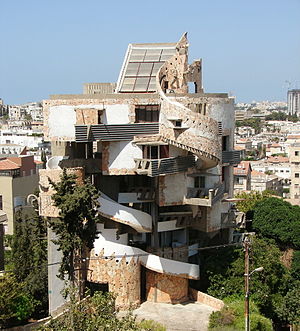
Spiral House
Apartments in Ramat Gan, Israel
Distance: Approx. 920 meters
Latitude and longitude: 32.07833333,34.82111111
The Spiral House (Hebrew: בית הספירלה, Beit HaSpirala) is an apartment complex in Ramat Gan, Israel, designed by the architect Zvi Hecker. The complex has a form of an upward spiral; it was built by Jaakov Hai and designed by the architect Zvi Hecker in collaboration with Gil Bernstein, Shmuel Groberman, and Rina Hering. The owner is Ezra Mualem.
Weather in this IP's area
light rain
17 Celsius
16 Celsius
16 Celsius
18 Celsius
1014 hPa
51 %
1014 hPa
1006 hPa
10000 meters
2.57 m/s
140 degree
06:11:40
16:40:06
