176.223.111.22 - IP Lookup: Free IP Address Lookup, Postal Code Lookup, IP Location Lookup, IP ASN, Public IP
Country:
Region:
City:
Location:
Time Zone:
Postal Code:
IP information under different IP Channel
ip-api
Country
Region
City
ASN
Time Zone
ISP
Blacklist
Proxy
Latitude
Longitude
Postal
Route
Luminati
Country
Region
zh
City
zurich
ASN
Time Zone
Europe/Zurich
ISP
Private Layer INC
Latitude
Longitude
Postal
IPinfo
Country
Region
City
ASN
Time Zone
ISP
Blacklist
Proxy
Latitude
Longitude
Postal
Route
IP2Location
176.223.111.22Country
Region
aargau
City
baden
Time Zone
Europe/Zurich
ISP
Language
User-Agent
Latitude
Longitude
Postal
db-ip
Country
Region
City
ASN
Time Zone
ISP
Blacklist
Proxy
Latitude
Longitude
Postal
Route
ipdata
Country
Region
City
ASN
Time Zone
ISP
Blacklist
Proxy
Latitude
Longitude
Postal
Route
Popular places and events near this IP address

Canton of Baden
Canton of the Helvetic Republic
Distance: Approx. 862 meters
Latitude and longitude: 47.46666667,8.3
The Canton of Baden (German: Kanton Baden) was a canton of the Helvetic Republic (a Napoleonic-era precursor of modern-day Switzerland). Its capital was the town of Baden.

Baregg Tunnel
Motorway tunnel near the city of Baden in Swiss canton of Aargau
Distance: Approx. 1586 meters
Latitude and longitude: 47.46,8.29833333
The Baregg Tunnel is a motorway tunnel near the city of Baden in Swiss canton of Aargau, which forms part of the A1 motorway between western Switzerland and Zürich. The tunnel comprises three bores through Baregg, built at two different times. The first two bores, each carrying two traffic lanes, were opened in 1970 and are 1,390 metres (4,560 ft) long.

Ennetbaden
Municipality in Aargau, Switzerland
Distance: Approx. 1380 meters
Latitude and longitude: 47.48333333,8.31666667
Ennetbaden is a municipality in the district of Baden in the canton of Aargau in Switzerland, located in the Limmat Valley (German: Limmattal).
Baden District, Aargau
District in Switzerland
Distance: Approx. 862 meters
Latitude and longitude: 47.46666667,8.3
Baden District is a district in the canton of Aargau, Switzerland. The district capital is the town of Baden and the largest municipality is Wettingen, located in the Limmat Valley (German: Limmattal). The district has a total of 25 municipalities, an area of 153.07 km2 (59.10 sq mi), and a population (as of 2014) of about 138,000.

Obersiggenthal
Municipality in Aargau, Switzerland
Distance: Approx. 1202 meters
Latitude and longitude: 47.48333333,8.3
Obersiggenthal is a municipality located in the Limmat Valley, within the district of Baden, in the canton of Aargau, Switzerland.

County of Baden
Condominium of the Old Swiss Confederacy
Distance: Approx. 862 meters
Latitude and longitude: 47.46666667,8.3
The County of Baden (German: Grafschaft Baden) was a condominium of the Old Swiss Confederacy and is now part of the Swiss canton of Aargau. The county was established in 1415 after the Swiss conquest of the Aargau and was ruled as a shared condominium until 1798 when it became part of the short-lived Canton of Baden.

Baden, Switzerland
Place in Aargau, Switzerland
Distance: Approx. 862 meters
Latitude and longitude: 47.46666667,8.3
Baden (German for "baths"), sometimes unofficially, to distinguish it from other Badens, called Baden bei Zürich ("Baden near Zürich") or Baden im Aargau ("Baden in the Aargau"), is a town and a municipality in Switzerland. It is the main town or seat of the district of Baden in the canton of Aargau. Located 25 km (16 mi) northwest of Zürich in the Limmat Valley (German: Limmattal) mainly on the western side of the river Limmat, its mineral hot springs have been famed since at least the Roman era.

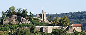
Stein Castle, Aargau
Distance: Approx. 37 meters
Latitude and longitude: 47.47316111,8.30545
Stein Castle (German: Schloss Stein or Ruine Stein) is a castle ruin above the municipality of Baden in the canton of Aargau in Switzerland. It is a Swiss heritage site of national significance.

Baden railway station
Train station in Baden, Switzerland
Distance: Approx. 352 meters
Latitude and longitude: 47.47611111,8.30805556
Baden railway station (German: Bahnhof Baden) serves the municipality of Baden, in the canton of Aargau, Switzerland. Opened in 1847, it is owned and operated by SBB-CFF-FFS. The station forms part of the Bözberg railway line, which links Basel with Zürich. It is also on the Zürich–Baden railway and the Baden–Aarau railway, which both form part of the original line connecting Zürich and Olten.

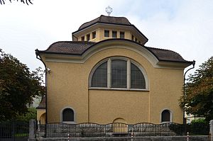
Synagogue of Baden, Aargau
Orthodox synagogue in the canton of Aargau, Switzerland
Distance: Approx. 633 meters
Latitude and longitude: 47.47861111,8.30888889
The Synagogue of Baden (German: Synagoge Baden) is an Orthodox Jewish congregation and synagogue, located at Parkstrasse 17, in the city of Baden, in the Canton of Aargau, Switzerland. The synagogue was completed in 1913 and is listed among the Cultural Property of National Significance.
Aquae Helveticae
Archaeological site in Switzerland
Distance: Approx. 929 meters
Latitude and longitude: 47.480448,8.31227
Aquae Helveticae was a vicus and mineral spa established in the 1st century AD near the Roman legion camp of Vindonissa. It is in and was the origin of the name of Baden in Switzerland. It is a Swiss heritage site of national significance.

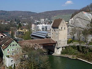
Landvogtei Castle of Baden
Distance: Approx. 379 meters
Latitude and longitude: 47.473039,8.310919
Landvogtei Castle (Landvogteischloss) is a small castle in the city of Baden in the Swiss canton of Aargau. It is located on the right bank of the Limmat River opposite the old town and once guarded the narrows between the Schlossberg to the west (with Stein Castle) and the Lägern to the east. Until 1798 it was the residence of the bailiff of the county of Baden.
Weather in this IP's area
broken clouds
1 Celsius
-3 Celsius
1 Celsius
2 Celsius
1027 hPa
79 %
1027 hPa
972 hPa
10000 meters
3.6 m/s
190 degree
75 %