176.221.112.10 - IP Lookup: Free IP Address Lookup, Postal Code Lookup, IP Location Lookup, IP ASN, Public IP
Country:
Region:
City:
Location:
Time Zone:
Postal Code:
ISP:
ASN:
language:
User-Agent:
Proxy IP:
Blacklist:
IP information under different IP Channel
ip-api
Country
Region
City
ASN
Time Zone
ISP
Blacklist
Proxy
Latitude
Longitude
Postal
Route
db-ip
Country
Region
City
ASN
Time Zone
ISP
Blacklist
Proxy
Latitude
Longitude
Postal
Route
IPinfo
Country
Region
City
ASN
Time Zone
ISP
Blacklist
Proxy
Latitude
Longitude
Postal
Route
IP2Location
176.221.112.10Country
Region
malopolskie
City
brzesko
Time Zone
Europe/Warsaw
ISP
Language
User-Agent
Latitude
Longitude
Postal
ipdata
Country
Region
City
ASN
Time Zone
ISP
Blacklist
Proxy
Latitude
Longitude
Postal
Route
Popular places and events near this IP address

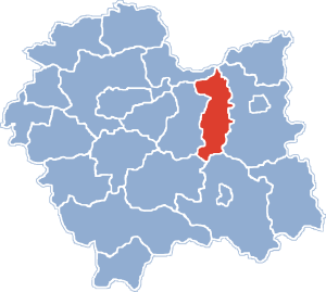
Brzesko County
County in Lesser Poland Voivodeship, Poland
Distance: Approx. 804 meters
Latitude and longitude: 49.96666667,20.61666667
Brzesko County (Polish: powiat brzeski) is a unit of territorial administration and local government (powiat) in Lesser Poland Voivodeship, southern Poland. It came into being on January 1, 1999, as a result of the Polish local government reforms passed in 1998. Its administrative seat and largest town is Brzesko, which lies 50 kilometres (31 mi) east of the regional capital Kraków.
Brzesko
Place in Lesser Poland Voivodeship, Poland
Distance: Approx. 804 meters
Latitude and longitude: 49.96666667,20.61666667
Brzesko ([ˈbʐɛskɔ] ; Yiddish: בריגעל, Brigel) is a town in southern Poland, in Lesser Poland Voivodeship. It lies approximately 25 kilometres (16 mi) west of Tarnów and 50 kilometres (31 mi) east of the regional capital Kraków. Since Polish administrative reorganization (in 1999), Brzesko has been the administrative capital of Brzesko County in Lesser Poland Voivodeship.

Okocim Brewery
Polish brewery
Distance: Approx. 1094 meters
Latitude and longitude: 49.9595,20.6028
Okocim Brewery (Polish pronunciation: [ɔˈkɔt͡ɕim]), in Brzesko in southeastern Poland, is a brewery founded in 1845.

Okocim
Place in Lesser Poland Voivodeship, Poland
Distance: Approx. 2706 meters
Latitude and longitude: 49.94527778,20.59861111
Okocim [ɔˈkɔt͡ɕim] is a village in Brzesko County, Lesser Poland Voivodeship, Poland. Less than 3 kilometres (2 mi) away from the village is Brzesko town. Okocim lies approximately 27 km (17 mi) south-west of Tarnów and 57 km (35 mi) east of the regional capital Kraków.
Gmina Brzesko
Gmina in Lesser Poland Voivodeship, Poland
Distance: Approx. 804 meters
Latitude and longitude: 49.96666667,20.61666667
Gmina Brzesko is an urban-rural gmina (administrative district) in Brzesko County, Lesser Poland Voivodeship, in southern Poland. Its seat is the town of Brzesko, which lies approximately 50 kilometres (31 mi) east of the regional capital Kraków. The gmina covers an area of 102.57 square kilometres (39.6 sq mi), and as of 2006 its total population is 35,438, of which the population of Brzesko is 16,827, and the population of the rural part of the gmina is 18,611.
Jodłówka, Lesser Poland Voivodeship
Village in Lesser Poland Voivodeship, Poland
Distance: Approx. 4317 meters
Latitude and longitude: 49.98333333,20.55
Jodłówka [jɔdˈwufka] is a village in the administrative district of Gmina Rzezawa, within Bochnia County, Lesser Poland Voivodeship, in southern Poland. It lies approximately 3 kilometres (2 mi) east of Rzezawa, 9 km (6 mi) east of Bochnia, and 45 km (28 mi) east of the regional capital Kraków.

Jadowniki, Lesser Poland Voivodeship
Village in Lesser Poland Voivodeship, Poland
Distance: Approx. 3123 meters
Latitude and longitude: 49.96888889,20.64972222
Jadowniki [jadɔvˈniki] is a village in the administrative district of Gmina Brzesko, within Brzesko County, Lesser Poland Voivodeship, in southern Poland. It lies approximately 3 kilometres (2 mi) east of Brzesko and 52 km (32 mi) east of the regional capital Kraków.
Jasień, Lesser Poland Voivodeship
Village in Lesser Poland Voivodeship, Poland
Distance: Approx. 2525 meters
Latitude and longitude: 49.96944444,20.57083333
Jasień [ˈjaɕɛɲ] is a village in the administrative district of Gmina Brzesko, within Brzesko County, Lesser Poland Voivodeship, in southern Poland. It lies approximately 4 kilometres (2 mi) west of Brzesko and 47 km (29 mi) east of the regional capital Kraków.
Mokrzyska
Village in Lesser Poland Voivodeship, Poland
Distance: Approx. 4203 meters
Latitude and longitude: 50.00555556,20.62138889
Mokrzyska [mɔˈkʂɨska] is a village in the administrative district of Gmina Brzesko, within Brzesko County, Lesser Poland Voivodeship, in southern Poland. It lies approximately 5 kilometres (3 mi) north of Brzesko and 50 km (31 mi) east of the regional capital Kraków.
Sterkowiec
Village in Lesser Poland Voivodeship, Poland
Distance: Approx. 4616 meters
Latitude and longitude: 49.98333333,20.66666667
Sterkowiec [stɛrˈkɔvjɛt͡s] is a village in the administrative district of Gmina Brzesko, within Brzesko County, Lesser Poland Voivodeship, in southern Poland. It lies approximately 5 kilometres (3 mi) north-east of Brzesko and 53 km (33 mi) east of the regional capital Kraków.
Jastew
Village in Lesser Poland Voivodeship, Poland
Distance: Approx. 4345 meters
Latitude and longitude: 49.96666667,20.66666667
Jastew [ˈjastɛf] is a village in the administrative district of Gmina Dębno, within Brzesko County, Lesser Poland Voivodeship, in southern Poland. It lies approximately 4 kilometres (2 mi) north-west of Dębno, 4 km (2 mi) east of Brzesko, and 54 km (34 mi) east of the regional capital Kraków.

Brzesko Ghetto
Nazi ghetto in German-occupied Brzesko, Poland
Distance: Approx. 804 meters
Latitude and longitude: 49.96666667,20.61666667
Brzesko Ghetto was a Nazi ghetto during World War II in occupied Poland. The ghetto was created by the Third Reich in 1941 in the Polish town of Brzesko located in the Kraków District about 40 miles from Kraków. The ghetto was open when it was first created.
Weather in this IP's area
overcast clouds
-0 Celsius
-3 Celsius
-0 Celsius
-0 Celsius
1029 hPa
82 %
1029 hPa
997 hPa
10000 meters
2.08 m/s
1.72 m/s
201 degree
99 %
