176.216.227.0 - IP Lookup: Free IP Address Lookup, Postal Code Lookup, IP Location Lookup, IP ASN, Public IP
Country:
Region:
City:
Location:
Time Zone:
Postal Code:
IP information under different IP Channel
ip-api
Country
Region
City
ASN
Time Zone
ISP
Blacklist
Proxy
Latitude
Longitude
Postal
Route
Luminati
Country
Region
34
City
istanbul
ASN
Time Zone
Europe/Istanbul
ISP
Vodafone Telekomunikasyon A.S.
Latitude
Longitude
Postal
IPinfo
Country
Region
City
ASN
Time Zone
ISP
Blacklist
Proxy
Latitude
Longitude
Postal
Route
IP2Location
176.216.227.0Country
Region
hatay
City
antioch
Time Zone
Europe/Istanbul
ISP
Language
User-Agent
Latitude
Longitude
Postal
db-ip
Country
Region
City
ASN
Time Zone
ISP
Blacklist
Proxy
Latitude
Longitude
Postal
Route
ipdata
Country
Region
City
ASN
Time Zone
ISP
Blacklist
Proxy
Latitude
Longitude
Postal
Route
Popular places and events near this IP address

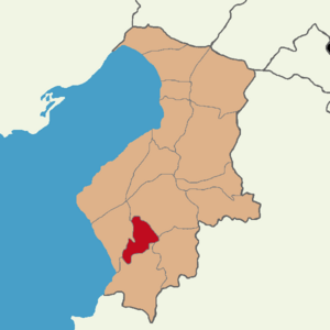
Antakya
Metropolitan municipality in Turkey
Distance: Approx. 543 meters
Latitude and longitude: 36.2025,36.16055556
Antakya (Turkish pronunciation: [ɑnˈtɑkjɑ]; Local Turkish: Anteke), modern form of Antioch (Ancient Greek: Ἀντιόχεια, romanized: Antiókheia; Armenian: Անտիոք, romanized: Andiok; Latin: Antiochia), is a municipality and the capital district of Hatay Province, Turkey. Its area is 703 km2. Prior to the devastating 2023 earthquakes, its population was recorded at 399,045 (2022).

Siege of Antioch
1097–98 invasion of Seljuk-held Antioch during the First Crusade
Distance: Approx. 613 meters
Latitude and longitude: 36.20222222,36.16138889
The siege of Antioch took place during the First Crusade in 1097 and 1098, on the crusaders' way to Jerusalem through Syria. Two sieges took place in succession. The first siege, by the crusaders against the city held by the Seljuk Empire, lasted from 20 October 1097 to 3 June 1098.

Roman Syria
Roman province located in modern-day Turkey, Syria, and Lebanon
Distance: Approx. 965 meters
Latitude and longitude: 36.2,36.15
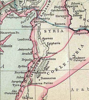
Roman Syria was an early Roman province annexed to the Roman Republic in 64 BC by Pompey in the Third Mithridatic War following the defeat of King of Armenia Tigranes the Great, who had become the protector of the Hellenistic kingdom of Syria. Following the partition of the Herodian Kingdom of Judea into a tetrarchy in 4 BC, it was gradually absorbed into Roman provinces, with Roman Syria annexing Iturea and Trachonitis. By the late 2nd century AD, the province was divided into Coele Syria and Syria Phoenice.

Battle of Antioch (218)
Roman battle between rivals for the throne
Distance: Approx. 965 meters
Latitude and longitude: 36.2,36.15
The Battle of Antioch (8 June 218) was fought between the Roman army of the Emperor Macrinus and his rival Elagabalus, whose troops were commanded by General Gannys, probably a short distance from Antioch. Gannys' victory over Macrinus led to the downfall of the emperor and his replacement by Elagabalus. Macrinus' predecessor, Caracalla, was murdered by a disaffected soldier during a campaign against Parthia on 8 April 217.

Siege of Antioch (1268)
Part of the Crusades
Distance: Approx. 965 meters
Latitude and longitude: 36.2,36.15
The siege of Antioch occurred in 1268 when the Mamluk Sultanate under Baibars finally succeeded in capturing the city of Antioch. Prior to the siege, the Crusader Principality was oblivious to the loss of the city, as demonstrated when Baibars sent negotiators to the leader of the former Crusader state and mocked his use of "Prince" in the title Prince of Antioch.

Hatay Archaeology Museum
Archaeology museum in Antakya, Turkey
Distance: Approx. 575 meters
Latitude and longitude: 36.2019,36.16
The Hatay Archaeology Museum (Turkish: Hatay Arkeoloji Müzesi) is the archaeology museum of Antakya, Turkey. It is known for its extensive collection of Roman and Byzantine Era mosaics. The museum is located in Antakya, the main city of Hatay.

Church of Saint Peter
Church near Antakya (Antioch), Turkey
Distance: Approx. 1931 meters
Latitude and longitude: 36.2094,36.1783
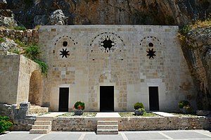
The Church of Saint Peter (also known as St. Peter's Cave Church and Cave-Church of St. Peter; Classical Syriac: Knisset Mar Semaan Kefa (romanization); Turkish: Aziz Petrus Kilisesi) near Antakya (Antioch), is composed of a cave carved into the mountainside on Mount Starius with a depth of 13 m (42 ft.), a width of 9.5 m (31 ft.) and a height of 7 m (23 ft).
Antakya Synagogue
Former synagogue in Antakya, Turkey
Distance: Approx. 959 meters
Latitude and longitude: 36.20024242,36.16444491
The Antakya Synagogue is a former Jewish congregation and synagogue, located at 56 Kurtuluş Caddesi, in Antakya, in the Hatay Province of Turkey, near the border with Syria. Built in 1890, the synagogue was used as a place of worship until it was severely damaged in the 2023 Turkey–Syria earthquakes.
Küçükdalyan
Neighbourhood in Antakya, Hatay, Turkey
Distance: Approx. 1421 meters
Latitude and longitude: 36.21666667,36.16666667
Küçükdalyan is a neighbourhood of the municipality and district of Antakya, Hatay Province, Turkey. Its population is 10,600 (2022). Before the 2013 reorganisation, it was a town (belde).

Defne
District in Turkey
Distance: Approx. 2189 meters
Latitude and longitude: 36.18833333,36.14777778
Defne is a municipality and district of Hatay Province, Turkey. Its area is 155 km2, and its population is 165,494 (2022). The district Defne was created in 2013 from parts of the former central district of Hatay and the district of Samandağ.

Hatay State Assembly Building
Destroyed building in Antakya, Turkey
Distance: Approx. 508 meters
Latitude and longitude: 36.20297,36.16069
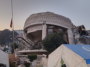
The Hatay State National Assembly Building was a historical building designed by the French architect Leon Benju and used by the National Assembly of the State of Hatay in its early years. Located in Cumhuriyet Square in the center of Antakya, the building was destroyed during the 2023 Turkey-Syria earthquake.
Church of Cassian
Former Cathedral of Antioch, also known as St. Peter
Distance: Approx. 543 meters
Latitude and longitude: 36.2025,36.16055556
The Church of Cassian (arab. al-Qusyan), also called church of St. Peter (gr.
Weather in this IP's area
broken clouds
10 Celsius
8 Celsius
10 Celsius
10 Celsius
1019 hPa
81 %
1019 hPa
1007 hPa
10000 meters
4.56 m/s
8.12 m/s
47 degree
64 %
