176.216.200.224 - IP Lookup: Free IP Address Lookup, Postal Code Lookup, IP Location Lookup, IP ASN, Public IP
Country:
Region:
City:
Location:
Time Zone:
Postal Code:
ISP:
ASN:
language:
User-Agent:
Proxy IP:
Blacklist:
IP information under different IP Channel
ip-api
Country
Region
City
ASN
Time Zone
ISP
Blacklist
Proxy
Latitude
Longitude
Postal
Route
db-ip
Country
Region
City
ASN
Time Zone
ISP
Blacklist
Proxy
Latitude
Longitude
Postal
Route
IPinfo
Country
Region
City
ASN
Time Zone
ISP
Blacklist
Proxy
Latitude
Longitude
Postal
Route
IP2Location
176.216.200.224Country
Region
giresun
City
giresun
Time Zone
Europe/Istanbul
ISP
Language
User-Agent
Latitude
Longitude
Postal
ipdata
Country
Region
City
ASN
Time Zone
ISP
Blacklist
Proxy
Latitude
Longitude
Postal
Route
Popular places and events near this IP address

Giresun
Municipality in Turkey
Distance: Approx. 258 meters
Latitude and longitude: 40.91527778,38.38944444
Giresun (pronounced [ɟiˈɾesun]) is a city in the Black Sea Region of northeastern Turkey, about 175 km (109 mi) west of the city of Trabzon. It is the seat of Giresun Province and Giresun District. It has a population of 125,682 (2022).

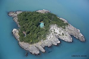
Giresun Island
An island in Turkey
Distance: Approx. 4306 meters
Latitude and longitude: 40.92888889,38.43611111
Giresun Island (Turkish: Giresun Adası) is a small island that has an area of 4 hectares and lies 1.2 km from the Turkish city of Giresun on the southeastern coast of Black Sea. It is the largest island on the Turkish Black Sea coast.
Hamza Stone
Boulder on Giresun Island, Turkey
Distance: Approx. 4381 meters
Latitude and longitude: 40.929,38.437
The Hamza Stone (Turkish: Hamza Taşı) is a large black-colored boulder on the eastern coast of Giresun Island in the Black Sea, located 1.2 km off the coast of the Turkish city of Giresun. The stone, known to locals since around 2000 BCE, symbolizes Cybele, an ancient Anatolian mother goddess. The stone sits on a device, also made of stone, with three legs similar to a very short tripod (saçayak, "saç foot", in Turkish, derived from its use to elevate a saç (pan) above the ground).

Giresun Atatürk Stadium
Football stadium in Giresun, Turkey
Distance: Approx. 1536 meters
Latitude and longitude: 40.9097,38.3719
Giresun Atatürk Stadium is a multi-purpose stadium in Giresun, Turkey. It is currently used mostly for football matches and is the home ground of TFF First League team Giresunspor. The stadium was built in 1941 and currently holds 12191 people.
Giresun Museum
Archaeology museum in Giresun, Turkey
Distance: Approx. 610 meters
Latitude and longitude: 40.91944444,38.39388889
Giresun Museum is a museum in Giresun, Turkey. The museum is in the Zeytinlik neighborhood of Giresun at 40°55′10″N 38°23′38″E. It is a historic basilica named Gogora Church built in the 18th century. It has been constructed with rectangular yellow and brown lime stones adjoined with iron cramps and lead.
Çotanak Sports Complex
Distance: Approx. 5345 meters
Latitude and longitude: 40.88916667,38.43916667
The Çotanak Sports Complex (Turkish: Çotanak Spor Kompleksi) is a stadium in Giresun, Turkey. It has a capacity of approximately 21,500 spectators, after initially being planned for 22,028. It is the new home of Giresunspor, currently playing in the Turkish Süper Lig.

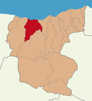
Giresun District
District of Giresun Province, Turkey
Distance: Approx. 1923 meters
Latitude and longitude: 40.9,38.38333333
Giresun District (also: Merkez, meaning "central" in Turkish) is a district of the Giresun Province of Turkey. Its seat is the city of Giresun. Its area is 376 km2, and its population is 145,361 (2022).
Weather in this IP's area
overcast clouds
12 Celsius
11 Celsius
12 Celsius
12 Celsius
1027 hPa
82 %
1027 hPa
998 hPa
10000 meters
1.92 m/s
1.71 m/s
167 degree
99 %