176.216.176.191 - IP Lookup: Free IP Address Lookup, Postal Code Lookup, IP Location Lookup, IP ASN, Public IP
Country:
Region:
City:
Location:
Time Zone:
Postal Code:
IP information under different IP Channel
ip-api
Country
Region
City
ASN
Time Zone
ISP
Blacklist
Proxy
Latitude
Longitude
Postal
Route
Luminati
Country
Region
06
City
cankaya
ASN
Time Zone
Europe/Istanbul
ISP
Vodafone Telekomunikasyon A.S.
Latitude
Longitude
Postal
IPinfo
Country
Region
City
ASN
Time Zone
ISP
Blacklist
Proxy
Latitude
Longitude
Postal
Route
IP2Location
176.216.176.191Country
Region
elazig
City
elazig
Time Zone
Europe/Istanbul
ISP
Language
User-Agent
Latitude
Longitude
Postal
db-ip
Country
Region
City
ASN
Time Zone
ISP
Blacklist
Proxy
Latitude
Longitude
Postal
Route
ipdata
Country
Region
City
ASN
Time Zone
ISP
Blacklist
Proxy
Latitude
Longitude
Postal
Route
Popular places and events near this IP address

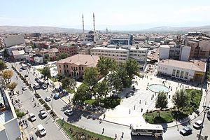
Elazığ
Municipality in Eastern Anatolia, Turkey
Distance: Approx. 34 meters
Latitude and longitude: 38.67444444,39.22277778
Elazığ (Turkish pronunciation: [eˈlazɯː]) is a city in the Eastern Anatolia region of Turkey, and the administrative centre of Elazığ Province and Elazığ District. Founded in and around the former city of Harput, it is located in the uppermost Euphrates valley. The plain on which the city extends has an altitude of 1,067 metres (3,501 ft).
Elazığ Atatürk Stadium
Distance: Approx. 2228 meters
Latitude and longitude: 38.67111111,39.19777778
Elazığ Atatürk Stadium is a stadium in Elazığ, Turkey. It has a capacity of 18,423 spectators. It is the home of Elazığspor.
Elazığ Culture Park
Distance: Approx. 1709 meters
Latitude and longitude: 38.67126667,39.20383333
Elazığ Culture Park (Turkish: Elazığ Kültür Park) is a public park in Elazığ, a city in the Eastern Anatolia region of Turkey. The park is counted as one of the largest parks in the region.
Elazığ Gazi Caddesi
Distance: Approx. 669 meters
Latitude and longitude: 38.67541944,39.21535278
Elazığ Gazi Caddesi (Turkish: Elazığ Gazi Caddesi Kentsel Tasarımı) is the first urban design project in Elazığ, Turkey.
Elazığ Education Campus
Distance: Approx. 2985 meters
Latitude and longitude: 38.64997778,39.20971111

Armenian Evangelical Church, Elâzığ
Distance: Approx. 304 meters
Latitude and longitude: 38.6772,39.2244
The historical Armenian Evangelical Church (Turkish: Ermeni Protestan Kilisesi, Armenian: Հայաստանեայց Աւետարանական Եկեղեցի) is an Armenian Evangelical church located in the centre of the Turkish town of Elazığ (Mamuretül-Aziz), next to Kharpert. After being abandoned due to the Armenian genocide, it has been used as a public toilet. It was built in the 19th century and constituted the headquarters of this church for Elazığ.

Harpoot
Ancient Fortress City in Elazığ, Turkey
Distance: Approx. 4179 meters
Latitude and longitude: 38.705,39.25138889
Harpoot (Turkish: Harput) or Kharberd (Armenian: Խարբերդ, romanized: Kharberd) is an ancient town located in the Elazığ Province of Turkey. It now forms a small district of the city of Elazığ. In the late Ottoman period, it fell under the Mamuret-ul-Aziz Vilayet (also known as the Harput Vilayet).
Elazığ Archaeology and Ethnography Museum
Distance: Approx. 2826 meters
Latitude and longitude: 38.67305556,39.19055556
Elazığ Archaeology and Ethnography Museum is a museum in Elazığ, Turkey The museum is situated in the campus of Fırat University at 38°40′23″N 39°11′26″E. In 1965 a museum was established in a historical building in Harput, a former settlement 5 kilometres (3.1 mi) to the east of Elazığ. During the construction of two hydro electric plants; Keban Dam and Karakaya Dam both of which are on Fırat River (Euphrates of the antiquity) and quite close to Elazığ, many items worthy of museum were found. With these finds a new museum was established in the university campus .

İzzet Pasha Mosque
Mosque in Elâzığ, Turkey
Distance: Approx. 84 meters
Latitude and longitude: 38.67491,39.22393
The İzzet Paşa Mosque (Turkish: İzzet Paşa Camii) is a mosque in Elazığ, Turkey It is on Gazi Paşa boulevard of Elazığ. The commissioner of the mosque was Hacı Ahmet İzzet Pasha, the governor of Elazığ during the Ottoman Empire era. It was completed in 1866.

Elazığ railway station
Railway station in the city of Elazığ, Turkey
Distance: Approx. 1069 meters
Latitude and longitude: 38.6651,39.2227
Elazığ station (Turkish: Elazığ garı) is a railway station in the city of Elazığ, Turkey. TCDD Taşımacılık operates two intercity trains to Ankara or Van, and Adana as well as one regional train to Tatvan. The station was completed, by the Turkish State Railways, on 1 July 1934 and inaugurated on 11 August with a large ceremony.

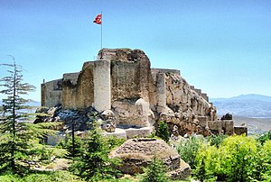
Harput Castle
2800 years old, White Colored Castle in Eastern Anatolia, Turkey
Distance: Approx. 4375 meters
Latitude and longitude: 38.7034,39.2574
Harput Castle, also known as Milk Castle (Turkish: Harput Kalesi, Süt Kalesi), is a castle located in the historical Harput neighborhood within the borders of the current Elazığ Province, Turkey. It was built by the Urartians on a rectangular plan. The castle consists of two parts, internal and external.

Elazığ District
District in Elazığ, Turkey
Distance: Approx. 1050 meters
Latitude and longitude: 38.66666667,39.21666667
Elazığ District (also: Merkez, meaning "central") is a district of Elazığ Province of Turkey. Its seat is the city Elazığ. Its area is 2,243 km2, and its population is 443,363 (2021).
Weather in this IP's area
overcast clouds
2 Celsius
0 Celsius
2 Celsius
2 Celsius
1027 hPa
93 %
1027 hPa
896 hPa
6000 meters
1.54 m/s
230 degree
100 %