176.216.135.84 - IP Lookup: Free IP Address Lookup, Postal Code Lookup, IP Location Lookup, IP ASN, Public IP
Country:
Region:
City:
Location:
Time Zone:
Postal Code:
IP information under different IP Channel
ip-api
Country
Region
City
ASN
Time Zone
ISP
Blacklist
Proxy
Latitude
Longitude
Postal
Route
Luminati
Country
Region
07
City
antalya
ASN
Time Zone
Europe/Istanbul
ISP
Vodafone Telekomunikasyon A.S.
Latitude
Longitude
Postal
IPinfo
Country
Region
City
ASN
Time Zone
ISP
Blacklist
Proxy
Latitude
Longitude
Postal
Route
IP2Location
176.216.135.84Country
Region
isparta
City
isparta
Time Zone
Europe/Istanbul
ISP
Language
User-Agent
Latitude
Longitude
Postal
db-ip
Country
Region
City
ASN
Time Zone
ISP
Blacklist
Proxy
Latitude
Longitude
Postal
Route
ipdata
Country
Region
City
ASN
Time Zone
ISP
Blacklist
Proxy
Latitude
Longitude
Postal
Route
Popular places and events near this IP address

Isparta
Municipality in Turkey
Distance: Approx. 395 meters
Latitude and longitude: 37.76472222,30.55666667
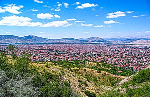
Isparta is a city in western Turkey. It is the seat of Isparta Province and Isparta District. Its population is 247,580 (2022).
Süleyman Demirel University
Public university in Isparta, Turkey
Distance: Approx. 7475 meters
Latitude and longitude: 37.829,30.529
Süleyman Demirel University (SDU) (Turkish: Süleyman Demirel Üniversitesi) is a public university located in Isparta, Turkey. Established in 1992, the university, with around 70.000 students, is the second largest academic institution in Turkey. SDU is known for its programs in agricultural research, medicine, engineering, and business sciences.

Turkish Airlines Flight 452
1976 aviation accident
Distance: Approx. 3760 meters
Latitude and longitude: 37.730666,30.554393
Turkish Airlines Flight 452 was a scheduled domestic passenger flight operated by a Boeing 727-2F2 of Turkish Airlines that crashed near Isparta on 19 September 1976 while en route from Istanbul Atatürk Airport (IST/LTBA) to Antalya Airport (AYT/LTAI), killing all 154 occupants on board. The crash is the deadliest aviation accident in Turkey's history. The aircraft arrived in Istanbul from Italy and took off again at 22:45 local time.
SDU Research Hospital
Hospital in Turkey, Turkey
Distance: Approx. 7110 meters
Latitude and longitude: 37.82756,30.540201
The Süleyman Demirel University Research Hospital (SDU Research Hospital) is a research and teaching hospital located on the Süleyman Demirel University campus. The hospital was founded in 1994 and transferred to its current building in 2000. The new building cost 37148000 USD. The SDU research hospital is a part of the Suleyman Demirel Hospital Network.
Savköy
Municipality in Isparta, Turkey
Distance: Approx. 8610 meters
Latitude and longitude: 37.76666667,30.65
Savköy (also: Sav) is a town (belde) in the Isparta District, Isparta Province, Turkey. Its population is 3,664 (2022).
Isparta Atatürk Stadium
Distance: Approx. 883 meters
Latitude and longitude: 37.76805556,30.56111111
Isparta Atatürk Şehir Stadyumu is a multi-purpose stadium in Isparta, Turkey. It is currently used mostly for football matches and is the home ground of Turkish Regional Amateur League team Ispartaspor. The stadium was built in 1950 and currently holds 4,345 people.
Sanjak of Hamid
Administrative division of the Ottoman Empire
Distance: Approx. 527 meters
Latitude and longitude: 37.76,30.55
The Sanjak of Hamid (also Hamideli) was a second-level province (sanjak) of the Ottoman Empire. The sanjak comprised the region around the town of Isparta, which was ruled by the Hamidids, an autonomous Turkish dynasty that submitted to the Ottomans in 1390 or 1391/92. It became part of the Anatolia Eyalet, but was lost after the Battle of Ankara (1402) and not re-incorporated into the Ottoman state until 1423.
Isparta Museum
Archaeological museum in Turkey
Distance: Approx. 897 meters
Latitude and longitude: 37.77083333,30.55833333
Isparta Museum is a museum in Isparta, Turkey. It is on Millet street in Isparta at 37°46′15″N 30°33′30″E. The museum was opened on 6 March 1985. Following a restoration it was reopened in 2003.

Isparta District
District of Isparta Province, Turkey
Distance: Approx. 318 meters
Latitude and longitude: 37.76666667,30.55
Isparta District (also: Merkez, meaning "central" in Turkish) is a district of the Isparta Province of Turkey. Its seat is the city of Isparta. Its area is 773 km2, and its population is 268,595 (2022).
Weather in this IP's area
broken clouds
7 Celsius
4 Celsius
6 Celsius
7 Celsius
1022 hPa
93 %
1022 hPa
876 hPa
10000 meters
3.09 m/s
40 degree
75 %