176.216.107.227 - IP Lookup: Free IP Address Lookup, Postal Code Lookup, IP Location Lookup, IP ASN, Public IP
Country:
Region:
City:
Location:
Time Zone:
Postal Code:
ISP:
ASN:
language:
User-Agent:
Proxy IP:
Blacklist:
IP information under different IP Channel
ip-api
Country
Region
City
ASN
Time Zone
ISP
Blacklist
Proxy
Latitude
Longitude
Postal
Route
db-ip
Country
Region
City
ASN
Time Zone
ISP
Blacklist
Proxy
Latitude
Longitude
Postal
Route
IPinfo
Country
Region
City
ASN
Time Zone
ISP
Blacklist
Proxy
Latitude
Longitude
Postal
Route
IP2Location
176.216.107.227Country
Region
izmir
City
tan
Time Zone
Europe/Istanbul
ISP
Language
User-Agent
Latitude
Longitude
Postal
ipdata
Country
Region
City
ASN
Time Zone
ISP
Blacklist
Proxy
Latitude
Longitude
Postal
Route
Popular places and events near this IP address
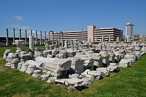
Smyrna
Ancient Greek city, currently İzmir, Turkey
Distance: Approx. 577 meters
Latitude and longitude: 38.41861111,27.13916667
Smyrna ( SMUR-nə; Ancient Greek: Σμύρνη, romanized: Smýrnē, or Σμύρνα, Smýrna) was an Ancient Greek city located at a strategic point on the Aegean coast of Anatolia. Due to its advantageous port conditions, its ease of defence, and its good inland connections, Smyrna rose to prominence. Since about 1930, the city's name has been İzmir.
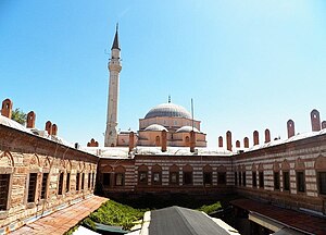
Kemeraltı
Historical market district of İzmir, Turkey
Distance: Approx. 403 meters
Latitude and longitude: 38.41833333,27.13222222
Kemeraltı (more fully, Kemeraltı Çarşısı) is a historical market (bazaar) district of İzmir, Turkey. It remains one of the liveliest districts of İzmir.
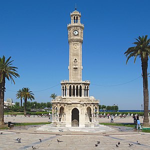
İzmir Clock Tower
Clock tower in İzmir, Turkey
Distance: Approx. 646 meters
Latitude and longitude: 38.41886111,27.12866667
İzmir Clock Tower (Turkish: İzmir Saat Kulesi) is a historic clock tower located at the Konak Square in the Konak district of İzmir, Turkey. It is considered as the main landmark of the city.
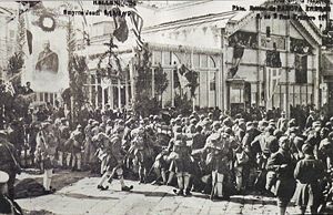
Greek landing at Smyrna
Military engagement
Distance: Approx. 578 meters
Latitude and longitude: 38.4186,27.1392
The Greek landing at Smyrna (Greek: Ελληνική απόβαση στη Σμύρνη; Turkish: İzmir'in İşgali, Occupation of İzmir) was a military operation by Greek forces starting on May 15, 1919 which involved landing troops in the city of Smyrna and surrounding areas. The Allied powers sanctioned and oversaw the planning of the operation and assisted by directing their forces to take over some key locations and moving warships to the Smyrna harbor. During the landing, a shot was fired on the Greek 1/38 Evzone Regiment and significant violence ensued with Greek troops and Greek citizens of Smyrna participating.
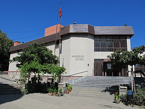
İzmir Archaeological Museum
Archeology museum in İzmir, Turkey
Distance: Approx. 561 meters
Latitude and longitude: 38.41388889,27.12805556
The Izmir Archaeological Museum (Turkish: İzmir Arkeoloji Müzesi) is an archeology museum in İzmir, Turkey, containing a number of artifacts from around the Gulf of İzmir. Most of the artifacts, which include busts, statues, statuettes, tools, and various eating and cooking utensils, come from the Bronze Age, or from the Greek and Roman periods.
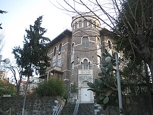
İzmir Ethnography Museum
Ethnographic museum in İzmir, Turkey
Distance: Approx. 529 meters
Latitude and longitude: 38.41372222,27.1285
The İzmir Ethnography Museum (Turkish: İzmir Etnografya Müzesi) is an ethnography museum in İzmir, Turkey. It contains a number of pieces of clothing and pottery from the Seljuk period of Turkish history onwards. Admission to the museum is free.

Salepçioğlu Mosque
Mosque in İzmir, Turkey
Distance: Approx. 258 meters
Latitude and longitude: 38.416944,27.1325
Salepçioğlu Mosque (Turkish: Salepçioğlu Camii) is a mosque in İzmir, Turkey, located in Kemeraltı district in the heart of the city. The mosque which was constructed in the year 1905, is named after its patron Salepçizade Hoca Ahmed Efendi.

Konak Mosque
Mosque in İzmir, Turkey
Distance: Approx. 620 meters
Latitude and longitude: 38.41908333,27.12933333
Konak Mosque (Turkish: Konak Camii), also called Yalı Mosque, is a mosque in İzmir, Turkey. It is located on Konak Square in the heart of the city next to the Governor's Mansion and the İzmir Clock Tower. Despite its relatively small size, it is considered one of the landmarks of the city for its distinctive octagonal shape and elaborate tilework.

Kestanepazarı Mosque
Mosque in İzmir, Turkey
Distance: Approx. 535 meters
Latitude and longitude: 38.4199,27.1347
The Kestanepazarı Mosque (Turkish: Kestanepazarı Camii; meaning "Chestnut Market Mosque") is a historical Mosque in İzmir, Turkey. An inscription on the Mosque recorded by the traveler Evliya Çelebi, stated that it was constructed by Ahmet Ağa in 1078 according to the Islamic calendar (circa 1668 CE). The Mosque was expanded by Eminzade Ahmet Ağa and reached its present-day appearance in the 19th century.
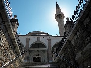
Başdurak Mosque
Mosque in İzmir, Turkey
Distance: Approx. 382 meters
Latitude and longitude: 38.41847222,27.13347222
Başdurak Mosque (Turkish: Başdurak Camii) is a historical Mosque in İzmir, Turkey.

Signora Giveret Synagogue
Orthodox synagogue in İzmir, Turkey
Distance: Approx. 555 meters
Latitude and longitude: 38.42,27.1355
The Signora Giveret Synagogue (Turkish: Sinyora giveret sinagogu), also the La Signora (Geveret) Synagogue, is an Orthodox Jewish congregation and synagogue located at Kemeraltı, 927 Street (known as Havra Sokak (‘Synagogue Street’)), in the city of İzmir, in the İzmir Province of Turkey. The synagogue dates from the 16th century and is in use today.
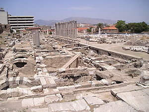
Agora of Smyrna
Square of ancient İzmir
Distance: Approx. 520 meters
Latitude and longitude: 38.41888889,27.13777778
The Agora of Smyrna, alternatively known as the Agora of İzmir (Turkish: İzmir Agorası), is an ancient Roman agora located in Smyrna (present-day İzmir, Turkey). Originally built by the Greeks in the 4th century BC, the agora was ruined by an earthquake in 178 AD. Roman Emperor Marcus Aurelius ordered its reconstruction. Excavations started in 1933.
Weather in this IP's area
clear sky
16 Celsius
15 Celsius
16 Celsius
16 Celsius
1021 hPa
63 %
1021 hPa
991 hPa
10000 meters
3.6 m/s
350 degree
