176.14.118.177 - IP Lookup: Free IP Address Lookup, Postal Code Lookup, IP Location Lookup, IP ASN, Public IP
Country:
Region:
City:
Location:
Time Zone:
Postal Code:
IP information under different IP Channel
ip-api
Country
Region
City
ASN
Time Zone
ISP
Blacklist
Proxy
Latitude
Longitude
Postal
Route
Luminati
Country
ASN
Time Zone
Europe/Moscow
ISP
PVimpelCom
Latitude
Longitude
Postal
IPinfo
Country
Region
City
ASN
Time Zone
ISP
Blacklist
Proxy
Latitude
Longitude
Postal
Route
IP2Location
176.14.118.177Country
Region
stavropol'skiy kray
City
stavropol'
Time Zone
Europe/Moscow
ISP
Language
User-Agent
Latitude
Longitude
Postal
db-ip
Country
Region
City
ASN
Time Zone
ISP
Blacklist
Proxy
Latitude
Longitude
Postal
Route
ipdata
Country
Region
City
ASN
Time Zone
ISP
Blacklist
Proxy
Latitude
Longitude
Postal
Route
Popular places and events near this IP address

Stavropol
City in Stavropol Krai, Russia
Distance: Approx. 1119 meters
Latitude and longitude: 45.05,41.98333333
Stavropol (Russian: Ставрополь, IPA: [ˈstavrəpəlʲ]), known as Voroshilovsk from 1935 until 1943, is a city and the administrative centre of Stavropol Krai, in southern Russia. As of the 2021 Census, its population was 547,820, making it one of Russia's fastest growing cities.

Stavropol Soviet Republic
Distance: Approx. 1119 meters
Latitude and longitude: 45.05,41.98333306
The Stavropol Soviet Republic (Russian: Ставропольская Советская Республика, romanized: Stavropol’skaya Sovetskaya Respublika; 1 January 1918 –7 July 1918) was a short-lived republic on the territory of the former Stavropol Governorate of the Russian Empire. Its capital was Stavropol. It was merged into the North Caucasian Soviet Republic.

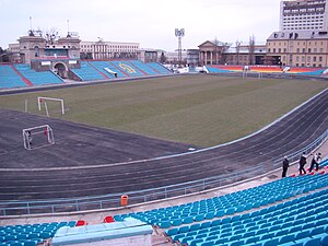
Dynamo Stadium (Stavropol)
Multi-use stadium in Stavropol, Russia
Distance: Approx. 271 meters
Latitude and longitude: 45.0424,41.97
The Dynamo Stadium is a multi-use stadium in Stavropol, Russia. It is used as the stadium of PFC Dynamo Stavropol matches. The capacity of the stadium is 15,589 spectators.

Stavropol Governorate
1847–1924 unit of Russia
Distance: Approx. 1117 meters
Latitude and longitude: 45.05,41.9833
Stavropol Governorate (Russian: Ставропольская губерния, romanized: Stavropol'skaya guberniya) was an administrative-territorial unit (guberniya) of the Russian Empire and the Russian SFSR. It roughly corresponded to most of present-day Stavropol Krai. It was created in 1847 and disbanded in 1924.

North-Caucasus Federal University
University in Russia
Distance: Approx. 4970 meters
Latitude and longitude: 45.04083333,41.91027778
North-Caucasus Federal University (Russian: Северо-Кавказский федеральный университет), abbreviated as NCFU (Russian: СКФУ) is a public university in Stavropol Krai, Russia with campuses in Stavropol, Pyatigorsk and Nevinnomyssk. It was established in 2012 as a flagship university of the newly created North Caucasian Federal District by merging Stavropol State University, North-Caucasus State Technical University, and Pyatigorsk State University of Humanities and Technology.
Stavropol State Agrarian University
Agricultural university in Stavropol, Russia
Distance: Approx. 1134 meters
Latitude and longitude: 45.0376,41.961
Stavropol State Agrarian University is a state institution of higher education in Stavropol, Northern Caucasus. The previous title of the University is Stavropol State Agricultural Academy.
Weather in this IP's area
shower drizzle
-2 Celsius
-8 Celsius
-2 Celsius
-2 Celsius
1023 hPa
100 %
1023 hPa
954 hPa
200 meters
6 m/s
100 degree
100 %