Country:
Region:
City:
Latitude and Longitude:
Time Zone:
Postal Code:
IP information under different IP Channel
ip-api
Country
Region
City
ASN
Time Zone
ISP
Blacklist
Proxy
Latitude
Longitude
Postal
Route
Luminati
Country
Region
tg
City
bischofszell
ASN
Time Zone
Europe/Zurich
ISP
Bluewin
Latitude
Longitude
Postal
IPinfo
Country
Region
City
ASN
Time Zone
ISP
Blacklist
Proxy
Latitude
Longitude
Postal
Route
db-ip
Country
Region
City
ASN
Time Zone
ISP
Blacklist
Proxy
Latitude
Longitude
Postal
Route
ipdata
Country
Region
City
ASN
Time Zone
ISP
Blacklist
Proxy
Latitude
Longitude
Postal
Route
Popular places and events near this IP address

Bischofszell
Municipality in Thurgau, Switzerland
Distance: Approx. 1522 meters
Latitude and longitude: 47.5,9.23333333
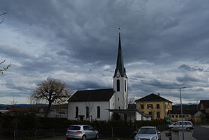
Bischofszell (Alemannic: Bischefzèl) is a village and a municipality in Weinfelden District in the canton of Thurgau in Switzerland. It is the seat of the district. In 1987, the city was awarded the Wakker Prize for the preservation of its architectural heritage.
Hohentannen
Municipality in Thurgau, Switzerland
Distance: Approx. 2763 meters
Latitude and longitude: 47.5,9.21666667
Hohentannen is a municipality in Weinfelden District in the canton of Thurgau in Switzerland.
Zihlschlacht-Sitterdorf
Municipality in Thurgau, Switzerland
Distance: Approx. 1865 meters
Latitude and longitude: 47.51666667,9.26666667
Zihlschlacht-Sitterdorf is a municipality in Weinfelden District in the canton of Thurgau in Switzerland.

Bischofszell District
District in Switzerland
Distance: Approx. 1522 meters
Latitude and longitude: 47.5,9.23333333
Bischofszell District is a former district of the canton of Thurgau in Switzerland. It had a population of 31,773 (as of 2009). Its capital was the town of Bischofszell.
Gottshaus
Village and former municipality in Switzerland
Distance: Approx. 3091 meters
Latitude and longitude: 47.48916667,9.28916667
Gottshaus is a village and former municipality in the canton of Thurgau, Switzerland. It was first recorded somewhere between year 1250 and 1300 as Gottshaus. The municipality also contained the village Sankt Pelagiberg as well as 40 others.

Hauptwil Castle
Castle and Heritage site in Thurgau, Switzerland
Distance: Approx. 2470 meters
Latitude and longitude: 47.48043,9.25176
Hauptwil Castle is a castle in the municipality of Hauptwil-Gottshaus of the Canton of Thurgau in Switzerland. It is a Swiss heritage site of national significance.

Bildegg Castle
Distance: Approx. 3187 meters
Latitude and longitude: 47.503478,9.295562
Bildegg Castle is a castle in the municipality of Zihlschlacht-Sitterdorf of the Canton of Thurgau in Switzerland. It is a Swiss heritage site of national significance.

Bischofszell Nord railway station
Railway station in Switzerland
Distance: Approx. 2013 meters
Latitude and longitude: 47.49638889,9.22805556
Bischofszell Nord railway station (German: Bahnhof Bischofszell Nord) is a railway station in Bischofszell, in the Swiss canton of Thurgau. It is an intermediate stop on the Sulgen–Gossau line.
Sitterdorf railway station
Railway station in Switzerland
Distance: Approx. 243 meters
Latitude and longitude: 47.50111111,9.25555556
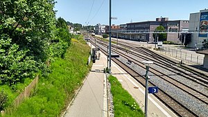
Sitterdorf railway station (German: Bahnhof Sitterdorf) is a railway station in Zihlschlacht-Sitterdorf, in the Swiss canton of Thurgau. It is an intermediate stop on the Sulgen–Gossau line.

Bischofszell Stadt railway station
Railway station in Switzerland
Distance: Approx. 1832 meters
Latitude and longitude: 47.48888889,9.23972222
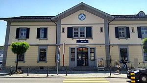
Bischofszell Stadt railway station (German: Bahnhof Bischofszell Stadt) is a railway station in Bischofszell, in the Swiss canton of Thurgau. It is an intermediate stop on the Sulgen–Gossau line.

Hauptwil railway station
Railway station in Switzerland
Distance: Approx. 3079 meters
Latitude and longitude: 47.475,9.25055556
Hauptwil railway station (German: Bahnhof Hauptwil) is a railway station in Hauptwil-Gottshaus, in the Swiss canton of Thurgau. It is an intermediate stop on the Sulgen–Gossau line.
Hudelmoos
Bog in eastern Switzerland
Distance: Approx. 3467 meters
Latitude and longitude: 47.52277778,9.28833333
Hudelmoos is a raised bog and nature reserve in the municipalities of Zihlschlacht-Sitterdorf and Amriswil (Thurgau), and Muolen (St. Gallen), in Switzerland. The bog encompasses 40 hectares (99 acres) and consists mostly of sparse birch forest, with a soft forest floor and multiple streams and ponds.
Weather in this IP's area
broken clouds
11 Celsius
10 Celsius
9 Celsius
15 Celsius
1027 hPa
76 %
1027 hPa
970 hPa
10000 meters
1.63 m/s
0.99 m/s
46 degree
81 %
07:10:07
17:02:54


