Country:
Region:
City:
Latitude and Longitude:
Time Zone:
Postal Code:
IP information under different IP Channel
ip-api
Country
Region
City
ASN
Time Zone
ISP
Blacklist
Proxy
Latitude
Longitude
Postal
Route
Luminati
Country
Region
vd
City
lausanne
ASN
Time Zone
Europe/Zurich
ISP
Bluewin
Latitude
Longitude
Postal
IPinfo
Country
Region
City
ASN
Time Zone
ISP
Blacklist
Proxy
Latitude
Longitude
Postal
Route
db-ip
Country
Region
City
ASN
Time Zone
ISP
Blacklist
Proxy
Latitude
Longitude
Postal
Route
ipdata
Country
Region
City
ASN
Time Zone
ISP
Blacklist
Proxy
Latitude
Longitude
Postal
Route
Popular places and events near this IP address

FC Lausanne-Sport
Sports club in Switzerland
Distance: Approx. 644 meters
Latitude and longitude: 46.54358333,6.62202778
Football Club Lausanne-Sport is a Swiss football club based in Lausanne in the canton of Vaud. Founded in 1896, Lausanne Sport compete in the top-tier Swiss Super League after being promoted in the 2022–23 Swiss Challenge League Season. They play their home games at the 12,544-capacity Stade de la Tuilière.

Lac de Sauvabelin
Artificial lake in Switzerland
Distance: Approx. 1251 meters
Latitude and longitude: 46.5375,6.63833333
Lac de Sauvabelin (literally "Lake of Sauvabelin") is an artificial lake in the Sauvabelin forest, above Lausanne, Switzerland. The city of Lausanne authorized the construction of the lake in 1888. A few years later, Funiculaire Lausanne-Signal was built.

Palais de Beaulieu
Historical building in Lausanne, Switzerland
Distance: Approx. 1041 meters
Latitude and longitude: 46.5286,6.6244
Palais de Beaulieu is the historical and emblematic building of the Lausanne convention and exhibition center, located in Lausanne, in the Vaud Canton, Switzerland. The Palais is a convention centre that welcomes mainly conventions and events. The center includes the Théâtre de Beaulieu concert, dance and theatre hall.

Lausanne Airfield
Airport
Distance: Approx. 927 meters
Latitude and longitude: 46.54527778,6.61666667
Lausanne Airfield, also known as Lausanne-Blécherette Airport, is a small civil aerodrome located in the north of Lausanne, Switzerland. It has no scheduled commercial traffic and is used for general aviation. It also serves as a base for Swiss rescue services.
International School of Lausanne
Private, international school in Switzerland
Distance: Approx. 1427 meters
Latitude and longitude: 46.5447,6.6377
The International School of Lausanne (ISL) is a luxury English-language private school located in the village of Le Mont-sur-Lausanne, just north of Lausanne, Switzerland. ISL was established as the English School of Lausanne in 1962, serving the needs of international and local families for an international primary or secondary education. In 2005 ISL moved from their campuses in Pully into a newly built campus.

Beaulieu Castle
Castle in Lausanne, Switzerland
Distance: Approx. 1203 meters
Latitude and longitude: 46.527183,6.624956
Beaulieu Castle (French: Château de Beaulieu) is a château in the municipality of Lausanne of the Canton of Vaud in Switzerland. It is a Swiss heritage site of national significance.
Tour de Sauvabelin
Tower in Switzerland
Distance: Approx. 1303 meters
Latitude and longitude: 46.53527778,6.63861111
The Tour de Sauvabelin (literally "Tower of Sauvabelin") is a wooden tower located in the Sauvabelin forest in Lausanne, Switzerland. The tower was built in 2003 by Julius Natterer and stands 35 meters high . It offers a panoramic view of the city of Lausanne, Lake Léman, and the surrounding countryside and mountains.

Stade de la Tuilière
Stadium
Distance: Approx. 647 meters
Latitude and longitude: 46.54361111,6.62197222
Stade de la Tuilière is a football stadium in Lausanne, Switzerland. It is the current home of the football club FC Lausanne-Sport. The stadium has a capacity of 12,544.

Montétan railway station
Railway station in Switzerland
Distance: Approx. 1071 meters
Latitude and longitude: 46.53033889,6.61318056
Montétan railway station (French: Gare de Montétan) was a railway station in the municipality of Lausanne, in the Swiss canton of Vaud. It was located on the 1,000 mm (3 ft 3+3⁄8 in) Lausanne–Bercher line of the Chemin de fer Lausanne-Échallens-Bercher (LEB).

Union-Prilly railway station
Railway station in Prilly, Switzerland
Distance: Approx. 992 meters
Latitude and longitude: 46.53471944,6.60985
Union-Prilly railway station (French: Gare d'Union-Prilly) is a railway station in the municipality of Prilly, in the Swiss canton of Vaud. It is located on the 1,000 mm (3 ft 3+3⁄8 in) Lausanne–Bercher line of the Chemin de fer Lausanne-Échallens-Bercher (LEB).

Prilly-Chasseur railway station
Railway station in Prilly, Switzerland
Distance: Approx. 1134 meters
Latitude and longitude: 46.53965,6.60743056
Prilly-Chasseur railway station (French: Halte de Prilly-Chasseur) is a railway station in the municipality of Prilly, in the Swiss canton of Vaud. It is located on the 1,000 mm (3 ft 3+3⁄8 in) Lausanne–Bercher line of the Chemin de fer Lausanne-Échallens-Bercher (LEB).

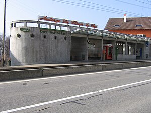
Cery-Fleur-de-Lys railway station
Railway station in Prilly, Switzerland
Distance: Approx. 1504 meters
Latitude and longitude: 46.54458,6.60501
Cery-Fleur-de-Lys railway station (French: Halte de Cery-Fleur-de-Lys) is a railway station in the municipality of Prilly, in the Swiss canton of Vaud. It is located on the 1,000 mm (3 ft 3+3⁄8 in) Lausanne–Bercher line of the Chemin de fer Lausanne-Échallens-Bercher (LEB).
Weather in this IP's area
overcast clouds
15 Celsius
14 Celsius
12 Celsius
15 Celsius
1025 hPa
65 %
1025 hPa
955 hPa
10000 meters
0.32 m/s
0.64 m/s
32 degree
97 %
07:18:25
17:15:40
