Country:
Region:
City:
Latitude and Longitude:
Time Zone:
Postal Code:
IP information under different IP Channel
ip-api
Country
Region
City
ASN
Time Zone
ISP
Blacklist
Proxy
Latitude
Longitude
Postal
Route
Luminati
Country
Region
ag
City
rothrist
ASN
Time Zone
Europe/Zurich
ISP
Bluewin
Latitude
Longitude
Postal
IPinfo
Country
Region
City
ASN
Time Zone
ISP
Blacklist
Proxy
Latitude
Longitude
Postal
Route
db-ip
Country
Region
City
ASN
Time Zone
ISP
Blacklist
Proxy
Latitude
Longitude
Postal
Route
ipdata
Country
Region
City
ASN
Time Zone
ISP
Blacklist
Proxy
Latitude
Longitude
Postal
Route
Popular places and events near this IP address

Aarburg
Municipality in Aargau, Switzerland
Distance: Approx. 1117 meters
Latitude and longitude: 47.31666667,7.9
Aarburg is a historic town and a municipality in the district of Zofingen in the canton of Aargau in Switzerland. The small town lies in the southwest Aargau, in a narrow section of the Aare valley, at the confluence with the Wigger. It lies in the intersection of the most important traffic routes of Switzerland.

Vordemwald
Municipality in Aargau, Switzerland
Distance: Approx. 3189 meters
Latitude and longitude: 47.28333333,7.9
Vordemwald is a municipality in the district of Zofingen in the canton of Aargau in Switzerland.

Oftringen
Municipality in Switzerland
Distance: Approx. 2260 meters
Latitude and longitude: 47.31666667,7.91666667
Oftringen is a municipality in the district of Zofingen in the canton of Aargau in Switzerland.

Rothrist
Municipality in Aargau, Switzerland
Distance: Approx. 1253 meters
Latitude and longitude: 47.3,7.88333333
Rothrist is a municipality in the district of Zofingen in the canton of Aargau in Switzerland.
Boningen
Municipality in Solothurn, Switzerland
Distance: Approx. 1737 meters
Latitude and longitude: 47.31666667,7.86666667
Boningen is a municipality in the district of Olten in the canton of Solothurn in Switzerland.

Wigger (river)
River in Switzerland
Distance: Approx. 625 meters
Latitude and longitude: 47.3156,7.8923
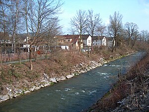
The Wigger (formerly also called Wiggeren) is a river in the Swiss cantons of Lucerne and Aargau. It is an important tributary of the river Aare. The Wigger is around 41 kilometers long and flows from south to north for most of its length.

Aarburg Castle
Castle in Aargau, Switzerland
Distance: Approx. 1552 meters
Latitude and longitude: 47.32164167,7.90093333
Aarburg Castle (German: Festung Aarburg) is a castle in the municipality of Aarburg in the canton of Aargau in Switzerland. It is located high above the town Aarburg on a steep, rocky hillside. The castle was built around a medieval castle, which controlled the narrow point on the Aare river and served as the seat of Aarburg Vogt.

Kleinholz Stadion
Distance: Approx. 3611 meters
Latitude and longitude: 47.3430906,7.8925233
The Kleinholz Stadion is an ice hockey stadium located in Olten, Switzerland. It is mainly used by EHC Olten, an ice hockey club that currently plays in the Swiss National League B. It was built in 1961 and renovated in 2014.

Aarewaage
Distance: Approx. 1295 meters
Latitude and longitude: 47.32,7.8985
The Aarewaage (in local Swiss German dialect: Woog) is a whirlpool phenomenon in the Swiss river Aare at Aarburg, canton of Aargau. In 1996, it was added to the Federal Inventory of Landscapes and Natural Monuments. At the location of the Aarewaage, the river widens into a broader natural basin and at the same time meets a rock on which Aarburg Castle is located.

Aarburg-Oftringen railway station
Railway station in Aargau, Switzerland
Distance: Approx. 1845 meters
Latitude and longitude: 47.32027778,7.90805556
Aarburg-Oftringen railway station (German: Bahnhof Aarburg-Oftringen) is a railway station in the municipality of Aarburg, in the Swiss canton of Aargau. It is located at the junction of the standard gauge Olten–Bern and Olten–Lucerne lines of Swiss Federal Railways.

Rothrist railway station
Railway station in Rothrist, Switzerland
Distance: Approx. 811 meters
Latitude and longitude: 47.30644,7.87938389
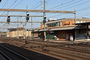
Rothrist railway station (German: Bahnhof Rothrist) is a railway station in the municipality of Rothrist, in the Swiss canton of Aargau. It is an intermediate stop on the standard gauge Olten–Bern line of Swiss Federal Railways. The high-speed Mattstetten–Rothrist new line diverges west of the station but no trains calling at Rothrist use it.

Wangen bei Olten railway station
Railway station in Switzerland
Distance: Approx. 3714 meters
Latitude and longitude: 47.34139,7.86834339
Wangen bei Olten railway station (German: Bahnhof Wangen bei Olten) is a railway station in the municipality of Wangen bei Olten, in the Swiss canton of Solothurn. It is an intermediate stop on the standard gauge Jura Foot line of Swiss Federal Railways.
Weather in this IP's area
scattered clouds
13 Celsius
12 Celsius
10 Celsius
15 Celsius
1026 hPa
62 %
1026 hPa
979 hPa
10000 meters
1.14 m/s
1.08 m/s
78 degree
47 %
07:15:08
17:08:48
