Country:
Region:
City:
Latitude and Longitude:
Time Zone:
Postal Code:
IP information under different IP Channel
ip-api
Country
Region
City
ASN
Time Zone
ISP
Blacklist
Proxy
Latitude
Longitude
Postal
Route
Luminati
Country
ASN
Time Zone
Europe/Bucharest
ISP
Samteco Serv Srl
Latitude
Longitude
Postal
IPinfo
Country
Region
City
ASN
Time Zone
ISP
Blacklist
Proxy
Latitude
Longitude
Postal
Route
db-ip
Country
Region
City
ASN
Time Zone
ISP
Blacklist
Proxy
Latitude
Longitude
Postal
Route
ipdata
Country
Region
City
ASN
Time Zone
ISP
Blacklist
Proxy
Latitude
Longitude
Postal
Route
Popular places and events near this IP address

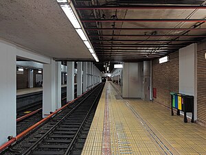
Crângași metro station
Bucharest metro station
Distance: Approx. 1235 meters
Latitude and longitude: 44.45210278,26.04708333
Crângași is a metro station in the Crângași neighborhood, northwestern Bucharest. It was opened to the public on 22 December 1984 as a terminus of the M1 line, one-line extension from Semănătoarea. On 24 December 1987, the line was extended further to Gara de Nord.

Petrache Poenaru metro station
Bucharest metro station
Distance: Approx. 1923 meters
Latitude and longitude: 44.44532,26.0466
Petrache Poenaru, formerly known as Semănătoarea is a metro station in Bucharest, Romania, servicing the Bucharest Metro Line M1. It was named after Semănătoarea, an agricultural machinery factory located in the vicinity, but it is now named after Petrache Poenaru, a Romanian inventor of the Enlightenment era. The metro station services both what is left of the factory (that was severely downsized a number of times), part of the Regie student campus, the Sema Park industrial park, as well as some newly built residential areas.

Grivița metro station
Bucharest metro station
Distance: Approx. 1431 meters
Latitude and longitude: 44.46111111,26.05777778
Grivița is a metro station in northern Bucharest. The station was opened on 1 March 2000 as part of the inaugural section of the line from Gara de Nord to 1 Mai. It is located near the Grivița railroad workshops.

1 Mai metro station
Bucharest metro station
Distance: Approx. 1343 meters
Latitude and longitude: 44.47120833,26.05055556
1 Mai(1st of May in Romanian) is a metro station in northern Bucharest, serving line M4. It is situated in Chibrit or Clăbucet Square, at the intersection of Calea Griviței, Ion Mihalache Boulevard, and Bucureștii Noi Road.It will be serving the M6 line to the airport at Otopeni.
Grivița
District of Bucharest, Romania
Distance: Approx. 1368 meters
Latitude and longitude: 44.462241,26.057017
Grivița ([ˈɡrivitsa]) is a district of Bucharest, Romania, centered on the Grivița Railway Yards (Atelierele CFR Grivița), which were and still are an important landmark within the manufacturing landscape of the city. Located near Gara de Nord, their history dates back to the late decades of the 19th century, when they were developed in order to perform maintenance and overhaul of railway equipment serving Căile Ferate Române. The name reflects the Romanian spelling for Grivitsa, a village near Pleven, where one of the Ottoman redoubts in the Plevna's defenses was stormed and captured with heavy casualties by the Romanian Army during the Romanian War of Independence (see Siege of Plevna).

Giulești
Neighborhood of Bucharest
Distance: Approx. 1419 meters
Latitude and longitude: 44.4539,26.05371111
Giulești (Romanian pronunciation: [dʒjuˈleʃtʲ]) is a neighbourhood in northwestern Bucharest, located in Sector 6. The Giulești Stadium, Giulești Theatre, Podul Grant are located in Giulești. Also, the Grivița Railway Yards and Lacul Morii are located nearby.
Podul Grant
Distance: Approx. 1873 meters
Latitude and longitude: 44.45538611,26.06153889
Podul Grant (Grant Bridge) is a bridge that serves both motorway and lightrail transportation in Bucharest, Romania. It is named after Effingham Grant, the British consul in Bucharest during the mid-19th century. Initially, the bridge was made of steel, and opened in 1910.
Basarab Tower
Distance: Approx. 1966 meters
Latitude and longitude: 44.45208,26.06036
Basarab Tower was an elevator testing building in Bucharest built between 1986 and 1988. It had 23 floors and measured 114 meters. The surface of a level was 400 square meters.
Marin Preda Park
Park in the north-west of Bucharest, Romania
Distance: Approx. 199 meters
Latitude and longitude: 44.4612,26.0421
Marin Preda Park (Romanian: Parcul Marin Preda), formerly known as Giulești Park (Romanian: Parcul Giulești), is a park in the north-west of Bucharest, Romania. It is named for the Romanian novelist, post-war writer and publisher Marin Preda. Opened in 2017, the park is located in Sector 6 of the city and covers an area of 40 hectares (99 acres).

Lacul Morii
Distance: Approx. 1353 meters
Latitude and longitude: 44.45555556,26.02527778
Lacul Morii ("Mill Lake") is the largest lake in Chiajna, with an area of 246 ha (610 acres). The lake is approximately 6 km (3.7 mi) from the center of Bucharest (Piața Unirii) and is located between the Polytechnic University of Bucharest neighborhood to the east, the Crângași and Giulești districts to the north, the Militari district to the south and the village Roșu to the west. The lake is a reservoir, made in 1986 mainly to protect the city against floods.
Bright Light (CIA)
CIA black site in Bucharest
Distance: Approx. 836 meters
Latitude and longitude: 44.467955,26.046033
Bright Light is the codename of one of the Central Intelligence Agency's network of black sites—clandestine interrogation centers. The location of the site, in Bucharest, Romania, was confirmed in an exclusive report from the Associated Press on December 8, 2011. Some of the most important captives in the high value detainee program, including Khalid Sheikh Mohammed, the mastermind of the September 11 attacks, were held there.

Rapid-Giulești Stadium
Football stadium in Romania
Distance: Approx. 1506 meters
Latitude and longitude: 44.45605556,26.05688889
The Rapid-Giulești Stadium, known as Superbet Arena-Giulești for sponsorship reasons, is a football-specific stadium located in the Giulești neighbourhood of Bucharest, Romania. It has been home to Liga I club Rapid București since its opening in March 2022, and has a capacity of 14,047 people. Rapid-Giulești cost €67 million and replaced the original Giulești-Valentin Stănescu Stadium.
Weather in this IP's area
clear sky
8 Celsius
7 Celsius
8 Celsius
8 Celsius
1031 hPa
47 %
1031 hPa
1020 hPa
10000 meters
2.68 m/s
230 degree
06:56:07
17:02:37
